Back to "green paradise"
(Baonghean) - Following the call of the roads and the deep green forests of the Western region of Nghe An, we had an interesting journey... Now, the Western region is in the middle of the dry season, gradually becoming dreamy with the gentle sunlight, making the cheeks of the Thai girls happily going to the festival more rosy...
The leader of our “backpacking” group this time is Nguyen Cuong, an officer of the Department of Agriculture and Rural Development, specializing in the seafood sector. Working all year round in the coastal region, so whenever he has free days off, Cuong goes to the mountainous areas. Pu Mat National Park – this destination, Cuong has been to a couple of times, now he is playing the role of “scout”. Cuong also clearly knows that Pu Mat in Thai means “high mountain”; the park is named after the highest peak in the region (1,841m). Pu Mat National Park is famous at home and abroad for the discovery of the endemic saola and many rare species of animals and plants listed in the World Red Book… Without the ambition to see some of the park’s endemic species of animals and plants, or to conquer Pu Mat peak, we only hope to enjoy the beautiful scenery, learn about human life in this world biosphere reserve.
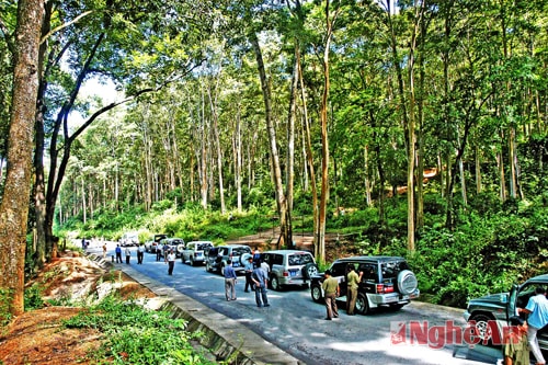 |
| Tourists visit Pu Mat National Park. Photo: Sy Minh |
And this is Cao Veu area - Anh Son district, in the buffer zone of Pu Mat National Park. Cao Veu land has only been exploited in the last 20 years or so. Thai people who migrated from other places to Cao Veu said: When the forest is stormy, elephants often come here, on rainy nights from the distant mountains, the sound of tigers roaring still echoes... Pu Mat is the long-standing habitat of the Thai people. On the hillsides, riverbanks, and streams, they build stilt houses, grow rice, grow crops, cultivate fields, raise livestock and poultry, and live together in villages. Pu Mat forest is very dark and wild, in many places there have never been any human footprints. Unable to go through the forest, Cuong led us along Highway 7 to Con Cuong district, from Khe Diem intersection, turning into Luc Da, Mon Son (names that seem to evoke legends).
The first scenic spot we encountered was Moc stream in Nua village - an underground stream that flows through limestone mountains - and then suddenly appears on the ground. Moc stream's water is crystal clear and cool in the middle of the scorching summer. In the Thai villages of Mon Son and Luc Da communes, they have long cooperated with companies to open community tours. Visitors can come here to learn about the lives of local residents by eating and sleeping at home, watching how to prepare traditional dishes or the traditional brocade weaving craft. "Brocade in Mon Son is beautiful in its materials, colorful colors and unique patterns. Because it is made entirely by hand, it takes at least 1 day to weave a brocade scarf, 2 days to make a handbag, and 10 days to weave a dress" - Ha Thi Hong, a girl in Xieng village introduced.
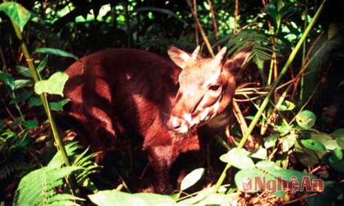 |
| Saola in Pu Mat National Park |
The Thai people in Mon Son - Luc Da land live together in clans, with some unique beliefs and customs, and bamboo pole dancing and drinking rice wine are unmistakable characteristics in daily life. Every year, on April 14 and 15, the Mon Son Luc Da Festival is held here. The festival is associated with the wish for a bountiful harvest and prosperity, and is also an occasion for the people and ethnic groups in the West to remember their predecessors, the excellent children of their homeland who wholeheartedly followed the Party to make revolution; contributing to promoting the cultural identity that the people here have built and preserved for thousands of years. The festival takes place with many cultural, artistic and sports activities, traditional folk games imbued with national identity such as bamboo pole dancing, throwing con, playing volleyball, tug of war, shooting crossbows, pushing sticks, walking on stilts, culinary competitions, and brocade weaving competitions.
In particular, the "Beauty of Mon Son" contest is highly anticipated by many people. In Mon Son commune, in addition to the Thai people, there are also a group of Kinh and Dan Lai people. Ms. Ngan Thi Ha, Chairman of the People's Committee of Mon Son commune, said: In order to preserve and sustainably develop the Dan Lai ethnic minority, in 2006, the Prime Minister approved the project, and all levels and sectors have made many investments to raise awareness and living standards for the Dan Lai people. In Mon Son, the Dan Lai people live in 3 villages: Co Phat, Con and Bung. To get to these 3 villages, you have to row a boat upstream to the upper reaches of the Giang River...
Next to the Pha Lai irrigation dam (Thai means flower of heaven), stretching out as far as the eye can see, a majestic and poetic scene of mountains, forests and rivers appeared. We boarded a dugout canoe with a motor to begin our "adventure" journey into the Dan Lai village. The scenery of the Giang River and the Pu Mat forest canopy appeared from many different angles: steep, majestic limestone mountains, dense trees, and hanging clusters of orchids. The sounds of birds, cicadas and animals, along with the sound of the river water created a typical symphony of the deep Western wilderness. Mr. Nguyen Van Hung, the boatman, told us about the Giang River: the Giang River itself, stretching over 100 km, is a wonder that nature has bestowed upon the Western region of Nghe An.
The gentle river originating from the Vietnam - Laos border is not only the "unique" traffic route to the core area of Pu Mat, but also the livelihood of the indigenous people. Giang River is sometimes fierce, but also very gentle, the river carries alluvium for the corn and potato fields downstream to always be green, and the river is also the habitat of cool fish - a species of fish that lives in schools in the crevices of rocks, cool fish is both healthy and nutritious as its name, delicious meat, few bones, especially eating cool fish has the effect of increasing milk production, limiting cardiovascular diseases, very suitable for the elderly. Cool fish of Giang River is now considered by Nghe people as a rustic specialty, delicious in any way of preparation...
Co Phat village, home to 97 Dan Lai households, now has electricity, roads, schools, and stations. Life is improving. Village roads and alleys are clean, bamboo fences surround sturdy stilt houses nestled on the hillside, covered by the green of corn and cassava fields. Not only our group visited the Dan Lai ethnic group, but also many other groups. Here, we met domestic and foreign scientists who research biodiversity; representatives of tourism companies surveying and opening tours, border guards and officers of Pu Mat National Park; the district and commune regularly visit, care for, and guide the people on how to make a living. On the Giang river wharf in Co Phat village, watching the river flow under the midday sun, children herding buffaloes down to bathe is a poetic feeling that brings us back to our childhood, blending into the arms of Mother Nature. Getting on the boat of the village chief of Co Phat La Van Linh to Pha Lai wharf, we left Mon Son to go to Kem waterfall, in Yen Khe commune, a wonderful landscape. The majestic Kem waterfall is 500m high. It is said that many scientists, when researching here, have confirmed that Kem waterfall is the most pristine waterfall in Vietnam. The Thai people here still call Kem waterfall Bo Bo, meaning white silk strip. Indeed, looking up from the foot of the waterfall, the water from above pours down strongly through 3 steps with white foam like cotton. Above and on both sides of the waterfall is a carpet of vegetation with hundreds of species of flowers blooming all year round. At the foot of the waterfall is a long stream with flat rocks like large tables as a resting place for tourists. Also at the foot of the waterfall, there are small lakes of different depths. In the dry and sunny weather of the Lao wind season, the area around the waterfall is always cool at about 20 degrees Celsius - "scout" Nguyen Cuong said. There are accommodation facilities and services for tourists here.
Continuing on the roads, we visited Tra Lan citadel, Ma Nhai stele, Ong Trang cave (Con Cuong town); admired the ancient Sang Le forest, about 50m high and providing shade all year round in Tam Dinh commune, Tuong Duong district. The air here is fresh and the scenery is incredibly peaceful, as if lulling people into an afternoon nap, dispelling fatigue. Through sparse forests, dense forests, shrubs and herbs, we came to the vast primeval forests, pure po mu and sa mu, with trees up to nearly 5m in diameter in the upper reaches of Thoi stream, Bu stream, Choang stream; visited the rare Vietnamese heritage tree, Sa mu dau, identified as an endangered species, about 70m high (rated by the Vietnam Association for Conservation of Nature and Environment as the tallest tree in Vietnam today)...
Visit the Center for Ecotourism and Environmental Education, the Wildlife Rescue Center, the Botanical Garden, the Nursery, and the Lang Au Communal House in the administrative office area of the Park. We were informed by Mr. Nguyen Thanh Nhan, Director of Pu Mat National Park: Pu Mat National Park is currently identified as the core zone of the Western Nghe An Biosphere Reserve recognized by UNESCO in 2007. Pu Mat National Park has many advantages in developing tourism. Currently, the Park staff in particular and the people of Nghe An in general are making efforts to protect biodiversity, protect natural resources, manage and protect forests, maintain diversity which is a tourism resource... Currently, Nghe An province is calling for investment focusing on key ecotourism projects, including the Pu Mat National Park Ecotourism Area. It is known that in February, the province had a working session with Vietravel Tourism Company to consider building tourism products. Certainly, in the product "Journey to the homeland of the great man", Pu Mat is a popular destination.
I still like to call Pu Mat “green paradise”, not only does this place have the most biodiversity in Vietnam, but it also always carries the promise of many tourists that “the peak of Fansipan, the roof of Indochina, has been conquered by many people; the pristine peak of Pu Mat in Nghe An, although lower, has not been climbed by anyone yet”. I also told myself that this trip could not conquer the high mountains of the “green paradise” of the West of the country, but I will come back!
Thanh Son