Hoang Sa and Truong Sa of Vietnam - Historical evidence
(Baonghean.vn) - Right in the middle of Truong Sa, on April 24, 2014, for the first time, islanders witnessed an exhibition displaying historical evidence, organized by the Department of Foreign Information - Ministry of Information and Communications, proving sovereignty over the land where they live and work.
Nearly 120 documents, maps, and photos of islands and island points in the archipelago are displayed at the Exhibition. In particular, the Exhibition also uses documents from foreign countries and some published by China itself to prove that the Hoang Sa and Truong Sa archipelagos belong to Vietnam's sovereignty in the East Sea.
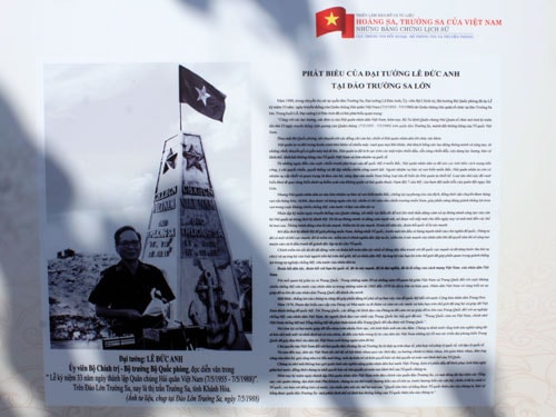
The exhibition of maps and documents “Hoang Sa - Truong Sa, historical evidence” was solemnly held right under the sovereignty marker of Truong Sa Lon island. Ancient maps of Vietnam, China and the West show Vietnam’s sovereignty over the two archipelagos of Hoang Sa and Truong Sa.
 |
 |
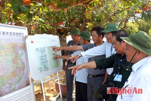 |
Delegates viewed valuable documents about Truong Sa and Hoang Sa on Truong Sa island.
The documents and maps displayed in the exhibition were collected from Vietnam and other countries around the world, including China. The content of the documents and maps shows that the ancestors of the Vietnamese people and the Vietnamese states through the periods have explored, established, enforced and protected national sovereignty since before the 17th century.
With nearly 120 maps, documents, texts and publications displayed at the exhibition is a collection of previously published sources of documents by domestic and international researchers and scholars. The exhibition is divided into groups of documents: Vietnamese feudal court documents from the 17th century to the early 20th century, affirming that Vietnam established and continuously exercised sovereignty over the two archipelagos of Hoang Sa and Truong Sa. 19 royal documents of the Nguyen Dynasty, dating from the Minh Mang Dynasty (1820-1841) to the Bao Dai Dynasty (1925-1945) showing the process of establishing and protecting sovereignty. Version 05 from the 2nd year of Gia Long (1803) to the 17th year of Minh Mang (1836) records the establishment of an army to survey the lands of Hoang Sa. Version 15 of administrative documents of France and the Republic of Vietnam on the exercise of sovereignty over the Hoang Sa archipelago. The map collection includes 60 plates proving Vietnam's sovereignty over the Hoang Sa and Truong Sa archipelagos published by Vietnam, Western countries and China from the 16th century to the present.
19 Chau Ban are state-level administrative documents showing the process of exercising sovereignty of the Nguyen Dynasty over the two archipelagos of Hoang Sa and Truong Sa. This is evidence that the Nguyen Dynasty kings were very interested in the issue of exercising sovereignty over Hoang Sa and Truong Sa by continuously sending people to the two archipelagos to: Survey, plant markers, draw maps, rescue ships of Vietnam and other countries in the region. The book Quoc Trieu Chinh Bien Toat Yeu, compiled by the National History Institute of the Nguyen Dynasty under the Duy Tan Dynasty (1907 - 1916), describes the terrain and history of the two archipelagos of Hoang Sa and Truong Sa. The documents about Quang Ngai prefecture in the book Dai Nam Nhat Thong Chi, compiled by the National History Institute of the Nguyen Dynasty, reflect the Nguyen Dynasty's recruitment of Ly Son islanders to join the Hoang Sa Team and send them to the Hoang Sa and Bac Hai (Truong Sa) archipelagos to exploit seafood, establishing sovereignty over these two archipelagos.
The map of Dai Nam Nhat Thong, drawn by King Minh Mang in 1838, shows the two places Hoang Sa and Van Ly Truong Sa in Chinese characters. The Commander of the Saigon Navy and Army mobilized soldiers to replace the troops guarding the Hoang Sa archipelago in 1969. Besides Vietnamese publications, there are also research works by international experts, denying the absurdity of China's sovereignty claim. The exhibition also uses documents from foreign countries and, in particular, published by China itself, proving that the Hoang Sa and Truong Sa archipelagos belong to Vietnam's sovereignty in the East Sea.
With important evidence, affirming Vietnam's sovereignty over the sea and islands, it has been introduced in the exhibition "Hoang Sa, Truong Sa of Vietnam - Historical evidence". This historical evidence will remind every Vietnamese citizen at home, overseas Vietnamese, especially the young generation about Vietnam's sovereignty over the Hoang Sa and Truong Sa archipelagos.
To have the vibrant island of Truong Sa today, generations of fathers and grandfathers have endured hardships and sacrificed to protect the sacred sovereignty of the Fatherland. These documents will help cadres, people from the mainland, and overseas Vietnamese when visiting the island to better understand the historical and legal evidence affirming Vietnam's sovereignty over the Hoang Sa and Truong Sa archipelagos. Seeing with their own eyes historical documents right where they live and work will be a motivation to encourage the soldiers and people on the island to make efforts to build, maintain their guns, and firmly protect the sacred sovereignty of the sea and islands of the Fatherland Vietnam. Through the exhibition, it also contributes to refuting China's unreasonable claims over the Hoang Sa and Truong Sa archipelagos.
Truong Sa, April 2014
Phan Nguyen Hao
Nghe An Department of Information and Communications