

Lam River, the river of glorious victories
I've been fortunate enough to visit the border region, where the Nam Non and Nam Mo rivers flow into Vietnam. I've also been to Cua Rao, the confluence of these two rivers that gives birth to the Lam River, a symbol of Nghe An's culture. And I've strolled through Cua Hoi, where the river merges with the vast ocean. Anyone who has the chance to travel up and down the Lam River will surely feel immense pride in their homeland's waterways, a flow of time containing countless historical and cultural layers…
(Baonghean)I've been fortunate enough to visit the border region, where the Nam Non and Nam Mo rivers flow into Vietnam. I've also been to Cua Rao, the confluence of these two rivers that gives birth to the Lam River, a symbol of Nghe An's culture. And I've strolled through Cua Hoi, where the river merges with the vast ocean. Anyone who has the chance to travel up and down the Lam River will surely feel immense pride in their homeland's waterways, a flow of time containing countless historical and cultural layers…
According to geographical data, the Lam River originates in Laos and flows through Vietnam for over 360 km. After entering Vietnam, it passes through numerous treacherous rapids in Ky Son and Tuong Duong districts, where the Nam Non and Nam Mo rivers meet at the Cua Rao junction in Xa Luong commune (Tuong Duong). From there, the river takes the name Ca River (large river), also known as the Lam River. The Lam River is the lifeblood of Nghe An province, contributing to the formation and nurturing of the region's rich historical and cultural traditions. In other words, this river is intertwined with the fate and ups and downs of Nghe An province throughout its history of nation-building and defense. It is truly not an exaggeration to say that every stretch of the river and every riverbank contains a historical story. The river continues its relentless flow into the vast ocean, time continues its endless course, and historical landmarks still stand tall along the banks and in the hearts of the people of Nghe An.
Let's begin at the Cua Rao junction, the source of the poetic Lam River. Every time I set foot here, I'm reminded of journalist Do Doan Hoang's words: "Then I realize that in our country there's something almost religious about river junctions. Every river junction has its own legends and myths, its own sacredness, its own region of forest, land, water, and sky that locals and travelers alike are captivated by and seek out..." Indeed, for generations, in the hearts of the local people, the Cua Rao junction has been a very sacred place. Sacred because on the sandbar located in the middle of the river junction stands an ancient temple, a place where the spiritual lives of the upstream inhabitants are entrusted. Sacred because here stand ancient trees, thousands of years old, casting their shadows onto the clear blue water, like witnesses throughout the course of history. It was also here that archaeologists discovered many valuable artifacts such as stone tools, bronze drums, and some weapons made of bronze, and named this site Temple Hill. The artifacts discovered at the Temple Hill archaeological site have been identified as belonging to the Phung Nguyen culture, dating back approximately 4,000 years. Thus, more than four millennia ago, the banks of the Lam River became a place of residence and production for the ancient Vietnamese people.
Nghe An province was once the "frontier" of the Dai Viet nation. It served as a strategic outpost, with successive dynasties defending every inch of the border against invasions from Champa, Laos, and Bon Man. The banks of the Lam River still bear the indelible marks of a time of war, and stories of that era of conflict remain. And when speaking of Nghe An, we cannot fail to mention the contributions of Uy Minh Vuong Ly Nhat Quang (988-1057), who was instrumental in attracting settlers, developing the land, and securing the borders. After moving the capital from Hoa Lu to Thang Long, the Ly dynasty sent him here to establish order and maintain stability. Following the court's orders, Ly Nhat Quang implemented many strategies to develop the economy and maintain the border, such as directing the militia to expand production and dig irrigation canals.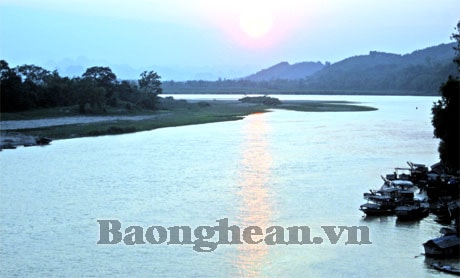
The Lam River section flowing through Anh Son district.
In particular, with the strategic vision of a general well-versed in military strategy, he was the one who opened the main road from the Bạch Đường administrative center (Bồi Sơn commune, Đô Lương district today) along the Lam River, all the way to the Ai Lao border region (Kỳ Sơn district). National Highway 7A, running along the Lam River today, is a remnant of that ancient main road, closely associated with the name and pioneering contributions of Uy Minh Vương Lý Nhật Quang. According to historical records, he was wounded in a battle with the Ai Lao invaders in western Nghệ An and died while retreating to the Bạch Đường administrative center. Along the way, wherever his blood spilled on the ground, the local people erected temples to worship him. Therefore, today, along the Lam River, we often encounter temples dedicated to Lý Nhật Quang. One such temple is Quả Sơn, majestically situated in the former Bạch Đường area – one of the four "sacred places" according to the beliefs of the people of Nghệ An. Further north, in the districts of Anh Son, Con Cuong, and Tuong Duong, there are temples dedicated to Uy Minh Vuong. It is known that in the Thanh-Nghe-Tinh region, there are more than 50 temples dedicated to Ly Nhat Quang. Thus, nearly 1,000 years have passed, through countless changes and vicissitudes, yet the Lam River still bears witness to and illuminates the merits of Uy Minh Vuong Ly Nhat Quang, allowing the people of Nghe An today to be even more proud of their tradition of nation-building and national defense.
Let's return to the upper reaches of the Lam River, where a sacred temple stands at the legendary confluence of the rivers. This temple has a history of nearly 700 years and has two names: Cửa Rào Temple and Vạn Temple. The confluence of the rivers marks the sacrifice of Trần Dynasty generals and soldiers in the war against the Lao invaders to defend the borders. Legend says that around 1335, the Lao invaders invaded and harassed the Nam Nhung region (comprising the present-day Kỳ Sơn, Tương Dương, and Con Cuông districts). Faced with this foreign invasion, despite his advanced age, Emperor Trần Minh Tông decided to personally lead the army into the western border region of Nghệ An to suppress the invaders and secure the borders. The Emperor appointed Đoàn Nhữ Hài, then commander of the Thần Vũ and Thần Sách armies and concurrently serving as the Governor of Nghệ An, as the commander. In a battle at the confluence of the rivers, due to dense fog and a surprise ambush, the Trần Dynasty commander and many of his soldiers perished. After the war ended, life returned to peace. The people of Nam Nhung hamlet erected a temple on the strip of land at the confluence of three rivers to commemorate the contributions of the Trần Dynasty's military commander who sacrificed himself for the peace of the border region. Further south, in Con Cuông, on the cliff of Thành Nam mountain in Chi Khê commune, there still stands a stele inscribed by Nguyễn Trung Ngạn in 1335, commonly known as the Ma Nhai Stele (Ma Nhai Kỷ Công Bi Văn). The content of the Ma Nhai Stele praises the prestige of the Trần Dynasty and the merits of Emperor Emeritus Trần Minh Tông and the Trần Dynasty's soldiers in repelling the Lao invaders.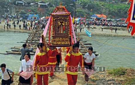
Festival at the headwaters of the Lam River.
Looking across the river from Thanh Nam mountain lies Bong Khe, where remnants of Tra Lan fortress still remain. Nearly 600 years ago, King Le Loi of Binh Dinh led the Lam Son army in a decisive battle, marking a crucial turning point in the great campaign against the Ming invaders. After capturing Tra Lan fortress, the Lam Son army continued down the Lam River to conquer Nghe An, expanding their base and creating opportunities to advance northward. Today, many mountain, land, and village names along the Lam River still bear the strong imprint of Le Loi's army's campaign to repel the Ming invaders. These include Bai Xa, Bai So (Tuong Duong), Do Rong, Bo Ai, Kha Luu (Anh Son), and Lam Thanh (Hung Nguyen) – places where the Ming general Thai Phuc had to "open the gates and surrender"... To elaborate on the legend of Do Rong ferry landing (now in Tuong Son commune, Anh Son district), the section of the river flowing through here has a protruding mountain that abruptly blocks the water flow and changes direction, creating a deep gorge with many dangerous whirlpools. Legend says that to guard against the enemy, Le Loi and his generals chose this area to cross the river to the right bank to observe their positions at Bo Ai and Kha Luu. Therefore, the ferry carrying Le Loi across the river was called Do Rong (Dragon Ferry), and the place where Le Loi sat observing the enemy was called Ben Ngu (Royal Ferry).
Speaking of the Lam River, one cannot fail to mention Cua Hoi, where the river merges with the vast sea. After a journey of hundreds of kilometers, navigating countless treacherous rapids and waterfalls, passing through numerous villages, and tirelessly depositing alluvial soil on fields and plains, the river concludes its mission here. Like Cua Rao – its source, Cua Hoi – its end point – is also a sacred land holding a crucial position in the nation-building and defense efforts. Cua Hoi, formerly part of Vinh Doanh Prefecture, was the southeastern outpost of Dai Viet. During the Later Le Dynasty, Grand Marshal and Duke Nguyen Su Hoi (eldest son of Grand Tutor and Duke Nguyen Xi), appointed as the commander of the twelve sea gates (managing the twelve sea gates from Sam Son to Cua Tung), chose this area to establish his naval headquarters. From then on, successive feudal dynasties of Dai Viet chose this place as a naval base to protect sovereignty and territorial waters. Therefore, it can be said that Cua Hoi is a forward outpost, a strategic location for dealing with threats from the sea.
During the two wars of resistance against France and the United States, the Lam River also bore the weight of heroic deeds, with once-famous landmarks such as Ben Thuy (Vinh town), Van Ru (Nam Dan), and the Do Luong ferry crossing... Under the rain of bombs and bullets from the enemy, countless troops crossed the river to reach the front lines, and the ferries remained steadfast and patient as the battlefield in the South beckoned.
Throughout the course of history and across vast space, the Lam River has carried the weight of glorious victories and, on numerous occasions, the blood of our ancestors shed to secure a peaceful life. We must never forget this, and no one is allowed to harm our homeland river...
Cong Kien