

A new tropical depression has formed over the South China Sea.
The tropical depression is located approximately 350 km east of Song Tu Tay Island.
According to the National Center for Hydro-Meteorological Forecasting: At 13:00 on August 5th, the center of the tropical depression was located at approximately 11.2 degrees North latitude; 117.5 degrees East longitude, about 350 km east of Song Tu Tay Island (part of the Truong Sa archipelago).
The strongest winds in the area near the center of the tropical depression are at level 6 (i.e., from 39 to 49 km/h), with gusts at level 7 and 8.
The forecast for the next 24 hours indicates that the tropical depression will move in a direction between west-northwest and northwest, traveling at approximately 15-20 km per hour, and has the potential to intensify further.
;)
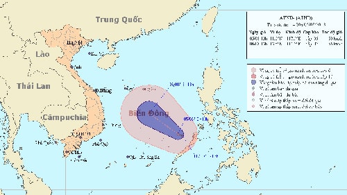
Path of the tropical depression
As of 13:00 on August 6th, the center of the tropical depression was located at approximately 13.5 degrees North latitude and 114.3 degrees East longitude, about 460km south-southeast of the Hoang Sa archipelago.
The strongest winds in the area near the center of the tropical depression are at level 7 (i.e., from 50 to 61 km/h), with gusts at levels 8 and 9.
Due to the influence of the tropical depression, the eastern sea area of the Central and Southern South China Sea (including the sea area northeast of the Spratly Islands) will experience strong winds of force 6, 7, gusting to force 8, 9. The sea will be rough.
Furthermore, due to the strong southwest monsoon, the sea area from Binh Thuan to Ca Mau and the southern South China Sea (including the sea area around the Spratly Islands) will experience strong winds of level 5, sometimes level 6, gusting to level 7, along with heavy rain and thunderstorms. The sea will be rough. Tornadoes should be anticipated during thunderstorms.
According to vov.vn - LT