The strongest wind near the storm center is level 14, gusting to level 17.
The center of the storm is located at about 21.6 degrees North latitude; 118.4 degrees East longitude, about 450km from Hong Kong (China)...
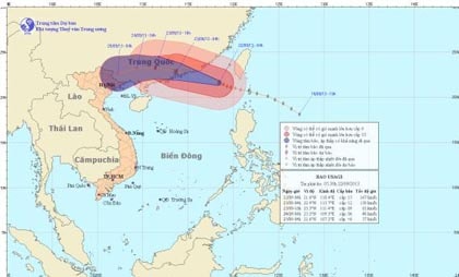
At 4:00 a.m. on September 22, the center of the storm was at about 21.6 degrees North latitude; 118.4 degrees East longitude, about 450 km East Southeast of Hong Kong (China). The strongest wind near the center of the storm was at level 14, level 15 (ie from 150 to 183 km per hour), gusting above level 17.
Storm path and location
Forecast in the next 24 hours, the storm will move in the direction between West and West Northwest, traveling about 20km per hour. At 4:00 on September 23, the center of the storm was at about 22.9 degrees North latitude; 113.7 degrees East longitude, on the coastal area between Hong Kong and Macau (China). The strongest wind near the center of the storm is level 12 (ie from 118 to 133 km per hour), gusting to level 13, level 14.
In the next 24 to 48 hours, the storm will continue to move in the West and West Northwest direction, traveling about 20km per hour, moving deep into the mainland and gradually weakening into a tropical depression. At 04:00 on September 24, the center of the tropical depression was at about 23.2 degrees North latitude; 109.3 degrees East longitude, on the mainland of the Southeast of Guangxi province (China). The strongest wind near the center of the tropical depression is level 6 (ie from 39 to 49 km per hour), gusting to level 7.
During the next 48 to 72 hours, the tropical depression is likely to change direction and move towards the West and West Southwest, moving about 10km per hour and gradually weakening into a low pressure area.
Due to the influence of the storm circulation, the northeastern sea area of the East Sea has strong winds of level 12, level 13, the area near the storm center has winds of level 14, level 15, gusting above level 17. The sea is very rough.
In addition, due to the influence of southwest winds, the sea area from Binh Thuan to Ca Mau and the South East Sea area (including the sea area of Truong Sa archipelago) has strong southwest winds of level 5, sometimes level 6, gusting to level 7. Rough seas./.
According to vov.vn - LT