Floods in Central Vietnam remain complicated
The historic flood has killed dozens of people, flooded over 100,000 houses... and is assessed to be evolving complicatedly, with many areas still isolated.
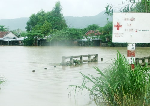
 |
| The sudden floods isolated many places in the Central region, forcing people to use boats to travel. Photo: Nguyen Dong |
The Flood and Storm Prevention Center of the Central and Central Highlands regions said that as of 10 p.m. on November 16, 24 people had died due to floods. Of these, 12 people were killed in Binh Dinh province alone; 8 people were in Quang Ngai, 2 people were in Quang Nam, 1 person was in Kon Tum and 1 person was in Gia Lai. This number is different from the record of VnExpress inThe localities are 29 people..
In addition, the historic flood in 1999 collapsed and swept away 53 houses in Quang Ngai, Phu Yen, Binh Dinh and Khanh Hoa; 166 houses had their roofs blown off, about 110,000 houses from Thua Thien - Hue to Ninh Thuan were flooded; more than 1,000 hectares of rice and 691 hectares of crops were flooded and damaged.
Provinces from Quang Nam to Phu Yen have evacuated more than 19,000 households with nearly 79,000 people from coastal areas, areas at risk of flash floods, landslides, low-lying areas... to safe places. Quang Ngai alone evacuated more than 16,000 households with nearly 67,000 people.
The Flood and Storm Prevention Center of the Central and Central Highlands regions assessed that the current flood situation is still complicated. Binh Dinh is the province that is most severely affected with more than 98,000 houses flooded. Of which, Tuy Phuoc district is 80% flooded, many communes are cut off and isolated by floodwaters. Heavy rain also caused flash floods in An Dung, An Vinh, An Nghia, An Toan, An Quang communes (An Lao district). The entire Eastern dike system is flooded (42/47km), the average flood depth is 0.5 m, the deepest point is 1 m.
In Quang Nam, Dien Ban, Dai Loc, Duy Xuyen districts and Hoi An city were flooded on a large scale. In Quang Ngai, 40 communes in the basins of Ve, Tra Khuc, Tra Cau, Tra Bong rivers in Nghia Hanh, Mo Duc, Tu Nghia, Son Tinh districts, Quang Ngai city, Duc Pho, Binh Son were submerged in water, many places were isolated.
 |
| La Hai road bridge was submerged in flood water, traffic was completely stopped. Photo: Chi Phan |
In Phu Yen, by the afternoon of November 16, the rainfall had decreased but floods were still threatening the downstream area of the Ba River. The Song Ba Ha Hydropower Plant was discharging floodwaters at a rate of more than 3,700 m3/second. Mr. Pham Dinh Phung, Vice Chairman of the People's Committee of Son Hoa district, said that he was ready to arrange people and vehicles to proactively evacuate people living along the Ba River to high ground when flash floods occurred. Special attention was paid to the residential areas of Thanh Hoi (Son Ha commune) and Bai Dieu (Cung Son town). Shock troops were assigned to be on duty at spillways, areas where flash floods and landslides often occur, to control people and vehicles passing by.
According to Vice Chairman of Song Hinh District Tran Thanh Dinh, rescue forces are still on duty at key points, proactively supporting people when there is a big flood. “The district has arranged people, canoes and rescue vehicles to be on duty 24/7 in residential areas near the Ba River, such as Son Giang, Duc Binh Tay, Duc Binh Dong to be ready to evacuate people and their property to a safe place. The district and commune radio stations continuously broadcast news about flood forecasts and prevention plans so that people can proactively grasp them,” said Mr. Dinh.
In Dong Xuan district, the water level of Ky Lo river gradually receded to a safe level, so 531 households in landslide and low-lying areas that had been evacuated the previous day returned to their homes. However, by the afternoon of the same day, many overflow bridges on the concrete roads connecting DT641 with villages of Xuan Son Nam and Xuan Son Bac communes were still nearly 1 meter deep, and some residential areas had not yet been isolated. La Hai bridge (old) was flooded more than 0.5 meters, and the floodwaters were flowing rapidly, causing traffic to stagnate; people and vehicles had to wade through the water around Luong Van Chanh street to La Hai bridge (new) to enter and exit the district center.
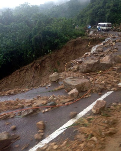 |
| Landslide eats deep into National Highway 19 of Gia Lai. Photo: Chi Dung |
By the end of the day, the rain had eased in Gia Lai but the flooding situation remained complicated in many places. National Highway 19, An Khe Pass, a 500m stretch of road in Binh Dinh province, had landslides in many places, eating deep into the road. Thousands of cubic meters of rock and soil collapsed, the concrete embankment and slopes blocking both sides of National Highway 19, An Khe Pass, and many signs were buried under the jagged rocks and soil.
There are 21 landslides on An Khe Pass, 6 of which are serious, making traffic very difficult and dangerous, with only one-way traffic. Long lines of vehicles still line up when passing through here.
Currently, the flood on rivers from Thua Thien Hue to northern Khanh Hoa is receding slowly and is still at alert level 2 to alert level 3. Particularly in the downstream of Ba River (Phu Yen), due to the flood discharge of Song Ba Ha hydroelectric reservoir, the water level is rising again.
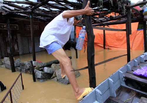 |
| Many places in the central region remain isolated. In the ancient town of Hoi An, people had to struggle to climb over fences to get to their flooded homes. Photo: Nguyen Dong |
Hydroelectric reservoirs have reduced discharge. At 9:00 p.m. on November 16, 13 hydroelectric reservoirs discharged overflow water, 6 reservoirs discharged water with a flow rate greater than 400m3/s. Specifically, Song Tranh 2 discharged 1,682m3/s; Song Ba Ha discharged 3,500m3/s; Ya Ly discharged 1,096m3/s; Se San 3 discharged 1,013m3/s; Se San 4 discharged 1,273m3/s; Se San 4A discharged 1,724m3/s.
According to VnExpress.net