A glimpse of Thong Thu...
(Baonghean) -At this time, Thong Thu - a remote area in the mountainous district of Que Phong has become an interesting destination with the presence of the Hua Na Hydropower project creating a new, majestic landscape, in harmony with nature, villages and human activities. And as always, the new also contains new "confessions and feelings"...
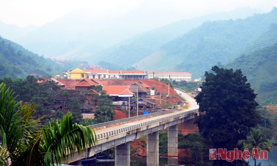 |
| Panoramic view of Thong Thu commune center (viewed from Thong Thu Border Guard Station). |
...We followed National Highway 48 to Phu Phuong intersection (Tien Phong commune, Que Phong district), turned right, and traveled about 30 kilometers along the extended National Highway 48, reaching Thong Thu after Dong Van commune. The final stop was border marker 363, close to the land belonging to Vieng Phan village cluster, Xam Tay district, Hua Phan province of Laos.
Thong Thu has 13 villages, 1,081 households, 4,563 people including 3 ethnic groups Kinh, Thai, Tho, of which 99% are Thai people. Along both sides of the main road, the resettlement areas of Pu Sai Cang, Na Luom, Huoi Dua, Na Hum, Huoi Sai... are lined with wooden stilt houses, bearing the distinctive architectural features of the highland people. Together with schools, clinics, headquarters, electricity, water invested in by the State... all create highlights in the majestic green space of Pu Hoat mountains and forests.
In Loc village (the center of Thong Thu commune), together with the Chairman of the People's Committee of the commune, Luong Thi Hong, we were helped by the staff of the Pu Hoat Nature Reserve Management Board to satisfy our desire to visit and enjoy the vastness of thousands of hectares of water surface of Hua Na Hydroelectric Lake, to better understand the connection of this large-scale hydroelectric project with the mountains and forests, and the people here. According to the design, the reservoir of the Hua Na Hydroelectric Plant is over 5,300 square kilometers wide. According to the staff of Pu Hoat Nature Reserve, the lake is thousands of hectares wide, the "nooks and crannies" of water created by the junctions of the mountains where the Chu River rises have become unique islands, and you can't go around them by motorboat all day. On the clear, calm water surface of Hua Na Hydroelectric Lake, the scenery of Thong Thu is even more beautiful. The islands are one after another on the water, the floating boat "houses" made of bamboo and thatch of the fishermen, the dry trees with many shapes on the lake, the white storks flying sideways, the rows of trees, the rice fields... and even the slopes of land eroded by floods are like ink paintings, wild, lonely, mysterious...
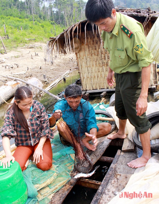 |
| Officials of Thong Thu commune and Pu Hoat Nature Reserve visited a fish cage farming household on Hua Na Hydropower Reservoir. |
The natural landscape is like that, and although "Hua Na Hydropower Reservoir is also creating jobs from fishing for about 1/4 of Thong Thu people", Commune Chairwoman Luong Thi Hong is still not very happy. In the sound of the motorboat engine, she raised her voice: "We are worried that in 2016, when the rice support period of 30 kg/person/month ends, Thong Thu people who give up their old land to the deep lake will have a very difficult time...". That is an old story and is being "talked about forever". Nearly 2 years ago, when we went to Que Phong for work, we also went to many resettlement areas in Tien Phong, Dong Van and Thong Thu to hear and see the difficulties of the people here. At that time, their daily lives also depended on the rice support from the project. The work of reclaiming fields and providing seeds and animals to develop production has almost not been carried out. People still mainly produce crops such as corn, potatoes, cassava and vegetables; Raising livestock and poultry is only based on what was there before, fragmented and small-scale... It was thought that after all this time, things would be different, but now, according to Ms. Hong, it is still the same. Thong Thu used to have nearly 140 hectares of rice fields, but after planning to build the Hua Na Hydropower Plant, there are only 61 hectares left; and up to 2,500 hectares of forestry land must be converted. Therefore, with 8 villages and 769 households resettled, the people's need for production land is great, but the investor has not organized land reclamation and land allocation...
Commune Chairwoman Luong Thi Hong confided: "It has been five years since moving to a new place, but Thong Thu people still miss their old place. Don't be quick to blame them. Even I do. Sometimes, late in the afternoon, I often go to Thong Thu bridge to look down at the lake. My old Loc village was only a short distance from the foot of the bridge, now submerged deep in water. Many nights, I dream about my old place. I see myself living with my parents and siblings in the old house like before. Then I wake up with a start, tears welling up again..." At first, I wonder if officials are like that, what about the people? But thinking back, everyone feels nostalgic about the place where the ancestral altar was kept, the village's sad and happy customs for hundreds of years. But for the sake of the nation, for the sake of a new life with many expectations for improvement, it is "must" to sacrifice. No, it is an honor to "be" able to contribute to the national project policy and people's livelihood!... That's why officials must propagate to the people to make them aware.
Suddenly excited when the motorboat glided out to the big lake, the Chairman of the People's Committee of Luong Thi Hong commune said: On the day of the relocation campaign in Na Cang village, during the meeting, an old man stood up and said, "Hong, who elected you to be the commune chairman! This land, since before you were born, has been lived by the ancestors of the villagers for generations. Why do you listen to them and chase the villagers away?..." At that time, I burst into tears and choked: "Please listen to me. I was elected as the commune chairman by you. Therefore, I have to be responsible to everyone. If you do not listen to me and insist on not relocating, when people block the Chu river, the water will rise and everyone will be in danger..." That night, I went home and cried all night. I felt helpless when I could not convince my villagers. Feeling sorry for his wife, the next morning my husband (a teacher at Thong Thu Secondary School) told the principal. They invited each other to Na Cang, along with the commune officials to campaign. Then the villagers agreed, enthusiastically carrying out the "uprooting" move...
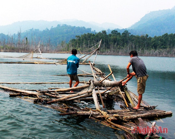 |
| Mr. Nguyen Manh Tuong fishes on Hua Na Hydroelectric Reservoir. |
We asked about the forest planting program, a content that Que Phong district is promoting to create jobs and income for people, according to the commune's Chairman Luong Thi Hong, only about 5 hectares, and is spontaneous even though there is a lot of forestry land in Thong Thu. While talking, our boat drifted down to Dong Van without us knowing. Here, as well as Thong Thu, there are quite a few people making a living by fishing on the lake... Like Mr. Nguyen Manh Tuong, residing in Bang village, Dong Van commune, and his family built a floating house, "settled" on the lake to cast nets and raise fish in cages. Talking, Mr. Tuong said: "Once or twice a day I take the boat back to the village to buy necessities, but most of the time I live on the lake to fish, earn money to support my family and wait for land allocation for production."
Understanding the lives of people in resettlement areas, therefore, the staff of Pu Hoat Nature Reserve are very interested in forest protection work. According to them, since the Hua Na Hydropower Plant dammed the Chu River, the water level rose to form a large lake, promoting the development of vegetation and aquatic species. In addition, animals moved to live there, so the biodiversity of the Reserve is increasing. Just counting the islands floating in the middle of the lake, this is the area where people used to slash and burn crops. When there was a lake, the almost abandoned fields have now grown back into forests... "In Thong Thu alone, the forest area of Pu Hoat Nature Reserve is over 29,000 hectares. Currently, about 390 people have been assigned to protect forests from 5 to 30 hectares; and they enjoy the policy of paying for forest environmental services. Having been assigned and being propagandized, people are more aware of protecting forests. However, sustainability is not high. Because the lives of people, not only Thong Thu, but also Dong Van and Tien Phong still depend heavily on forests. If we do not implement long-term sustainable job creation policies, it is easy for people to return to the forest for a living. At that time, forest protection will be extremely difficult..." - Deputy Director of Pu Hoat Nature Reserve, Mr. Le Phung Dieu worried.
At this point, we suddenly felt the excitement of exploring the majesty of Thong Thu mountains and forests calm down. We saw that, since the Hua Na Hydropower Project was built, the landscape of Thong Thu and neighboring areas had changed color. Along with the biodiversity of Pu Hoat Nature Reserve, relics and landscapes such as Sao Va waterfall, Chin Gian temple..., Que Phong district has become an interesting tourist destination, attractive enough to attract visitors. And these values must be cherished and protected. But to protect and promote these values, we must start with issues related to people's lives. We wonder whether it is fair or not when investors have not fully implemented the essential issues related to people's lives when they gave up their birthplace for the Hua Na Hydropower Project to be built. If this situation continues, will the hydropower reservoir area still be poetic, and what will the future of Pu Hoat mountains and forests be like...?!.
| Thong Thu commune, where Pu Hoat peak is nearly 2,400m high, is located in the Pu Hoat mountain range, along with Phu Xai Lai Leng in Ky Son, the roof of the North Central region. The natural area of Thong Thu commune is 41,618 hectares, accounting for more than 20% of the total area of Que Phong district; it has 29.5 km of border with Laos. To the north, Thong Thu borders Bat Mot commune, Thuong Xuan district, Thanh Hoa; to the south, it borders Hanh Dich and Tien Phong communes; to the east, it borders Dong Van commune; and to the west, it borders Vieng Pan village cluster, Xam Tay district, Hua Phan province (Laos). |
Nhat Lan - Dao Tuan