Storm level 8 is entering the East Sea
Currently, a storm is active in the sea off the central Philippines and has the international name Kalmaegi.
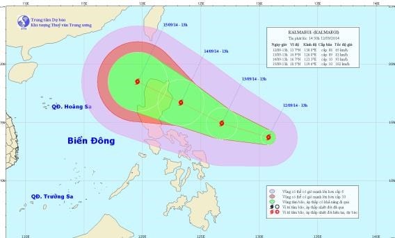 |
| Location and direction of movement of typhoon Kalmaegi. |
At 1:00 p.m. on September 12, the center of the storm was located at approximately 13.7 degrees North latitude; 130.8 degrees East longitude, approximately 730 km east of the central coast of the Philippines. The strongest wind near the center of the storm was at level 8 (62 to 74 km per hour), gusting to level 9 and 10.
It is forecasted that in the next 24 hours, the storm will move in the direction between West and West Northwest, traveling about 15 - 20km per hour and is likely to strengthen. At 13:00 on September 13, the center of the storm was at about 14.9 degrees North latitude; 126.8 degrees East longitude, about 540 km southeast of Luzon Island (Philippines). The strongest wind near the center of the storm is at level 8, level 9 (ie from 62 to 88 km per hour), gusting to level 10, level 11.
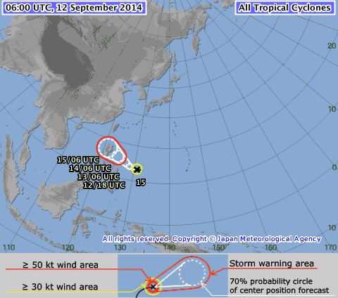 |
| Typhoon track map from Japan Meteorological Agency. |
During the next 24 to 48 hours, the storm will move in a West-Northwest direction, traveling about 15-20km per hour and will continue to strengthen. At 1:00 p.m. on September 14, the center of the storm was located at about 16.7 degrees North latitude; 123.3 degrees East longitude, in the sea east of Luzon Island (Philippines). The strongest winds near the center of the storm are at level 9, level 10 (ie from 75 to 102 km per hour), gusting to level 11, level 12.
During the next 48 to 72 hours, the storm will move in a West-Northwest and Northwest direction, traveling about 15-20 km per hour.
The development of this storm is still very complicated. If this storm passes the Philippines into the East Sea, it will become the third storm this year.
According to infonet