

Typhoon No. 1 hits Nam Dinh and Ninh Binh provinces.
With maximum wind speeds of 90 km/h, the storm toppled many trees and power poles. Post-storm rain may last 1-2 days, posing a risk of flooding in many areas of Northern Vietnam and Thanh Hoa province.
As it approached land, Typhoon Mirinae slowed down more than expected. By 10 PM on July 27th, the eye of the storm made landfall in the provinces of Nam Dinh and Ninh Binh with maximum wind speeds of 90 km/h (level 9).
In the coastal district of Giao Thuy (Nam DinhThe wind was strong and constantly changing direction, toppling many trees and tearing down several billboards. The rain came in bursts, sometimes pouring down, sometimes stopping abruptly. Most people, having heard about the storm, had closed their doors, so the streets were deserted.
Earlier, while fleeing the storm, two fishing boats belonging to fishermen from Nam Dinh were sunk by waves.Ba Lạt estuary, near Quất Lâm town."The fishermen managed to escape and swam safely to shore," he said.Pham Dinh Nghi, Chairman of the Provincial Information Office.
Video: Stormy weather in Giao Thuy district, Nam Dinh province.
Chairman of the Provincial People's CommitteeNinh BinhMr. Dinh Van Dien was still directing flood and storm prevention efforts in Kim Son district at 9 PM.The authorities are required to intensify patrols and guard duties to ensure the safety of dikes, dams, and critical points according to the approved plan.
The district is experiencing rain and strong winds of force 7-9. "No casualties or property damage have been reported in Ninh Binh province so far," a provincial leader said.
 |
Many trees have fallen on Hoang Cong Chat Street in Thai Binh City due to strong winds and storms. Photo: Nguyen Hau. |
Located right next to the eye of the storm, the provincePeaceAt 11 PM, there was strong wind and heavy rain.In waves, many trees with a diameter of 20 cm in Thai Binh city fell. Several power poles also toppled, forcing authorities to cut off the power supply to ensure safety.
InThanh HoaFrom 9 PM onwards, many areasThere was rain and strong winds. In Nga Son district, the wind blew off the roof tiles of some houses, forcing residents to evacuate immediately during the night.
The meteorological agency forecasts that Thanh Hoa will continue to experience heavy rain in the next 12-24 hours, with a total rainfall of approximately 100-200 mm, and over 200 mm in some areas. Rivers will experience a flood surge, with water levels rising by about 2-5 meters in the upper reaches and 1-3 meters in the lower reaches.
"The risk of flash floods, landslides in mountainous areas, and localized flooding in low-lying areas in Thanh Hoa is very high," a meteorological expert warned..
Located far from the storm's center, at 10 PM atHai PhongThe wind started to blow.The rain intensified, pouring down in torrents. The streets were deserted, except for a few tractor-trailer trucks carrying goods in and out of the port.
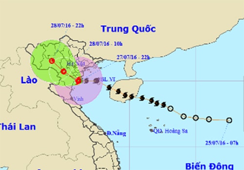 |
The blue and purple shadows indicate the predicted path of the storm. Photo: NCHMF. |
By 24:00, after entering Nam Dinh and Ninh Binh provinces, the first storm of the year had weakened and continued to move further inland. No casualties have been reported in localities such as Nam Dinh, Ninh Binh, and Thai Binh.
HanoiLocated within the storm's affected area, wind started blowing from 1 PM; heavy rain began at 10 PM and then stopped. From midnight onwards, heavy rain continued.
According to Mr. Le Vu Quang Suong, Deputy General Director of Hanoi Drainage Company, if rainfall exceeds 100 mm for 2 hours, Hanoi will experience 16 seriously flooded areas in 8 central districts.The concern is that the storm will cause widespread heavy rain in the North, potentially leading to rising water levels in major rivers such as the Nhue, To Lich, and Red River, making drainage in urban areas difficult.
 |
The storm toppled many trees. Photo: Nguyen Hau. |
Formed from a tropical depression in the East Sea, Typhoon Mirinae then moved rapidly northwest, crossing Hainan Island (China) and entering the Gulf of Tonkin this morning, reaching level 9 intensity.
This is the first storm in the East Sea this year. Prior to this, there were four tropical depressions, but none affected the Vietnamese mainland. The meteorological agency stated that this year's storms are arriving late, and the number of storms and tropical depressions affecting Vietnam will be significantly lower than the multi-year average, around 4-5 storms.
According to VNE
| RELATED NEWS |
|---|
| RELATED NEWS |
|---|