

Typhoon No. 4 is heading towards the sea off Nghe An province.
(Baonghean.vn) - The center of Typhoon No. 4 is located approximately 150km from Hainan Island (China). The strongest winds near the center of the typhoon are at level 8, with gusts of level 9-10.
How to prepare and store food during the rainy season.
How to prevent 6 diseases that are likely to break out after storms and heavy rain.
"Golden tips for driving in stormy weather."
According to the National Center for Hydro-Meteorological Forecasting: At 4:00 AM on July 24th, the center of Typhoon No. 4 was located approximately 150km southeast of Hainan Island (China). The strongest winds near the center of the typhoon were at level 8 (60-75km/h), with gusts of level 9-10.
The forecast for the next 24 hours indicates the storm will move slowly in a west-northwest direction, traveling approximately 5 km per hour.
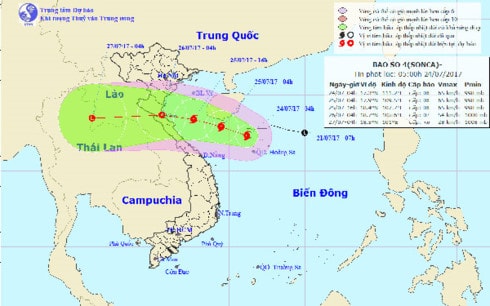 |
| Path of Typhoon No. 4 |
As of 4:00 AM on July 25th, the storm's center was located just south of Hainan Island (China). The strongest winds near the storm's center reached level 8 (60-75 km/h), with gusts of level 9-10.
Over the next 24 hours, the danger zone (strong winds of force 6 or higher, rough seas) will be from latitude 16.50N to 20.50N; west of longitude 113.00E. Near the center of the storm, winds will be strong at force 8, gusting to force 9-10, with waves 3-5 meters high and very rough seas.
Over the next 24 to 48 hours, the storm will move west-northwest at approximately 15 km per hour, making landfall in the provinces from Thanh Hoa to Quang Binh and weakening into a tropical depression.
As of 4:00 AM on July 26th, the center of the tropical depression was located over land in the provinces from Thanh Hoa to Quang Binh.
The strongest winds in the area near the center of the tropical depression are at force 6-7 (40-60 km/h), with gusts up to force 8-9.
From July 25th, in the Gulf of Tonkin (including Bach Long Vi island district), winds will gradually strengthen to level 6, in the southern part of the Gulf of Tonkin winds will reach level 7, and in areas near the storm's center, winds will reach level 8, gusting to levels 9-10. Sea waves will be 3-5m high, and along the coast of provinces from Thanh Hoa to Quang Binh, waves will be 2-3m high. The sea will be rough.
Over the next 48 to 72 hours, the tropical depression will move mainly westward, at a speed of approximately 20 km per hour.
Throughout the day and night of July 24th, there will be rain in the provinces from Quang Binh to Quang Ngai. From tomorrow (July 25th), due to the influence of the storm, the provinces from Thanh Hoa to Thua Thien Hue will experience heavy to very heavy rain (100-250mm over the entire period).
From late afternoon and night of July 25th, moderate to heavy rain (50-150mm total) is expected in the Northern Delta, Hoa Binh, Son La provinces, and the Northern Central Highlands.
In the central and southern South China Sea (including the waters around the Spratly Islands), and the sea area from Ninh Thuan to Ca Mau, there will be showers and thunderstorms, strong southwest winds of level 5, sometimes level 6, gusting to level 7-8, and rough seas.
Scattered showers and thunderstorms are expected in the area from Ca Mau to Kien Giang and the Gulf of Thailand. Tornadoes and strong gusts of wind (level 6-8) are possible during thunderstorms.
Weather forecast for areas across the country:
Northwestern region:Cloudy with scattered showers and thunderstorms in some areas. Light wind. Humidity from 65 - 95%. Lowest temperature: 23 - 26 degrees Celsius. Highest temperature: 31 - 34 degrees Celsius, with some areas exceeding 34 degrees Celsius.
Northeastern Vietnam:Cloudy during the day with scattered showers and thunderstorms; cloudy at night with showers and scattered thunderstorms. Light wind. Humidity from 60 - 97%. Lowest temperature: 24 - 27 degrees Celsius. Highest temperature: 32 - 35 degrees Celsius.
Thanh Hoa - Thua Thien Hue:During the day, the northern region (from Thanh Hoa to Ha Tinh) will have variable cloud cover with scattered showers and thunderstorms; the southern region will be mostly cloudy with showers and scattered thunderstorms; at night, it will be mostly cloudy with rain, some areas experiencing moderate to heavy rain and scattered thunderstorms. Winds will be from the west to southwest at speeds of 2-3. During thunderstorms, there is a possibility of squalls, tornadoes, and strong gusts of wind. Humidity will range from 60-99%. The lowest temperature will be 24-27°C. The highest temperature will be 31-34°C.
Da Nang to Binh Thuan:In the north, it will be mostly cloudy with showers and scattered thunderstorms; in the south, the weather will be changeable with showers and thunderstorms in some areas. Southwesterly winds will be at level 2-3. During thunderstorms, there is a possibility of squalls, tornadoes, and strong gusts of wind. Humidity will range from 58-95%. The lowest temperature will be 24-27°C. The highest temperature will be 31-34°C.
Central Highlands:Cloudy, with scattered showers and thunderstorms in some areas; rain, showers and scattered thunderstorms in the late afternoon and evening. Southwest wind at 2-3 Beaufort scale. Tornadoes, waterspouts and strong gusts of wind are possible during thunderstorms. Humidity from 67 - 97%. Lowest temperature: 21 - 24°C. Highest temperature: 27 - 30°C.
Southern Vietnam:Cloudy, with scattered showers and thunderstorms in some areas, scattered showers and thunderstorms in the late afternoon and evening. Southwest wind at 2-3 Beaufort scale. There is a possibility of squalls, tornadoes, and strong gusts of wind during thunderstorms. Humidity from 69 - 97%. Lowest temperature: 25 - 28°C. Highest temperature: 30 - 33°C.
Hanoi:Cloudy with scattered showers and thunderstorms in some areas during the day; cloudy with showers and scattered thunderstorms in the evening and night. Light wind. Humidity from 60 - 95%. Lowest temperature: 24 - 27 degrees Celsius. Highest temperature: 32 - 35 degrees Celsius.
PV
| RELATED NEWS |
|---|