People can avoid flooding with smartphones
Through the UDI Maps application on smartphones, people can receive information about rainfall, flooding or high tide developments.
The Flood Information Transmission Application (UDI Maps) developed by the Ho Chi Minh City Urban Drainage Company Limited has just been deployed on the iOS operating system for mobile devices (after testing on the Android operating system).
After successfully downloading and installing the UDI Maps software, users can know the amount of rainfall, the current situation as well as the forecast of the possibility of flooding due to rain on the roads, the development of high tides in the area and also flood images through flood surveillance cameras. From there, people can choose for themselves a reasonable and safe way to move during the rainy season.
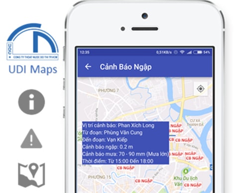 |
| Flood warning information on the app. |
According to the software developer, information on rain, high tides and flooding will be recorded from a system of automatic measuring stations and patrolling staff throughout the area. This information will be transmitted to the system for processing and correction before being put into the application.
Early flood forecast information will be calculated from the drainage hydraulic model based on rain and tide forecast information. In addition, this application also helps users choose the right direction to avoid flooding through the route finding function. Users only need to enter the starting address and destination, the phone screen will display the route image and specific route instructions.
In addition, UDI Maps also allows users to provide information about flooded areas by uploading images and information to the software. People can also provide information and reflect on the situation related to drainage problems in the city.
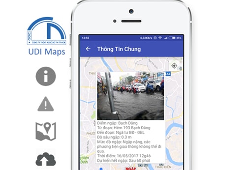 |
| Information about flooded areas. |
Traffic jams and flooding are two problems that Ho Chi Minh City residents often face every day when going out. With the increasing number of smartphone users, the city's authorities have built and deployed software to help people quickly grasp information about traffic jams and flooding so that they can proactively handle them.
Previously, the Saigon River Tunnel Management Center deployed a traffic jam avoidance application on smartphones to help people know which roads are congested so they can choose the appropriate route, and provide information about parking lots and public restrooms in real time.
According to VNE
| RELATED NEWS |
|---|