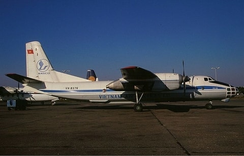
Which reconnaissance aircraft will Vietnam use instead of An-30?
Vietnam's Antonov An-30B geodetic reconnaissance aircraft have all been retired due to their expiration date.
According to some foreign reports, Vietnam once had in service a total of 8 Antonov An-30s, including the military version An-30B and the civil variant An-30A.
The An-30 (NATO reporting name Clank) is an aircraft designed for aerial mapping, photo reconnaissance and passenger transport, developed by the Antonov Design Bureau based on the An-24 and An-26 models.
The An-30 is considered an improvement over the An-24T, it has a completely new front fuselage with a glass nose and a control compartment 41 cm higher than the fuselage, the cockpit has a hump shape similar to the Boeing 747.
The easiest way to distinguish between the An-30A and An-30B is that the passenger version does not have a "lump" right under the cockpit glass. Vietnam's An-30s were originally in the air force but were later transferred to the civilian side.
 |
| An-30B aerial reconnaissance aircraft owned by Vietnam Air Services Company (VASCO). |
The An-30 made its first flight on August 21, 1967, officially launched in July 1968, and was mass-produced between 1971 and 1980 with a total of 123 aircraft manufactured in all variants.
The aircraft is 24.26 m long; 29.2 m wingspan; 8.32 m high; take-off weight 23 tons.
The heart of the An-30 is two ZMKB Progress AI-24T turboprop engines with a capacity of 2,103 kW (2,803 ehp) each, giving a maximum speed of 540 km/h, a cruise speed of 430 km/h, a ceiling of 8,300 m, and a range of 2,630 km.
The An-30 is equipped with four geodetic cameras with flaps that allow the use of lasers, thermal imaging, gravimetric analysis, magnetometry and other geodetic instruments. For continuous and accurate geodetic flights, the standard equipment for the An-30 includes computer flight control technology.
The An-30's crew of 7, the surveyor sits in a glass cabin with a very good field of view, and can even perform reconnaissance missions with the naked eye when the aircraft operates at low altitude.
 |
| UAV GeoScan 101 serial number 10126 of the Vietnam Army. |
After the An-30s had to retire, for quite a long time the Vietnam People's Army had a lack of aerial reconnaissance to serve the geodetic work of creating military terrain maps.
But with the development of science and technology, the role of the heavy An-30 has been replaced by small, lightweight drones with low operating costs but with many outstanding features.
To meet the mission requirements in the new situation, the Department of Cartography - General Staff has put into operation remote sensing UAVs to serve the work of creating 3D digital military terrain maps.
In the reports broadcast on the National Defense Television channel, images of the GeoScan 101 UAV produced by the GeoScan company based in St. Petersburg, Russia were introduced.
The special feature of this drone, which is used for military topographic mapping or aerial remote sensing measurements, is the high level of automation in all operations, from flight planning to final data export thanks to the pre-installed Agisoft PhotoScan Pro software.
Obviously, the Geoscan 101 UAV above can be considered an excellent descendant, not only worthy of inheriting the glorious achievements of the An-30 but also bringing it to a new level.
According to Baodatviet
| RELATED NEWS |
|---|
