Warning: Nghe An at high risk of landslides and flooding
(Baonghean.vn) - It is forecasted that in the next 3-6 hours, Nghe An province will continue to have rain, with rainfall reaching 20-40mm. Warning of high risk of landslides and flooding in low-lying areas in Nghe An province, especially in Yen Thanh, Do Luong and Thanh Chuong districts.
Currently:Through monitoring on satellite cloud images, radar images, lightning location images, it shows that there is a convective cloud area over Nghe An province. Rainfall in the past 3 hours in Hong Son 64.6mm, Thanh Huong 41.4mm, Thanh Thuy 38.4mm, My Son 51mm.
It is forecasted that in the next 3-6 hours, Nghe An province will continue to have rain, with rainfall reaching 20-40mm.
Warning:In the next 3-6 hours, there is a high risk of landslides and flooding in low-lying areas in Nghe An province, especially in Yen Thanh, Do Luong and Thanh Chuong districts.Disaster risk level: Level 1.
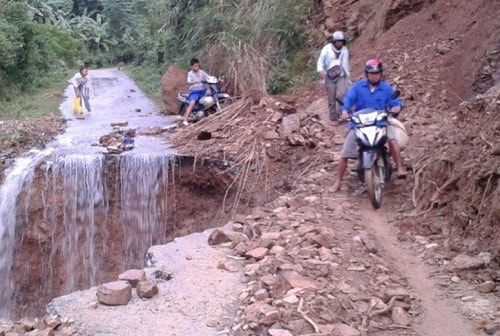 |
| Warning of high risk of landslides and flooding in Yen Thanh, Do Luong, Thanh Chuong districts (Nghe An). Illustrative photo |
WIDESPREAD STORM NEWS
1. Widespread thunderstorms in the North and North Central regions:
Due to the influence of the tropical convergence zone passing through the North Central region, last night (July 9), there continued to be widespread showers and thunderstorms in the Northern Delta and North Central regions.
Currently (10/7):The tropical convergence zone has an axis passing through the North Central region.
Forecast:During the day and night today (July 10), in the Northern Delta and North Central regions there will be rain, some places will have moderate rain, heavy rain and thunderstorms.
Weather in Hanoi area today and tonight:Showers and thunderstorms at times.
2. Warning of moderate and heavy rain in the Central Central, Central Highlands and Southern regions:
Currently:The tropical convergence zone has an axis passing through the North Central region, the southwest monsoon operates with strong intensity.
Due to the influence of the tropical convergence zone combined with the southwest monsoon continuing to operate strongly, from now until July 12, in the provinces from Quang Tri to Phu Yen, the Central Highlands and the South, there will be rain, moderate rain, heavy rain to very heavy rain and strong thunderstorms. During the thunderstorms, there is a possibility of tornadoes, whirlwinds and strong gusts of wind.Disaster risk level due to heavy rain: level 1.
WARNING FOR STRONG WINDS AND HIGH WAVES AT SEA
Currently (10/7):Due to the influence of the tropical convergence zone with its axis passing through the North East Sea combined with the strong southwest monsoon, thunderstorms are causing rain and thunderstorms in the East Sea area (including Hoang Sa and Truong Sa archipelagos), the sea area from Binh Thuan to Ca Mau; in the South East Sea area (including Truong Sa archipelago) and the sea area from Binh Thuan to Ca Mau, there are strong southwest winds of level 6, gusting to level 7-8; rough seas.
Forecast:Due to the influence of the tropical convergence zone with its axis passing through the North East Sea combined with the strong southwest monsoon, in the East Sea area (including Hoang Sa and Truong Sa archipelagos), the sea areas from Binh Thuan to Ca Mau, Ca Mau to Kien Giang and the Gulf of Thailand continue to have heavy thunderstorms. During the thunderstorms, there is a possibility of tornadoes and strong gusts of wind.
In the South China Sea (including Truong Sa archipelago) and the sea area from Binh Thuan to Ca Mau, there will continue to be strong southwest winds at level 6, gusting to level 8, waves 2-4m high; rough seas.Disaster risk level: level 1.