Latest information on nearshore tropical depression and storm No. 3 in the East Sea
(Baonghean.vn) - According to the National Center for Hydro-Meteorological Forecasting, in the next 24 to 48 hours, storm No. 3 - storm Son-Tinh will continue to move rapidly in a westerly direction, traveling about 25-30km per hour, directly affecting the coastal provinces of the Northeast, the Northern Delta and the North Central region.
Tropical Depression News Nearshore:
10 o'clock, the center of the tropical depression is located at about 18.2 degrees North latitude; 107.0 degrees East longitude, right on the sea of provinces from Nghe An to Quang Binh. The strongest wind near the center of the tropical depression is level 6 (40-50km/hour),level 8 jerk. The range of strong winds of level 6, gusting to level 8 is about 50km from the center of the tropical depression.
Forecast for the next 12 hours,The tropical depression moved slowly in the West-Southwest direction at about 5km per hour and gradually weakened into a low-pressure area. By 10pm on July 17, the center of the low-pressure area was at about 18.1 degrees North latitude; 105.9 degrees East longitude, on the mainland of Nghe An, Ha Tinh, and Quang Binh provinces. The strongest wind near the center of the low-pressure area decreased to below level 6 (below 40km/h).
Due to the influence of a tropical depression, today (July 17) in the Gulf of Tonkin, there will continue to be showers and thunderstorms, with strong winds of level 6.level 8 jerk, waves 2-3m high. Rough sea.Disaster risk level due to near-shore tropical depression: level 3.
Besides, due to the influence of the tropical convergence zone combined with the strong southwest monsoon, during today and tonight, in the East Sea (including the waters of Hoang Sa and Truong Sa archipelagos), the waters from Binh Thuan to Ca Mau, Ca Mau to Kien Giang and the Gulf of Thailand will continue to have heavy thunderstorms. During thunderstorms, there is a possibility of tornadoes and strong gusts of wind.
The Central and Southern East Sea (including the Truong Sa archipelago), the sea area from Binh Thuan to Ca Mau during the day and tonight will continue to have strong southwest winds of level 6, sometimes level 7, gusting to level 9, waves from 2-4m high; rough seas.Disaster risk level due to strong winds and big waves: level 1.
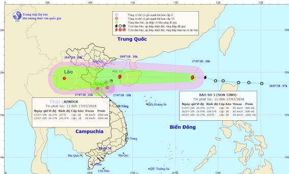 |
| Location and path of the storm. Photo: National Center for Hydro-Meteorological Forecasting |
STORM NEWS IN THE EAST SEA - STORM NO. 03 (SON-TINH):
This morning,After entering the North East Sea, the tropical depression strengthened into a storm, storm number 03 in 2018 (international name: Son-Tinh).
10 o'clock, the center of the storm is located at about 19.4 degrees North latitude; 117.0 degrees East longitude, about 680km east of Hainan Island. The strongest wind near the center of the storm is level 8 (60-75km/hour),level 10.
Forecast for the next 24 hours, the storm moved very quickly in the West Northwest direction, traveling about 35km per hour. At 10:00 on July 18, the center of the storm was at about 19.5 degrees North latitude; 108.5 degrees East longitude, in the Gulf of Tonkin, about 270km east of the coast of the provinces from Hai Phong to Ha Tinh. The strongest wind near the center of the storm was level 8 (60-75km/hour).level 10. The range of strong winds of level 6, gusting to level 8 or higher is about 100km from the center of the storm.
Due to the influence of the storm, in the North East Sea area (including the waters of Hoang Sa archipelago), there are heavy thunderstorms; storm winds gradually increase to level 8,level 10; rough seas. In the Gulf of Tonkin from early morning and tomorrow (July 18), there will be strong winds of level 6-7, near the center of the storm will be strong winds of level 8, gusts of level 10, waves 4-6m high. Rough seas.
Dangerous areas in the East Sea in the next 24 hours: (strong wind level 6 or higher) from latitude 17.5 to 21.5 degrees North; east of longitude 106.0 degrees East.
Forecast for the next 24 to 48 hours, the storm continues to move rapidly to the West, about 25-30km per hour, directly affecting the coastal provinces of the Northeast, the Northern Delta and the North Central region, then weakening into a tropical depression.
At 10:00 a.m. on July 19, the center of the tropical depression was at about 19.3 degrees North latitude; 102.0 degrees East longitude, in the Central Laos region. The strongest wind near the center of the tropical depression was level 6 (40-50 km/h).level 7. The range of strong winds of level 6, gusting to level 7 or higher is about 50km from the center of the tropical depression.
Forecast for the next 48 to 60 hours, the tropical depression continued to move rapidly to the West, weakening and gradually dissipating.Storm disaster risk level: level 3.