Tropical depression 140 km off the North Central coast and likely to strengthen
(Baonghean.vn) - Due to the influence of the tropical low pressure circulation, on the mainland coastal provinces from Quang Ninh to Nghe An there are gusts of wind level 6-7.
According to the forecast of the National Center for Hydro-Meteorological Forecasting, at 4:00 a.m. on July 22,The center of the tropical depression is located at about 19.5 degrees North latitude; 107.2 degrees East longitude, about 140km east of the coast of the provinces from Nam Dinh to Thanh Hoa.The strongest wind near the center of the tropical depression is level 6 (40-50km/hour).level 8 jerk. The range of strong winds of level 6, gusting to level 8 is about 50km from the center of the tropical depression.
Dangerous areas at sea in the next 24 hours(strong wind level 6 or higher): the entire Gulf of Tonkin area.
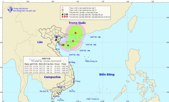 |
| Path and location of the tropical depression. Photo: National Center for Hydro-Meteorological Forecasting |
Forecast for the next 24 hours,The tropical depression is moving in the East-Northeast direction at 5-10km per hour and is likely to strengthen. At 4:00 a.m. on July 23, the center of the tropical depression was at about 20.3 degrees North latitude; 109.1 degrees East longitude, about 140km East-Northeast of Bach Long Vi island district. The strongest wind near the center of the tropical depression is level 6-7 (40-60km/hour).level 8 jerk. The range of strong winds of level 6, gusting to level 8 is about 60km from the center of the tropical depression.
Due to the influence of the tropical low pressure circulation, on the mainland coastal provinces from Quang Ninh to Nghe An there are gusts of wind level 6-7; in the Gulf of Tonkin (including Bach Long Vi and Co To island districts) there are strong winds level 6-7,level 8 jerkand there will be heavy rain and thunderstorms. Rough seas. Disaster risk level due to tropical depression in the Gulf of Tonkin: level 3.
Over the next 24 to 48 hours,Tropical depression moving in the Northeast direction, about 5km per hour.
BesidesDue to the influence of the tropical convergence zone combined with the strong southwest monsoon, during today and tonight (July 22), in the North East Sea area (including the waters of Hoang Sa archipelago), the waters from Binh Thuan to Ca Mau, Ca Mau to Kien Giang and the Gulf of Thailand, there will continue to be heavy thunderstorms.
The Central and Southern East Sea (including the Truong Sa archipelago), the sea area from Binh Thuan to Ca Mau continues to have strong southwest winds at level 6, gusting to level 8, waves 2-3m high; rough seas.Disaster risk level: level 1.
Widespread heavy rain in the North and Central regions and thunderstorms in the Central Highlands and South
Due to the influence of the strong tropical convergence zone connected with the tropical depression in the Gulf of Tonkin, last night (July 21), in the provinces of Son La, Hoa Binh, coastal and southern Northern Delta, Thanh Hoa to Thua Thien Hue, there was rain, moderate rain, some places had heavy rain to very heavy rain with common rainfall of 10-25mm; some places had over 30mm such as: Lac Son (Hoa Binh) 59mm, Kim Boi (Hoa Binh) 41mm, Dong Ha (Quang Tri) 34mm, Khe Sanh (Quang Tri) 55mm,...
Presently (July 22): The tropical convergence zone connecting with the tropical depression in the Gulf of Tonkin is moving towards the East Northeast.
Today (July 22), in the coastal areas and the Northern Delta, the provinces from Thanh Hoa to Thua Thien Hue will still have moderate to heavy rain; in Nghe An, Ha Tinh, Quang Binh, Quang Tri, some places will have very heavy rain. From tonight, heavy rain in the Northern and Central provinces will gradually decrease.
Weather in Hanoi area: Today (July 22) there will be rain and showers. From tonight the rain will gradually decrease.
The Central Highlands and the South are affected by the strong southwest monsoon, so in the next 2-3 days there will continue to be rain, some places will have moderate rain, heavy rain and thunderstorms (rain is concentrated in the afternoon and night); during thunderstorms there is a very high possibility of tornadoes, whirlwinds and strong gusts of wind.
Disaster risk level due to heavy rain: level 1; Ha Tinh and Quang Binh provinces: level 2.