Storm No. 4 is likely to strengthen and turn towards our mainland.
(Baonghean.vn) - According to the National Center for Hydro-Meteorological Forecasting, in the next 48 to 72 hours, the storm will move in a West-Southwest direction, traveling about 15km per hour. At 4:00 a.m. on August 17, the storm's center will be on land in the coastal area from Quang Ninh to Nam Dinh.
At 4:00 a.m. on August 14,The center of storm BEBINCA (storm No. 4) is located at about 20.7 degrees North latitude; 113.5 degrees East longitude, in the sea south of Guangdong province (China). The strongest wind near the storm center is level 8 (60-75km/hour),level 10. The range of strong winds of level 6, gusting to level 8 is about 90km from the center of the storm.
Forecast for the next 24 hours,The storm is moving slowly eastward and is likely to change direction to the northwest, traveling about 5km per hour and is likely to strengthen. At 4:00 a.m. on August 15, the center of the storm was at about 21.4 degrees north latitude; 112.4 degrees east longitude, in the sea south of Guangdong province (China). The strongest winds near the center of the stormstronggrant8-9(60-90km/h),level 11. The range of strong winds of level 6, gusting to level 8 is about 110km from the center of the storm.
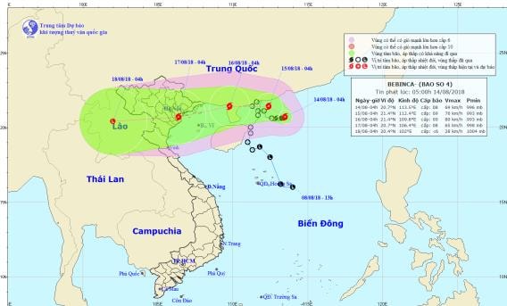 |
| Storm path and location. Photo: National Center for Hydro-Meteorological Forecasting |
Due to the influence of the storm, the North East Sea area has strong winds of level 6; the North East Sea area has stormy rain, strong winds of level 7, the area near the storm's center has strong winds of level 8, gusts of level 10. The sea is rough.
Dangerous areas in the East Sea in the next 24 hours (strong wind level 6 or higher): North of latitude 19.5 degrees North; East of longitude 110.5 degrees East.
Over the next 24 to 48 hours,The storm is moving westward at a speed of 5-10km per hour. At 4:00 a.m. on August 16, the center of the storm was located at approximately 21.4 degrees North latitude; 109.8 degrees East longitude, just north of the Leizhou Peninsula (China). The strongest winds near the center of the stormstronglevel 8-9(60-90km/h),level 11. The range of strong winds of level 6, gusting to level 8 is about 110km from the center of the storm.
During the next 48 to 72 hours,The storm is moving in a West-Southwest direction, traveling about 15km per hour. At 4:00 a.m. on August 17, the center of the storm was located at about 20.7 degrees North latitude; 106.4 degrees East longitude, on the mainland of the coastal area from Quang Ninh to Nam Dinh. The strongest wind near the center of the stormstronggrant8(60-75km/h),level 10. The range of strong winds of level 6, gusting to level 8 is about 90km from the center of the storm.Storm disaster risk level: level 3.
Heavy Rain Warning:From tonight (August 14) to August 15, there will be scattered rain in the Northeast. From the night of August 15 to August 17, there will be heavy to very heavy rain in the Northern and North Central provinces (rainfall 250-350mm/period).
In addition, due to the influence of the tropical convergence zone combined with the strong southwest monsoon, during the day and tonight (August 14), in the Central and Southern East Sea (including the waters of Truong Sa archipelago), the waters from Binh Thuan to Ca Mau will continue to have strong southwest winds of level 6-7, gusting to level 9, waves from 2-4m high; rough seas.
The Gulf of Tonkin, the sea areas from Binh Thuan to Ca Mau, Ca Mau to Kien Giang and the Gulf of Thailand will have heavy thunderstorms; there is a possibility of tornadoes and strong gusts of wind during thunderstorms.Disaster risk level due to strong winds and big waves: level 1.
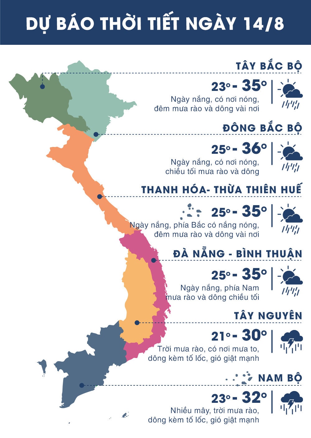 |
| Temperature on August 14 in regions across the country. Photo: news.zing.vn |