This afternoon and evening, super typhoon MANGKHUT will enter the East Sea.
(Baonghean.vn) - According to the National Center for Hydro-Meteorological Forecasting, early this morning (September 15), super typhoon MANGKHUT with gusts above level 17 made landfall in the northern area of Luzon Island (Philippines).
4:00 a.m. September 15, the center of the super storm is located at about 18.0 degrees North latitude; 121.5 degrees East longitude, in the area north of Luzon Island (Philippines). The strongest wind near the center of the super storm is level 16 (185-200km/hour).jerk above level 17.
Forecast for the next 24 hours,The super typhoon is moving in a West-Northwest direction, at about 25km per hour. Thus, around noon and afternoon this super typhoon will enter the Northeast region of the East Sea.
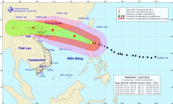 |
| Path and location of super typhoon MANGKHUT. Photo: National Center for Hydro-Meteorological Forecasting |
At 4:00 a.m. on September 16, the center of the storm was located at about 20.1 degrees North latitude; 116.1 degrees East longitude, about 610 km East Southeast of Leizhou Peninsula (China). The strongest wind near the center of the storm was level 14 (150-165 km/h).level 17; range of strong winds level 6, gusts level 8 or higher about 400km from the storm center; Range of strong winds level 10 or higher about 200km from the storm center.Disaster risk level: level 3-4.
Due to the influence of the storm, in the Northeast Sea, there will be stormy rain and winds gradually increasing to level 11-12, and in the area near the storm's center, winds will increase to level 14-15.jerk above level 17; rough seas.
Dangerous areas in the East Sea in the next 24 hours (strong wind level 6 or higher): North of latitude 15.0 degrees North; East of longitude 113.0 degrees East.
Over the next 24 to 48 hours,The storm is moving in a West-Northwest direction, traveling about 25km per hour. At 4:00 a.m. on September 17, the center of the storm was at about 21.9 degrees North latitude; 109.7 degrees East longitude, in the southeast area of Guangxi province (China). The strongest wind near the center of the storm is level 12 (115-135km/hour).level 15.Disaster risk level: level 3.
Over the next 48 to 72 hours,The storm moved in the West Northwest direction, traveling about 25km per hour, moving deep into the mainland and gradually weakening into a tropical depression. At 4:00 a.m. on September 18, the center of the tropical depression was at about 22.6 degrees North latitude; 104.0 degrees East longitude, in the northern mountainous area. The strongest wind near the center of the tropical depression was level 6,level 8 jerk.Disaster risk level: level 3, Quang Ninh province level 4.
Warning:From September 17-19, the storm circulation will cause very heavy rain in the North and North Central regions: In the Northeastern provinces from 200-300mm, in the northern mountainous areas over 300mm in some places; in the Northwestern region and Thanh Hoa from 100-200mm.