Weather November 2: Central region sunny during the day, cold at night
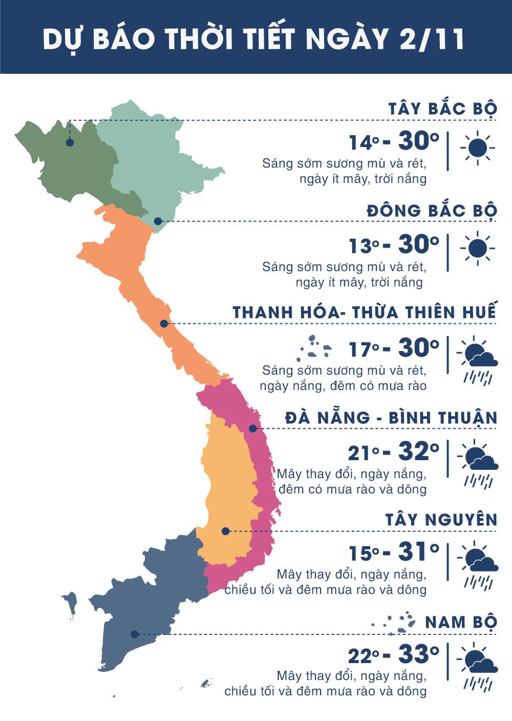
(Baonghean.vn) - According to the forecast, today, the Central provinces will be dry and sunny from early morning. The highest temperature in the area from Thanh Hoa - Thua Thien Hue will remain at 29-31 degrees, from Da Nang - Binh Thuan from 30-32 degrees.
 |
| Today, the Central provinces are dry. Photo: Archive |
Meanwhile, the entire North will have sunshine from early morning until the afternoon. The temperature difference between day and night is high, at night it will only be 17-19 degrees, in the mountains it will be around 16-18 degrees.
The state of little rain and sunny days also remains in the Central Highlands and the South. At night, the temperature in the Central Highlands remains low at 17-19 degrees, cold.
Meanwhile, in the Southeast provinces, the weather has turned cold, with the lowest temperature ranging from 19 to 22 degrees. This is the lowest temperature since the beginning of the year.
 |
| Temperature on November 2 in regions across the country. Photo: news.zing.vn |
News about storm number 7 in the East Sea:
At 4:00 a.m. on November 2, the storm center is located at about 21.1 degrees North latitude; 116.6 degrees East longitude, 650km northeast of Hoang Sa archipelago. The strongest wind near the storm center is level 8 (60-75km/hour),level 10. The range of strong winds of level 6, gusting to level 8 or higher is about 150km from the center of the storm.
Forecast for the next 24 hours,The storm moved north at a speed of 5-7km per hour and weakened into a tropical depression. At 4:00 a.m. on November 3, the center of the tropical depression was at about 22.0 degrees North latitude; 116.7 degrees East longitude, about 400km southwest of Taiwan. The strongest wind near the center of the tropical depression was level 6 (40-50km/hour).level 8 jerk. The range of strong winds of level 6, gusting to level 8 is about 50km from the center of the tropical depression.
Due to the influence of the storm, which weakened into a tropical depression, in the northeastern sea of the North East Sea there are strong winds of level 6-7, and near the storm's eye, level 8.level 10; very rough seas.
Dangerous areas in the East Sea in the next 24 hours (strong wind level 6 or higher): North of latitude 18.0 degrees North; East of longitude 115.0 degrees East.
Over the next 24 to 48 hours,The tropical depression continues to move northeast, 5-10km per hour, weakens into a low pressure area and gradually dissipates.Disaster risk levelliveNortheast East Sea area: Level 3.