Weather on August 25: Storm Bailu weakens into a tropical depression, Nghe An has heavy rain
(Baonghean.vn) - It is forecasted that in the next 24 hours, storm Bailu will make landfall in the provinces of Fujian - Guangdong (China) and then weaken into a tropical depression. Nghe An will have moderate to very heavy rain.
Weather forecast for the areas:
Northern RegionHot and sunny during the day with common temperatures from 34-37 degrees; at night there are showers and thunderstorms in some places.
Hanoi weatherThe temperature continues to increase by 2 degrees compared to yesterday, the highest is 36 degrees, hot and sunny. In the evening and at night there will be showers and thunderstorms in some places; in thunderstorms there is a possibility of tornadoes, lightning and strong gusts of wind.
Provinces from Thanh Hoa to Thua Thien HueThere is rain, locally moderate rain, heavy rain and thunderstorms. From Nghe An to Quang Tri there is moderate rain, heavy rain, some places have very heavy rain (common rainfall 50-100mm/24h, some places over 120mm/24h).The highest temperature is from 30-33 degrees, in the North some places are above 33 degrees.
Da Nang to Binh ThuanSunny day 33-36 degrees, in the South some places above 36 degrees; at night there are showers and thunderstorms in some places.
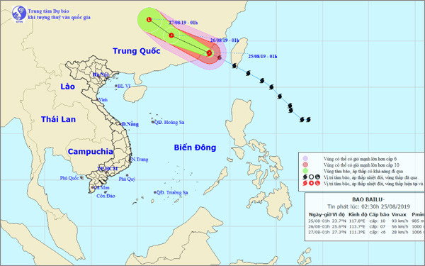 |
| Forecast path of the storm. |
Central Highlands and Southshowers and thunderstorms in some places.The highest temperature in the Central Highlands is from 28-31 degrees; in the South, it is commonly 30-33 degrees, with some places above 33 degrees. In Ho Chi Minh City, the highest is 33 degrees and in Can Tho, it is 32 degrees.
Regarding storm Bailu near the East Sea, the storm is forecast to move northwest, traveling about 25km per hour, making landfall in the provinces of Fujian - Guangdong (China).
As of 1 p.m. today, the eye of the storm was located at approximately 24.8 degrees North latitude; 115.2 degrees East longitude, on the mainland of Fujian - Guangdong - Jiangxi provinces. The strongest wind near the eye of the storm was level 8 (60-75 km/h), gusting to level 10.
In the following hours, the storm moved in a West-Northwest direction, traveling about 15-20km per hour, going deep into mainland China and weakening into a tropical depression, then a low pressure area.