Storm No. 8 continues to strengthen, moving in the West Northwest direction
The center of storm No. 8 is currently about 470km east of Hoang Sa archipelago. The strongest wind near the center of the storm is level 10, gusting to level 13. In the next 24 hours, storm No. 8 will move west-northwest, about 10km per hour, and is likely to strengthen further.
According to the National Center for Hydro-Meteorological Forecasting, at 4:00 a.m. on (October 22),Storm No. 8 center locationat about 16.5 degrees North latitude; 116.7 degrees East longitude, about 470km East of Hoang Sa archipelago. The strongest wind near the storm center is level 10 (90 - 100km/h), gusting to level 13. The radius of strong wind from level 6, gusting to level 8 or higher is about 150km from the storm center.
It is forecasted that in the next 24 hours, storm No. 8 will move in a West-Northwest direction, traveling about 10km per hour and is likely to strengthen. At 4am on October 23, the center of storm No. 8 was about 220km east-northeast of Hoang Sa archipelago. The strongest wind near the center of the storm is level 11-12 (100-135km/hour), gusting to level 14.
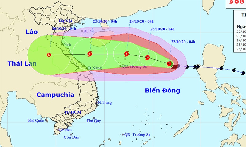 |
| Path and location of storm number 8. |
Dangerous areas due to storms in the East Sea in the next 24 hours (strong winds of level 6 or higher, gusts of level 8 or higher): From latitude 14.5 to 19.0 degrees North; from longitude 112.5 to 118.5 degrees East. All ships operating in the dangerous area are at high risk of being affected by strong gusts of wind.
Due to the influence of the storm, in the eastern sea area of the North East Sea, there will be stormy rain, strong winds of level 9 - 10, then increasing to level 11 - 12, gusting to level 14; waves from 6 - 8m high; rough seas.
In the next 24 to 48 hours, the storm will move west-northwest at 5-10km per hour and is likely to strengthen. At 4am on October 24, the storm's eye was located just north of the Hoang Sa archipelago. The strongest wind near the storm's eye is level 11-12 (100-135km/h), gusting to level 14.
During the next 48 to 72 hours, the storm will move mainly westward, at a speed of 10-15km per hour. At 4am on October 25, the storm's eye was located in the southern waters of the Gulf of Tonkin. The strongest winds near the storm's eye are at level 8-9 (60-90km/h), gusting to level 11.
Many areas in the East Sea have heavy thunderstorms
Also according toNational Center for Hydro-Meteorological ForecastingCurrently, in the sea area from Binh Thuan to Ca Mau, Ca Mau to Kien Giang, the Central and Southern East Sea area (including the sea area of Truong Sa archipelago) there are thunderstorms, the sea area east of the Northern East Sea area is having storms. The Northeast wind in the Gulf of Tonkin is strong at level 6, gusting to level 8, rough seas.
It is forecasted that during the day and tonight (October 22), due to the influence of cold air combined with the tropical convergence zone connected to storm No. 8, there will be heavy thunderstorms in the sea areas of the provinces from Binh Thuan to Ca Mau, Ca Mau to Kien Giang, the Gulf of Thailand, the eastern part of the central East Sea, the southern East Sea (including the sea area of Truong Sa archipelago); the eastern sea area of the northern East Sea will have storms. There is a possibility of tornadoes and strong gusts of wind during the storm.
In the North East Sea (including the Hoang Sa archipelago), there are strong winds of level 7 - 8, especially in the Eastern sea, strong winds of level 9 - 10, then increasing to level 11 - 12, gusting to level 14; waves 6 - 8m high; rough seas. In the Gulf of Tonkin and the sea off the coast of the provinces from Quang Tri to Ninh Thuan, there are strong northeast winds of level 6, gusting to level 8; waves 2 - 4m high; rough seas.