Nghe An issues telegram to respond to storm No. 9
(Baonghean.vn) - On the morning of October 27, the Steering Committee for Natural Disaster Prevention and Search and Rescue of Nghe An province issued Official Dispatch 39/CD-UBND on focusing on responding to storm No. 9.
To proactively respond to storms and floods, limit damage to people's lives and property, the Chairman of the People's Committee - Head of the Provincial Steering Committee for Natural Disaster Prevention and Search and Rescue (PCTT - TKCN) requests the Chairman of the People's Committee - Head of the PCTT - TKCN Steering Committee of districts, cities and towns; the Provincial Military Command; the Provincial Border Guard Command, the Provincial Police; the Departments of: Transport, Construction, Education and Training, Health, Culture, Sports, Natural Resources and Environment, Agriculture and Rural Development, Industry and Trade, Tourism, Information and Communications; Chairman of the Board of Members, Chairman of the Company, Director of Irrigation Companies; Hydropower in the province and related units to implement a number of tasks.
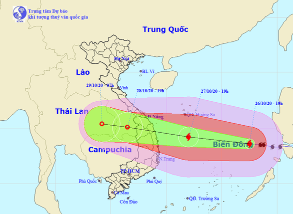 |
| Forecast of the path of storm No. 9. Photo: National Center for Hydro-Meteorological Forecasting |
For sea and coastal routes
Ensuring safety of activities at sea and on islands: Localities coordinate with border guards, fisheries sector, transport sector and families of ship owners to continue to focus on, check and count ships and means of transport operating at sea (including transport ships and tourist ships), guide them to move out and not enter dangerous areas or to safe shelters; Dangerous areas due to storms in the East Sea in the next 24 hours (strong winds from level 6 or higher, gusts from level 8 or higher): From latitude 11.0 to 18.0 degrees North latitude; west of longitude 118.5 degrees East longitude. All ships and boats operating in dangerous areas are at high risk of being affected by strong gusts of wind.
Check the evacuation plan for people, coastal areas, and river mouths according to the approved plan.
For the mountains
Closely monitor forecasts and warnings about storms, heavy rains, floods, flash floods and landslides; Provide timely information to villages and hamlets so that authorities and people know and proactively prevent; Authorities at all levels are ready to deploy approved plans to evacuate people in areas at risk of landslides and households living along rivers and streams to ensure the safety of people's lives and property.
Inspect and review irrigation and hydroelectric reservoirs, especially for critical reservoirs and projects under construction, proactively operate to receive floods, ensure safety of projects and downstream areas. Organize information and warnings for authorities and people in affected downstream areas about flood discharge operations, especially in emergency flood discharge situations to proactively prevent and avoid.
Check, review, and prepare plans to ensure safety of mines and tunnels; arrange forces, materials, machinery, and equipment to be ready to respond and handle situations when they arise.
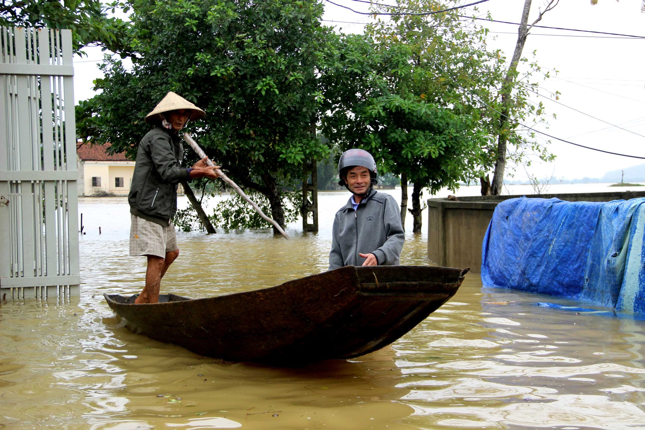 |
| Floods caused damage to Chau Nhan commune (Hung Nguyen) on October 18. Photo courtesy of QA |
Strictly manage and guide traffic at ferry terminals; traffic routes, culverts, and spillways that are flooded or eroded; set up markers, assign people to be on duty, guard, block roads, divide traffic, and guide traffic to ensure absolute safety for people and vehicles participating in traffic.
For the plains
Check and deploy patrol and guard plans to ensure the safety of dikes according to alarm levels and irrigation works and dikes under construction. Prepare forces, means and materials to handle incidents at works according to the "4 on-site" motto.
Check the safety and operation of works in irrigation systems, proactively drain buffer water to prevent flooding, and deploy plans to protect agricultural production.
Check and review plans and be ready to evacuate residents in low-lying areas and river mouths.
Rescue agencies and units are ready with forces and means to proactively rescue when requested.
The urgent dispatch also requested that Departments, Boards and sectors, according to their state management functions and assigned tasks, proactively coordinate with localities to deploy storm response measures according to the "4 on-site" motto, and be ready to support localities when requested.
Provincial Radio and Television Station, Nghe An Newspaper, Ben Thuy Coastal Information Station and other mass media increase broadcasting time, report on developments of storms and heavy rains so that authorities at all levels and people can proactively prevent...
Storm No. 9 is moving rapidly towards the mainland of our country. At 7:00 a.m. on October 27, the center of the storm was at about 13.5 degrees North latitude; 114.8 degrees East longitude, about 230km North-Northeast of Song Tu Tay Island. The strongest wind near the center of the storm is level 14, gusting to level 17. It is forecasted that in the next 24 hours, the storm will move in a West-Northwest direction, traveling 20-25km per hour.
Although Nghe An is far from the center of storm No. 9, from the evening and night of October 27, due to the influence of the northern circulation of storm No. 9 combined with cold air, the sea area of Nghe An province has northeast winds of level 8, level 9, gusting to level 10, level 11; very rough seas; waves from 4 to 6m high. Coastal areas of Nghe An province are likely to experience storm surges from 0.5 to 0.7m high. In particular, in the south of Nghe An, there will be a period of heavy rain lasting from October 28 to October 31, 2020, with total rainfall ranging from 200 to 400 mm/period and in some places over 500 mm/period.