Storm No. 8 weakens into a tropical depression, Nghe An has heavy rain
(Baonghean.vn) - It is forecasted that in the next 12 hours, the tropical depression will move quickly to the West, traveling 20-25km per hour, weakening into a low pressure area and entering the Thanh Hoa and Nghe An areas.
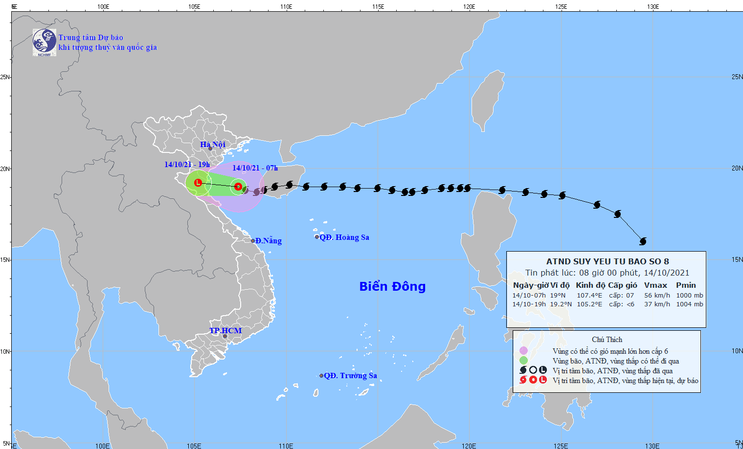
According to the latest forecast of the North Central Region Hydrometeorological Station, last night (October 13),storm number 8has entered the Gulf of Tonkin, rapidly weakening in intensity. This morning, the storm continued to weaken into a tropical depression.
Due to the influence of storm number 8So at Bach Long Vi island station, there were strong winds of level 9, gusting to level 11, at Co To island station, there were strong winds of level 7, gusting to level 9, at Cua Ong there were strong winds of level 6, gusting to level 9. In the North Central region, there was heavy rain from 50-150mm.
At 7:00 a.m. on October 14, the center of the tropical depression was at about 19.0 degrees North latitude; 107.4 degrees East longitude, about 220km from Thanh Hoa, about 230km from Nghe An, about 200km from Ha Tinh. The strongest wind near the center of the tropical depression was level 6-7 (40-60km/h), gusting to level 9. The radius of strong winds from level 6, gusting to level 8 or higher was about 150km from the center of the tropical depression.
Forecast for the next 12 hours,The storm moved rapidly westward, traveling 20-25km per hour, and weakened into a tropical depression. At 4:00 p.m. on October 14, the center of the tropical depression was at about 19.0 degrees North latitude; 105.8 degrees East longitude, right on the coastal waters from Nam Dinh to Ha Tinh. The strongest wind near the center of the tropical depression was level 7 (50-60km/h), gusting to level 9.
Tropical depressionMoving rapidly to the West, 20-25km per hour, weakening into a low pressure area and entering Thanh Hoa and Nghe An areas. The strongest wind in the center of the low pressure area decreased to below level 6 (below 40km/hour).
Dangerous areas in the East Sea in the next 12 hours (strong winds from level 6 or higher, gusts from level 8 or higher):North of latitude 17.5 degrees North; West of longitude 109.0 degrees East. All vessels operating in the danger zone are at high risk of being affected by strong winds, large waves and whirlwinds.
Disaster risk warning level: level 3.
 |
| Tropical depression weakened from storm number 8. |
Warning of strong winds, big waves at sea, storm surge in coastal areas:
Today (October 14), in the Gulf of Tonkin (including Bach Long Vi island district), there will be strong winds of level 6-7, gusting to level 9; waves from 2.0 - 4.0m high, rough seas.
Coastal provinces from Thai Binh to Nghe An need to be on guard against storm surges of 0.3-0.5m high, combined with high tides causing flooding in low-lying areas.
Strong Wind Warning on Land:
From today (October 14), coastal areas in the North Central region will have strong winds of level 6-7.
Heavy rain warning: From now until October 15, due to the direct impact of storm No. 8, the North Central region will experience heavy to very heavy rain and thunderstorms. Common rainfall: 100 - 200mm, with some places in Nghe An and Ha Tinh receiving over 200mm.
From October 16, due to the influence of the tropical convergence zone combined with strengthening cold air, heavy to very heavy rain is likely to occur in the North Central provinces./.