

Emergency storm warning - Typhoon No. 5
(Baonghean.vn) - According to the National Center for Meteorological and Hydrological Forecasting and the North Central Region Meteorological and Hydrological Station, the tropical depression has strengthened into typhoon number 5.
At 13:00 on October 18th, the center of the storm was located at approximately 17.4 degrees North latitude and 109.1 degrees East longitude, in the sea south of Hainan Island (China), about 200km east-northeast of the Quang Tri-Thua Thien Hue mainland. The strongest winds near the center of the storm were at level 8 (62-74 km/h), with gusts up to level 10. It was moving north-northwest at a speed of about 10 km/h.
Forecast of the tropical depression's development (over the next 24 to 48 hours):
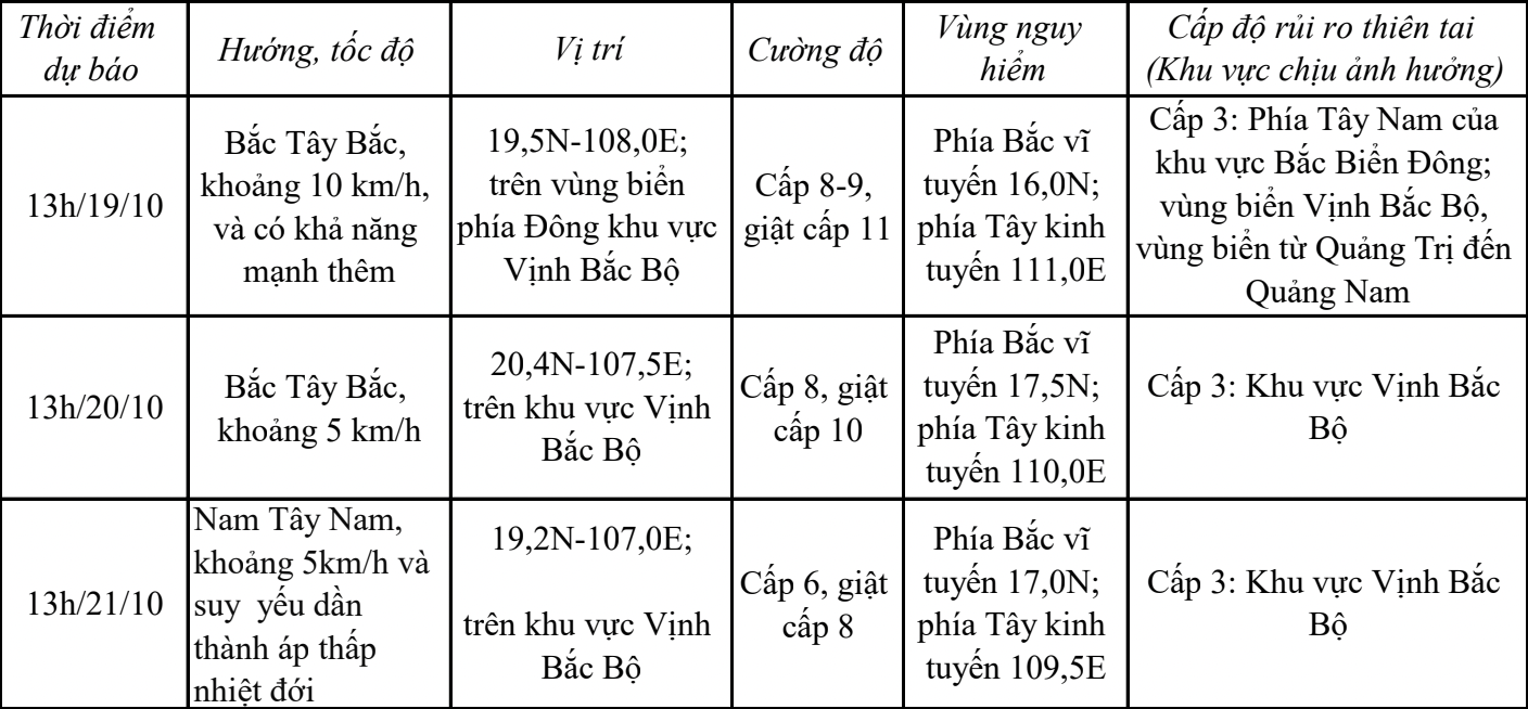
Over the next 72 to 96 hours, the tropical depression will continue to move slowly southward and further weaken.

Forecasts indicate strong winds of force 6-7 in the sea area from Quang Tri to Quang Nam, with winds near the storm's center reaching force 8-9, gusting to force 11, and very rough seas. In the Gulf of Tonkin (including Co To and Bach Long Vi), winds will gradually strengthen to force 6-7 from the night of October 18th, with winds near the storm's center reaching force 8-9, gusting to force 11. Very rough seas are expected.
In the sea area from Quang Tri to Quang Nam, waves are 2.0-4.0m high. In the Gulf of Tonkin (including Co To and Bach Long Vi), waves increased to 2.0-4.0m from early morning and throughout October 19th, then to 3.0-5.0m. All ships, anchorages, aquaculture areas, and sea dikes in this area are affected by strong winds and high waves.
From the afternoon of October 18th to October 19th, the North Central region will experience moderate rain, with some areas experiencing heavy to very heavy rain and thunderstorms. During thunderstorms, there is a possibility of tornadoes, waterspouts, lightning, and strong gusts of wind.