Nghe An plans Nghi Loc to become an important satellite connecting with Vinh urban area.
This is an important content in the Draft Project to adjust the Construction Planning of Nghi Loc district to 2030, with a vision to 2050, which has just been unanimously approved by the Provincial People's Committee.
Develop to become an important satellite connecting with Vinh city
The project to adjust the Nghi Loc district construction planning is planned for the entire natural area of Quan Hanh town and 28 communes with an area of 34,601 hectares.
.jpg)
Nghi Loc is located in a strongly urbanized area of the province when it is geographically adjacent to Vinh city and Cua Lo town. According to Decision No. 827 dated June 12, 2020 of the Prime Minister, Vinh urban space will expand to some areas of Nghi Loc district.
By the period 2030 - 2050, when these urban areas develop strongly, it will cause pressure on population, infrastructure, land... Nghi Loc district will be the affected area and will have the role of reducing the pressure on the above two urban areas. Therefore, the urbanization process of Nghi Loc district is an inevitable trend.
According to the planning project, in the regional development vision, by 2030, Nghi Loc will develop into an important satellite connecting with Vinh urban area; with developed industry, handicrafts, and services, forming a high-tech agricultural area serving Vinh city, Cua Lo and industrial parks in the Southeast Economic Zone.
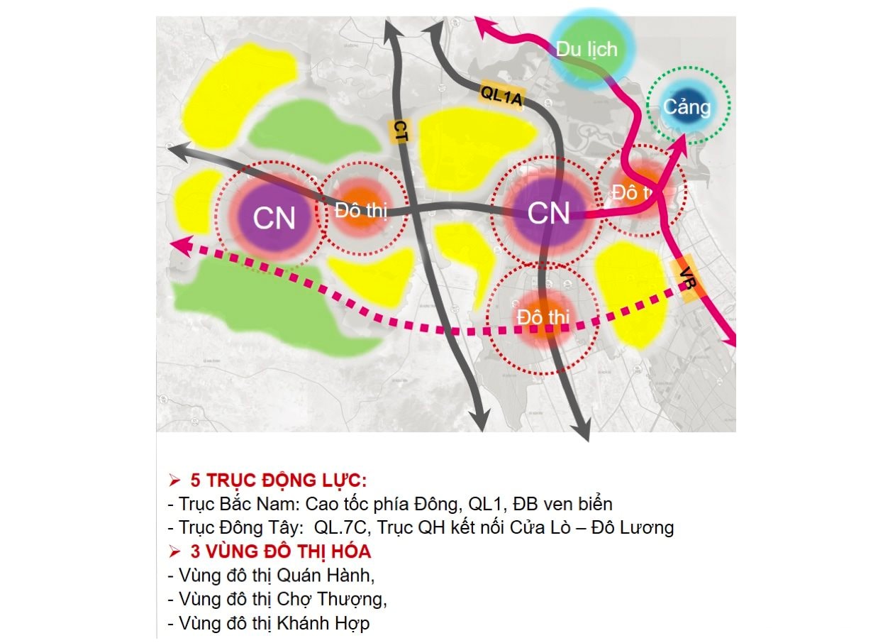
On that basis, Nghi Loc district will develop based on three main pillars, including: industry - urban; service - tourism; agriculture - rural areas.
.jpg)
The plan also aims to create three driving forces for economic development in Nghi Loc district, including: Forming tourism and service centers, social infrastructure works, and district-level technical infrastructure for the western region. Creating infrastructure connectivity and balanced development throughout the district.
Forming high-tech forestry and agricultural zones combined with industrial clusters to create development momentum and attract labor for the Western region.
Environmentally controlled industrial - logistic - seaport development. Integrating infrastructure - economic development with the Southeast Economic Zone.
5 dynamic axes, 3 urbanization zones
According to the planning, Nghi Loc district is identified with 5 development driving axes: North-South axis includes: Eastern Expressway, National Highway 1, coastal road. East-West axis includes: National Highway 7C, planning axis connecting Cua Lo - Do Luong. In addition, 3 urbanized areas are identified: Quan Hanh urban area, Cho Thuong urban area, Khanh Hop urban area.
In the district spatial development orientation, Nghi Loc is divided into 2 development zones. Zone 1 (Northwest zone) has an area of 263.09 km2, belongs to Nghe An Economic Zone, including 18 communes: Nghi Van, Nghi Lam, Nghi Kieu, Nghi My, Nghi Phuong, Nghi Cong Bac, Nghi Cong Nam, Nghi Hoa, Nghi Dien, Nghi Dong, Nghi Thuan, Nghi Hung, Nghi Quang, Nghi Thiet, Nghi Tien, Nghi Yen, Nghi Xa, Nghi Long.
This is a comprehensive zoning, closely linked to the development orientation of functional areas in the Southeast economic zone, industrial development, seaports - logistics, services and tourism; agricultural and forestry product processing industry, construction materials.
The Northwest region will be formed with main functional areas including: Development of resort tourism, high-class entertainment in coastal communes; Eco-tourism combining agriculture, forestry and rural areas in the West; Development of seaport system; Development of industry - logistics in industrial parks and port logistics areas.
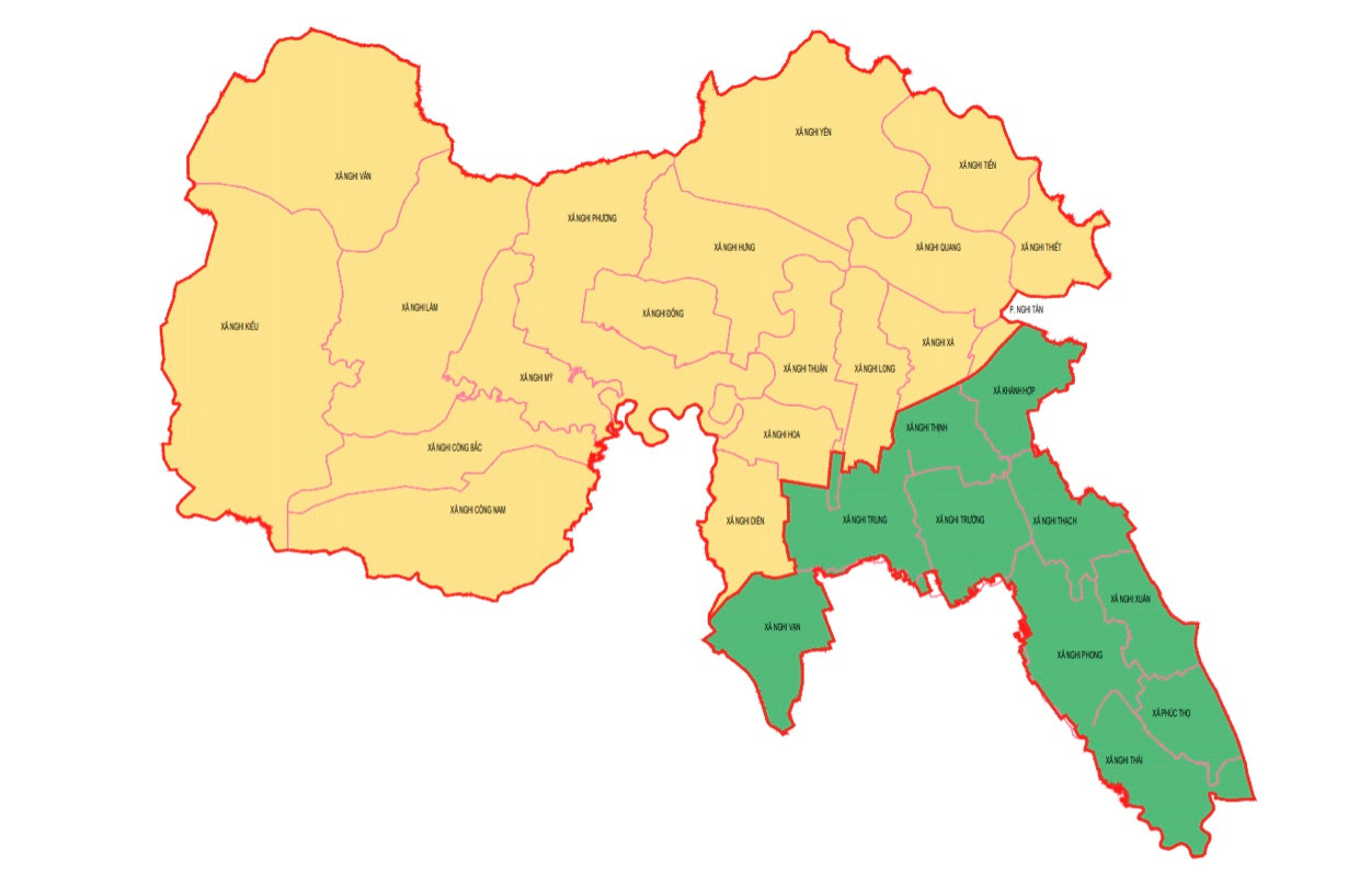
Forming large commercial and service centers in urban areas and tourist areas; Conserving and developing forests, forming industrial tree areas combined with building high-tech forestry zones in the North Central region. Developing livestock farms, creating sustainable ecological zones for the development of the district; developing synchronous social and technical infrastructure systems.
Zone 2 (Southern region), has an area of 82.92km2, including Quan Hanh town and 10 communes: Nghi Van, Nghi Trung, Nghi Thinh, Nghi Truong, Nghi Thach, Nghi Phong, Nghi Xuan, Nghi Thai, Phuc Tho, Khanh Hop.
This is a sub-zone in the Vinh city planning area with the role of administrative - political center, comprehensive economy, ecological buffer zone, development reserve area of the Vinh - Cua Lo - Quan Hanh urban system.
The Southern region will develop a system of urban ecological garden houses; Form large regional trade and service points in urban development areas; Form high-tech agricultural zones in Nghi Van and Nghi Truong communes.
In the urban development space orientation, by 2030, with a vision to 2050, in addition to Quan Hanh town, Cho Thuong town (Nghi My), Khanh Hop urban area, there will be planning to build urban development areas of Nghi Yen, Nghi Tien, and Nam Cam industrial service urban area according to the planning orientation of the Southeast Economic Zone.
In which, Quan Hanh town is built with the functions of administrative, economic, cultural, scientific and technical center of the district, is a satellite city, the northern growth pole of Vinh city.
Thuong Market Urban Area (Nghi My) is built as a cultural, social, commercial and economic center of the western region of Nghi Loc district. Khanh Hop Urban Area is the economic, cultural and new urban center of the eastern region of Nghi Loc district.