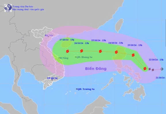
Storm news near the East Sea (storm TRAMI)
Early on October 22, a tropical depression in the sea east of the Philippines strengthened into a storm and was given the international name TRAMI.
1. Storm status:
Recall13 hour,The center of the storm is located at about 13.5 degrees North latitude; 126.5 degrees East longitude, in the sea east of the central Philippines. The strongest wind near the center of the storm is level 8 (62-74km/h), gusting to level 10. Moving northwest at a speed of 15-20km/h.
2. Storm forecast (in the next 24 to 72 hours):
| Expected timenewspaper | Direction, speed | Location | Intensity | Danger zonedangerous | Disaster Risk Level (Affected Area) |
| 13:00/23/10 | Northwest, about 15km/h, | 16.7N-124.0E; in the sea east of Lu Dong island (Philippines) | Level 9, level 11 | Latitude 14.0N - 19.0N; East longitude Route 122.0E | |
| 13:00/24/10 | West Northwest, 15-20km/h | 17.4N-120.4E; on the west coast of Luzon Island | Level 10, level 12 | Latitude 15.0N- 19.0N; East longitude Route 118.0E | Level 3: East of the North East Sea area |
| 13:00/25/10 | West, about 15km/h, entering the East Sea | 17.6N-117.0E; in the eastern sea of the North East Sea, 550km south of Hoang Sa archipelago East Northeast | Level 11, level 14 | Latitude 15.0N- 20.0N; East longitude Route 115.0E | Level 3: East of the North East Sea area |
3.Warning of old developmentsa Storm (in 72arrive120 next time):

4. Forecast of storm impact:
The East Sea area of the North East Sea has strong winds of level 6-7. From the morning of October 24, it will increase to level 8-9, near the storm center it will be level 10-11, gusting to level 14, waves 4.0-6.0m high, near the center 6.0-8.0m; rough seas.
Vessels operating in the above mentioned dangerous areas are susceptible to the impact of storms, whirlwinds, strong winds and large waves.
