Storm No. 6 Tra Mi enters the East Sea today, October 24
According to the meteorological agency's forecast, today, October 24, storm number 6 Trami entered the East Sea and continuously increased in intensity.
The National Center for Hydro-Meteorological Forecasting announced that at 7:00 p.m. on October 23, storm Trami (also known as Tra Mi) had formed in the sea east of Luzon Island, Philippines. The strongest wind near the storm's center reached level 9-10 (equivalent to 75-102 km/h) and there could be gusts of level 12. The storm moved west-northwest at a speed of about 15-20 km/h.
It is forecasted that by around 7pm on October 24, the storm will enter the East Sea and become the sixth storm of 2024. The storm will continue to move in a West-Northwest direction, then likely change direction to West-Southwest, at a speed of about 15 km/h. The center of the storm will be in the northeastern part of the East Sea, with the strongest winds near the center of the storm reaching level 9 and gusts of wind up to level 11.
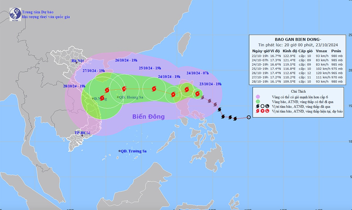
At around 7pm on October 25, storm No. 6 will appear in the northeastern part of the East Sea, 580km east of the Hoang Sa archipelago. The storm will move west-northwest at a speed of about 10-15km/h, with the strongest winds near the storm's center reaching level 10 and gusting to level 12.
By 7pm on October 26, the storm will be in the sea northeast of the Hoang Sa archipelago, moving west at a speed of 15-20 km/h. The strongest winds near the storm's center will increase, reaching level 11-12 and may gust to level 15. Thus, the storm will continue to strengthen after entering the East Sea.
During the next 72 to 120 hours, the storm will mainly move west at a speed of 10-15 km/h. After that, the storm may change direction to the South-Southwest and move more slowly.
The storm will cause strong winds of level 6-7 in the northeastern part of the East Sea. Near the storm's center, winds can reach level 8-9 (62-88 km/h) and gusts of level 11. Waves can be 3-5 m high, and near the storm's center they can reach 5-7 m, causing very rough seas.
In response to the complicated developments of storm Trami, on the afternoon of October 23, the Standing Office of the Steering Committee for Natural Disaster Prevention and Search and Rescue of Quang Ngai province issued a telegram requesting units and localities to inform captains operating at sea about the storm situation. Ships and boats must proactively take precautions and not move into dangerous areas.
In particular, ships and boats in the northern part of the East Sea and the Hoang Sa archipelago need to be cautious and quickly seek shelter. Units and localities need to count ships operating at sea, strictly manage the ships' departure to sea, maintain communication to promptly handle bad situations, and be ready with rescue forces to respond when necessary.