

LATEST NEWS ON TYPHOON NO. 5 (at 2 PM on August 25th)
At 13:00 on August 25th, the center of the storm was located at approximately 18.5 degrees North latitude and 106.3 degrees East longitude, in the coastal waters of the Nghe An-Ha Tinh region.
Due to the influence of Typhoon No. 5, the following weather stations recorded strong winds: Bach Long Vi (Hai Phong) - level 7, gusting to level 9; Co To (Quang Ninh) - level 7, gusting to level 10; Bai Chay (Quang Ninh) - level 6, gusting to level 8; Van Ly (Ninh Binh) - level 8, gusting to level 9; Dien Chau (Nghe An) - level 7, gusting to level 9; Quynh Luu (Nghe An) - level 7, gusting to level 12; Hon Ngu (Nghe An) - level 8, gusting to level 11; Hoanh Son (Ha Tinh) - level 7, gusting to level 9; Ky Anh (Ha Tinh) - level 7, gusting to level 11; Cam Nhuong (Ha Tinh) - gusting to level 8; Con Co (Quang Tri) - level 6, gusting to level 8; ...
Storm surges reached 0.91m in Sam Son (Thanh Hoa), 1.45m in Hon Ngu (Nghe An), and 0.51m in Vung Ang (Ha Tinh). In the Northern Delta provinces, from Thanh Hoa to Quang Tri, there was moderate to heavy rain, with some areas receiving over 300mm of rain.
At 13:00 on August 25thThe storm's center is located at approximately 18.5 degrees North latitude and 106.3 degrees East longitude, over the coastal waters of Nghe An and Ha Tinh provinces. The strongest winds near the storm's center are at level 13 (134-149 km/h), with gusts up to level 16; it is moving in a west-northwest direction at a speed of 15-20 km/h.
Storm forecast:
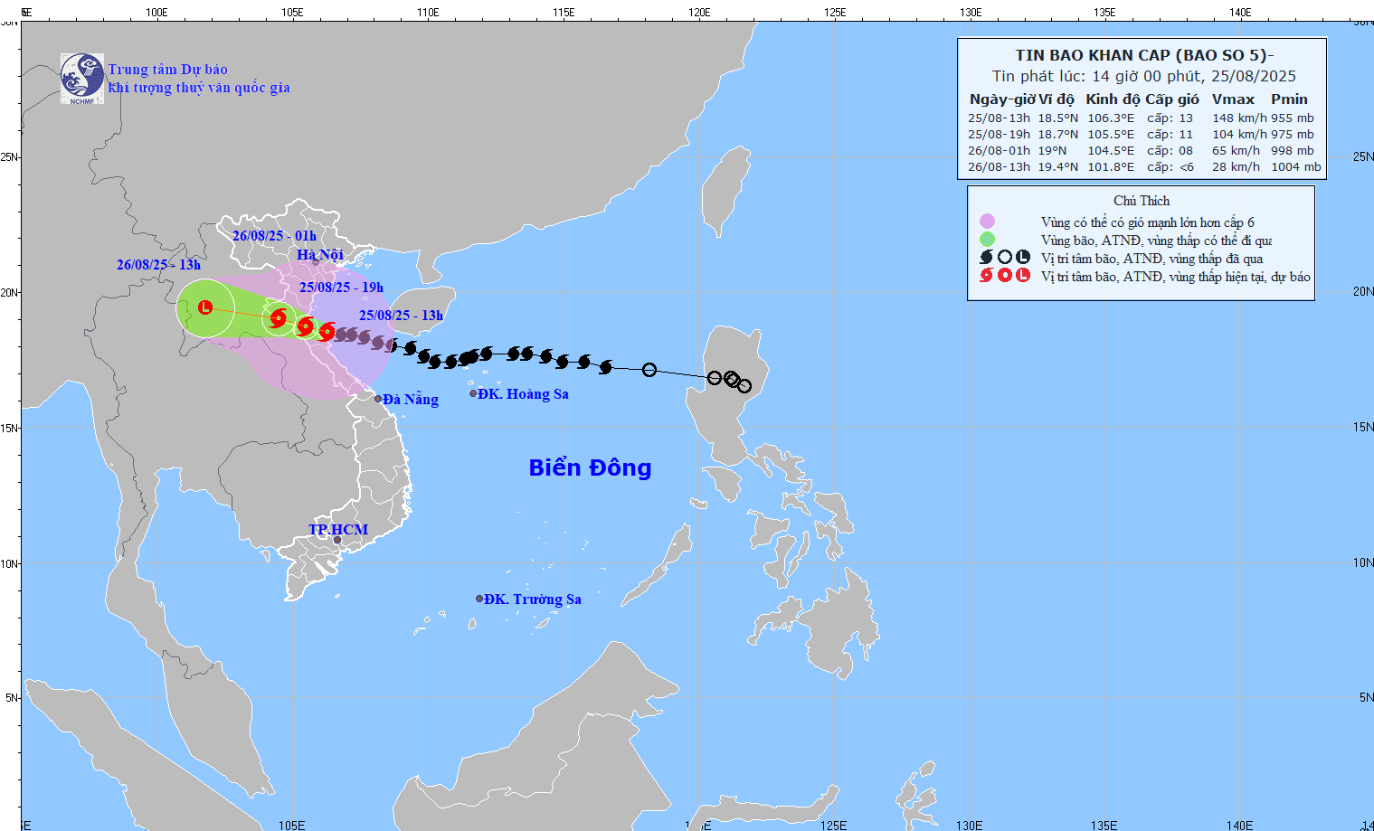
Forecast of the storm's impact:
The sea area from Thanh Hoa to Quang Tri (including Hon Ngu Island and Con Co Special Economic Zone) will experience strong winds of force 8-11, reaching force 12-13 near the storm's center, with gusts up to force 16; sea waves will be 5.0-7.0m high, reaching 8.0-10.0m near the storm's center; the sea will be extremely rough.
In the northern part of the Gulf of Tonkin (including the special zones of Cat Hai, Co To, and Van Don), winds will be strong at force 6-7, gusting to force 9; in the southern part of the northern Gulf of Tonkin (including the Bach Long Vi special zone), winds will be strong at force 7-8, gusting to force 10; sea waves will be 3.0-5.0m high; the sea will be rough.
Rising water levels:Along the coast and islands from Hai Phong to Nghe An, sea levels continue to rise due to high tides and storm surges. Storm surges are expected to reach 0.5-1.8m, with Thanh Hoa and Nghe An experiencing surges of 1.0-1.8m. Water levels at weather stations in Hon Dau (Hai Phong) are 3.4-3.9m, Ba Lat (Ninh Binh) 1.7-2.2m, Sam Son (Thanh Hoa) 3.7-4.2m, and Hon Ngu (Nghe An) 3.8-4.2m. There is a high risk of flooding along dikes, coastal roads, and river mouths, especially along the coast of Nghe An and Thanh Hoa, on the afternoon and evening of August 25th.
Warning:Weather conditions at sea and in coastal areas during storms are extremely dangerous and unsafe for any vehicles or structures operating in hazardous zones, such as: tourist boats, passenger ships, cargo ships, cages, rafts, aquaculture farms, dikes, embankments, and coastal roads. Vehicles are highly likely to capsize or be destroyed; flooding is possible due to strong winds, large waves, and rising sea levels.
On land: the northern Thanh Hoa area will experience strong winds of force 8-9, gusting to force 10-11;The area between southern Thanh Hoa and northern Ha Tinh will experience strong winds of force 10-11, with winds near the storm's center reaching force 12-13, and gusts of force 14-15.In southern Ha Tinh and Quang Tri provinces, and coastal areas of provinces from Quang Ninh to Ninh Binh, there will be strong winds of level 6-8, gusting to level 9-10.
Heavy rain:
- From the afternoon of August 25th to the end of August 26th, heavy rain is expected over a wide area in the midland and lowland regions of Northern Vietnam, Lao Cai, Son La, and from Thanh Hoa to Quang Tri, with rainfall amounts generally ranging from 70-150mm, and locally exceeding 250mm; particularly in the area from Thanh Hoa to northern Quang Tri, there will be heavy to very heavy rain with rainfall amounts generally ranging from 150-350mm, and locally exceeding 500mm. A warning is issued regarding the risk of heavy rainfall (>200mm/3h).
- From the afternoon of August 25-26, the Hanoi area will experience moderate to heavy rain and thunderstorms; Da Nang City will have occasional showers; and Ho Chi Minh City will have rain, showers, and thunderstorms (thunderstorms concentrated in the afternoon and evening). During thunderstorms, be aware of the risk of tornadoes and strong gusts of wind.
- From the afternoon of August 25th to 27th, the Upper and Central Laos regions experienced heavy rainfall with amounts generally ranging from 100-250mm, and in some localized areas of Central Laos, exceeding 500mm.