Urgent storm news: Super storm No. 9 with level 17 strength is heading towards the Gulf of Tonkin, Nghe An is about to have very heavy rain
According to the urgent storm bulletin issued at 5am this morning (September 23) by the Nghe An Province Hydrometeorological Station, super storm No. 9 (Ragasa storm) is active in the East Sea with the strongest wind reaching level 17, gusting above level 17. The storm is forecast to move quickly, enter the mainland of southern China, then weaken and directly affect the northern region of Vietnam. Nghe An province is warned to have a period of heavy to very heavy rain from the night of September 24.
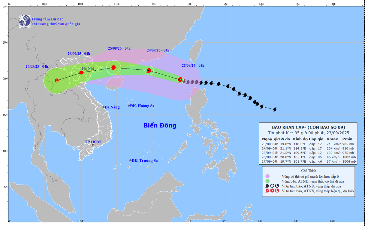
Current location and intensity of the super typhoon
At 4:00 a.m. on September 23, the center of super typhoon No. 9 was at about 19.8 degrees North latitude; 118.8 degrees East longitude, in the northeastern sea of the North East Sea. The strongest wind near the center of the super typhoon was level 17 (202-221 km/h), gusting above level 17. The storm was moving in a West Northwest direction at a speed of about 20 km/h.
Forecast of storm path and intensity
- Until 4:00 on September 24:The storm is moving in the West Northwest direction at a speed of 20-25km/h, located at about 21.1 degrees North Latitude - 114.5 degrees East Longitude, in the northern sea area of the North East Sea. Wind force remains at level 16-17, gusting above level 17.
- Until 4:00 on September 25:The storm continues to move west-northwest at a speed of 20-25km/h and begins to weaken. The center of the storm is located at approximately 21.5 degrees North latitude - 109.6 degrees East longitude, on the mainland south of Guangzhou province (China). Wind force is level 12, gusting to level 15.
- As of 4:00 a.m. on September 26:The storm changed direction to move West Southwest, speed 20-25km/h and weakened into a tropical depression. The center of the tropical depression is located at about 20.8 degrees North latitude - 105.1 degrees East longitude, in the Northern region. Strong winds of level 6, gusts of level 8.
From the next 72 to 96 hours, the tropical depression will move in the West Southwest direction, about 20km per hour and continue to weaken into a low pressure area.
Forecasting the impact of super typhoons
Strong winds and big waves at sea
- North East Sea area:The northern sea has strong winds of level 8-9, then increasing to level 10-14, the area near the center of the super storm has strong winds of level 15-17, gusting above level 17. Waves are over 10.0m high, the sea is very rough.
- Gulf of Tonkin area:From September 24, the wind will gradually increase to level 6-7, gusting to level 9. From the evening and night of September 24, the wind will gradually increase to level 8-9, near the storm center it will increase to level 10-12, gusting to level 14. Waves will be 4.0-6.0m high, with rough seas.
Strong winds on land
- From early morning on September 25, coastal areas from Quang Ninh to Thanh Hoa will have winds gradually increasing to level 6-7, then increasing to level 8, areas near the storm center will have strong winds of level 9-10, gusting to level 12.
- The inland area of the Northeast has strong winds of level 6-7, gusting to level 8-9.
Heavy rain in Nghe An
- From the night of September 24 to September 26, in Nghe An there will be heavy to very heavy rain with common rainfall from 100-200mm, locally over 250mm.
Warning of associated risks
Beware of heavy rain causing urban flooding.
Heavy rain is likely to cause flooding in low-lying areas; flash floods in small rivers and streams and landslides on steep slopes.
Due to the influence of the wide storm circulation, it is necessary to guard against the risk of thunderstorms, tornadoes and strong gusts of wind both before and during the storm's landfall.