Storm No. 13 Kalmaegi is forecast to cause heavy rain in the Central provinces.
The impact of storm No. 13 Kalmaegi's circulation is very widespread, causing heavy rain, thunderstorms, whirlwinds and strong gusts of wind in the Central provinces both before and during the storm's landfall in Vietnam.
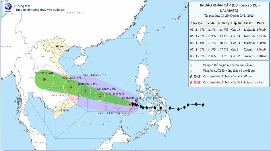
According to the National Center for Hydro-Meteorological Forecasting, Storm Kalmaegi is moving rapidly into the East Sea and will directly affect the Central Highlands region from November 6.
Under the impact of wide circulation, the storm will cause especially heavy rain, concentrated mainly in the provinces from Da Nang to Dak Lak.
Total rainfall during this period is generally 200-400mm, in many places it may exceed 600mm/period. With heavy rainfall in a short period of time, mountainous localities of Quang Nam, Kon Tum, Gia Lai and Dak Lak are warned of a very high risk of flash floods, landslides and localized flooding.
Authorities recommend that people in low-lying areas and along rivers and streams proactively move to safety before Storm Kalmaegi moves further inland.
Not only the Central Central region, the circulation of Storm Kalmaegi also covers the provinces from South Quang Tri to Hue, Khanh Hoa and Lam Dong. Here, the rainfall is forecast to reach 150 - 300mm/period, in some places over 450mm.
Continuous heavy rain on November 6-7 caused river systems to rise, and many coastal and low-lying residential areas could be deeply flooded.
In Thua Thien Hue and Khanh Hoa, water levels on the Huong, Cai and Dinh rivers are forecast to exceed alert level II. Local authorities have prepared plans to evacuate people from areas at risk of flooding and strictly control traffic through Hai Van Pass and National Highway 1A as Typhoon Kalmaegi approaches the shore.
After Typhoon Kalmaegi makes landfall, the rain circulation will expand to the North Central provinces on November 7-8. The area from Northern Quang Tri to Thanh Hoa is forecast to have moderate to heavy rain with common rainfall of 50-150mm, locally over 200mm.
Heavy rains on saturated ground can easily lead to the risk of flooding in the mountainous districts of Quang Binh and Nghe An. Hydropower reservoirs such as Ke Go, Rao Quan and Ho Ho have been asked to proactively release water to reduce pressure when Storm Kalmaegi causes prolonged rain.
Since the evening of November 6, coastal areas from Hue to Dak Lak have been hit by a double impact of heavy rain and rising water caused by Storm Kalmaegi. Sea levels have risen by 0.3-0.6m combined with large waves of 6-8m, causing a sharp increase in the risk of deep flooding and coastal erosion.
Low-lying coastal areas of Quang Nam, Binh Dinh and Khanh Hoa could be isolated if the rain continues for many hours.
The meteorological agency recommended that localities mobilize local forces to assist people in evacuating, while protecting reservoirs, irrigation works, dikes and pumping stations to minimize damage caused by the circulation of Typhoon Kalmaegi.
Meteorological experts warn that the rain caused by Typhoon Kalmaegi is not only large in volume but also concentrated in a short period of time, with some places experiencing over 200mm of rain in just 3 hours. This extreme rainfall phenomenon can be accompanied by thunderstorms, tornadoes and strong gusts of wind.
In particular, the mountainous provinces of Quang Nam, Kon Tum, and Lam Dong, where the terrain is steep and the soil is weak, are at very high risk of landslides. People are advised not to cross streams, creeks, hillside areas, and areas experiencing heavy rain when Typhoon Kalmaegi makes landfall.
Typhoon Kalmaegi is forecast to be one of the most severe storms in 2025. With a wide circulation range and strong intensity, the Central Highlands provinces need to be ready to respond to the highest level, especially to prevent flash floods, landslides and widespread flooding.