Adjusting the planning on both sides of the Vinh - Cua Lo boulevard: Expanding the strategic urban space.
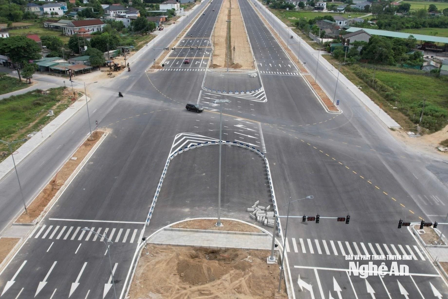
The 11.2 km long Vinh - Cua Lo Boulevard is not only a transportation route connecting the center of the old Vinh City with the coastal town of Cua Lo, but also a strategic driving force in the new development space of Nghe An.
After nearly 10 years of implementing the old plan for both sides of the boulevard, and with many changes brought about by the times, adjusting the zoning plan for both sides of the boulevard has become an essential requirement.
rangethe importance of a large-scale plan
The Vinh – Cua Lo Boulevard is a strategic connecting axis between the former Vinh city and Cua Lo, playing a crucial role in expanding urban space towards the sea. This route not only shortens geographical distances but also creates a corridor for economic, tourism, and service development throughout Nghe An province. Therefore, the planning on both sides of the boulevard signifies a modern, integrated urban structure with a long-term vision. This also serves as an important foundation for attracting investment and forming a chain of high-quality urban, service, and resort areas in the future.
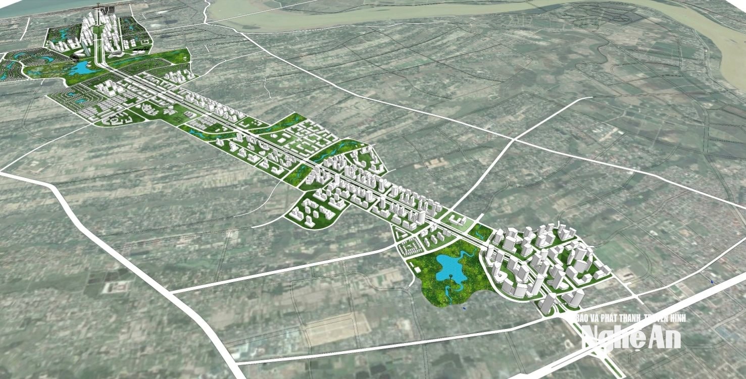
Since August 2019, the People's Committee of Nghe An province has approved the zoning plan for the Vinh - Cua Lo Boulevard and the areas on both sides of the route, at a scale of 1/2,000. This is considered an important step in realizing the strategy of expanding Vinh's urban space towards the sea, while also creating a foundation for linked development between the central urban area and Cua Lo.
According to this plan, the 11.2 km long boulevard is divided into 5 functional zones with a total area of approximately 1,752 hectares. Each zone plays a distinct role, creating a harmonious development whole: from the administrative center, research and development area, residential area, sports area to the high-end coastal resort and tourism center. The plan also sets out a vision for the formation of a modern urban axis with a 220-250 m wide built-up area on each side, integrating a public transportation system, including the idea of an urban railway line running along the boulevard.
At the time of its promulgation, this plan demonstrated pioneering thinking, shaping a new development space for Vinh city and its surrounding areas.
However, after many years of implementation, the development context has changed significantly. Along with this, the rearrangement and adjustment of administrative boundaries, as well as changes in urban development needs, have revealed some limitations in many aspects of the old plan.
Meeting development needs
At a recent meeting of the Nghe An Provincial People's Committee on adjusting the zoning plan for the boulevard, the consulting agency summarized the shortcomings of the old plan. First and foremost is the issue of population size. The old plan projected a population of just over 46,000 people – a figure considered low compared to the potential of a dynamic urban axis. With this scale, it would be difficult to develop high-quality service ecosystems or attract large investors.
Mr. Doan Van Dai, Deputy Director of the Department of Construction, stated: The adjustment of the planning aims to develop the Vinh - Cua Lo boulevard into a modern economic and social center, connecting the old urban core with the coastal area. The Provincial People's Committee has assigned the Department of Construction the task of adjusting the zoning plan for the Vinh - Cua Lo boulevard and the areas on both sides of the Vinh - Cua Lo boulevard. Accordingly, it involves reviewing and updating the current situation; comprehensively evaluating ongoing projects to address existing shortcomings. The goal is to ensure consistency between the detailed plan and the Nghe An Provincial Planning for the period 2021-2030, with a vision to 2050, especially in line with the administrative unit merger roadmap.
In addition, the land use plan will be adjusted, land allocation for functional areas will be rebalanced, prioritizing social infrastructure and public works after the merger; improving the efficiency of land use according to the principle of harmonizing economic development and landscape preservation. Population density and key areas such as the new administrative center, commercial and tourism zones will be clearly defined. A significant population increase is projected, requiring infrastructure development to be proactive.
Architectural and landscape spatial organization: Using the Vinh - Cua Lo Boulevard as the backbone for the development of modern, ecological urban areas, ensuring seamless connectivity between existing residential areas and new urban areas. Creating large squares, green spaces, water features, and especially incorporating underground space planning to conserve land resources and reduce infrastructure burden. Re-determining the alignment and road widths of urban and ward-level roads to optimize land use, minimize land compensation and resettlement costs, and increase feasibility.
The new master plan has taken into account the airspace clearance of Vinh International Airport more carefully, ensuring a balance between urban development and aviation safety. Building heights are flexibly adjusted, ranging from 15 to 40 stories, gradually increasing towards the sea, creating a skyline highlight while ensuring compliance with regulations.
Regarding public transportation systems, the metro line concept in the old plan, while modern, was not truly feasible in terms of investment resources.
In particular, a significant milestone in the latest adjustment of the Vinh - Cua Lo Boulevard master plan is the issuance of Decision No. 1500/QD-UBND dated April 16 by the People's Committee of Nghe An province, approving the partial adjustment of the Vinh - Cua Lo Boulevard zoning plan and the area on both sides of the Vinh - Cua Lo Boulevard (a part of the master plan).
According to Decision No. 1500/QD-UBND, the local adjustments focus on several key areas along the route to update land use indicators, architectural spatial organization, and technical infrastructure systems to suit the actual situation. The adjustments aim to more effectively utilize the land on both sides of the boulevard, increase investment attraction, and change some traffic routes, ensuring consistency with higher-level plans and ongoing infrastructure projects. A noteworthy point is that the local adjustments do not alter the overall nature of the entire boulevard, but rather aim to improve and optimize the functions of the areas.
Mr. Nguyen Duc Tho, Chairman of the Dong Loc Commune People's Committee, said: Regarding the local adjustment of the Vinh - Cua Lo Boulevard zoning plan, the higher authorities consulted with the commune and the local community. The commune will continue to disseminate information to ensure that the political system and the people understand and manage land in accordance with the approved plan.
The issuance of Decision No. 1500/QD-UBND is of particular importance, serving as a concrete legal basis for the planning adjustment process, shifting from orientation to action. Secondly, it creates momentum for the remaining sub-areas to continue being reviewed, opinions gathered, and dossiers finalized for approval of adjustments in the near future.
Expanding urban areas towards the sea.
The Vinh - Cua Lo Boulevard does not exist in isolation but is part of Nghe An's increasingly完善 infrastructure system. The North-South expressway, which passes through the area, has been put into operation, along with the completed national coastal road, creating a strong inter-regional connectivity network.
.jpg)
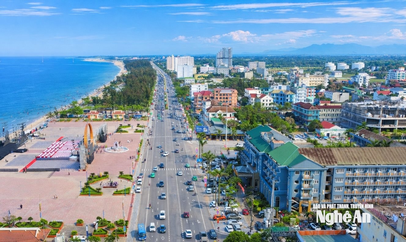
In this context, the boulevard acts as a "distribution axis," receiving and regulating traffic flow from all directions, especially the influx of tourists and investors from the North into Cua Lo. The intersection of the boulevard with strategic transportation routes opens up opportunities for the formation of large-scale service, logistics, and tourism centers.
Furthermore, the wave of FDI investment in Nghe An is accelerating, with the presence of large industrial parks such as VSIP and WHA. These projects not only bring economic value but also create a great demand for housing, services, and high-quality living spaces for experts, engineers, and workers.

When the zones on both sides are adjusted synchronously, the boulevard will not only be a transportation route, but will become an economic corridor, a model living space, and a new symbol of the province's development. With the right vision, decisive leadership, and the consensus of the people, the Vinh - Cua Lo boulevard will truly become the "backbone" driving Nghe An's breakthrough in the coming period.
Adjusting and implementing the planning on both sides of the Vinh - Cua Lo boulevard also presents numerous challenges. There is a risk of uncontrolled development, especially the situation of land subdivision and speculation, if there is no strict management mechanism. This requires the coordinated involvement of all levels and sectors in controlling the market, selecting capable investors, and prioritizing large-scale projects with a ripple effect...