
Update on the tropical depression in the East Sea on the afternoon of August 19th.
According to forecasts, the strongest winds near the center of the tropical depression will be at level 6 (39-49 km/h), with gusts up to level 8.
1. Hien trsir/ma'amngap thap nhiamnesiai:
HOhi 13 giuhAugust 19thThe center of the tropical depression is located at approximately 19.6 degrees North latitude and 112.2 degrees East longitude, in the northwestern part of the South China Sea, about 180km east of Hainan Island (China). The strongest winds near the center of the tropical depression are at level 6 (39-49km/h).giậtcap 8. Move in a west-northwest direction at a speed of 5-10 km/h.
2. Dselfnewspaperễn biunmarketablenap thap nhiamnesiai (within 24 hoursemperorn 48 hoursuhtOhi)
| Ladytimemdselfbao | Directionsng, tspeed | Vpoopintelligence | Intensity | Hazardous areaem | Ctemperaturerincubatei ro natural disaster (Area vselfmethodpoopuhernhopenng) |
| 13:00 on August 20th | West, approximately 5 km/h | 19.7N-111.0E; in the sea northeast of Hainan Island (China) | Potential for further enhancement. Level 6-7, bursts at level 9. | 18.5-21.0N; 109.5-113.0E | Level 3: the northwestern sea area of the North East Sea region. |
| 13:00 on August 21st | West-northwest, approximately 5 km/h | 20.1N-109.9E; over the northern part of Hainan Island (China) | Level 6-7, gusts up to level 9. | 18.5-21.5N; 109.0-112.0E | Level 3: the northwestern sea area of the North East Sea and the eastern sea area of the Gulf of Tonkin. |
3. Chernewspaperễn biunmarketablen app thap nhiamnesiai (tfrom 48 emperorsn 72 hoursuhtOhi):Over the next 48 to 72 hours, the tropical depression will move slowly in a west-northwest direction, traveling approximately 5 km per hour.
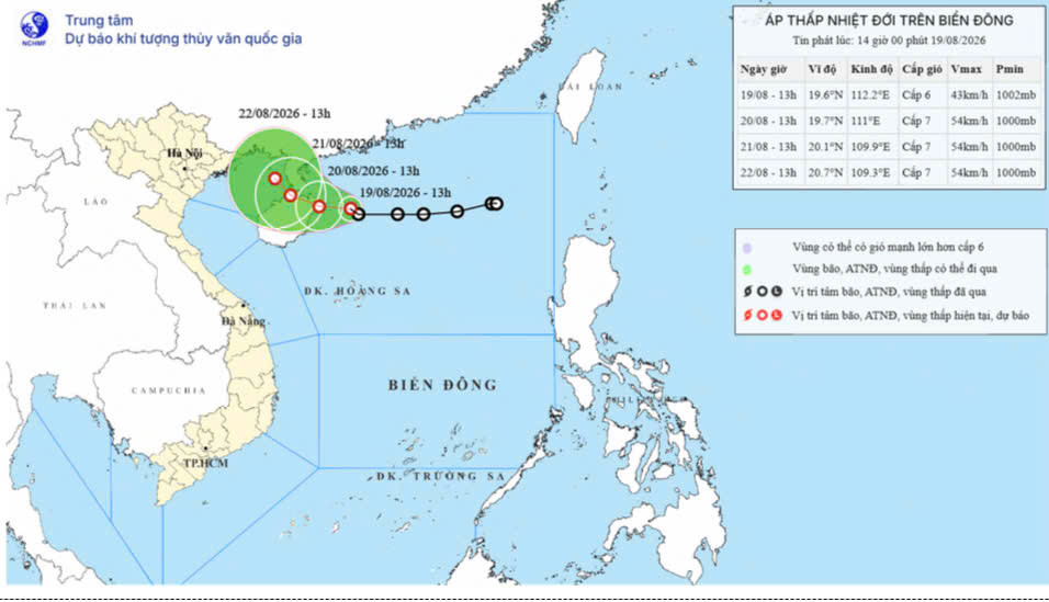
4. Dimpact forecastng cincubatea pressureap nhiamnesiai Gioomsir/ma'amnh, wave lOhn
On the ballen:
The northwestern part of the North East Sea region experiences strong winds of force 6-7, gusting to force 9; waves 2.0-3.5m high; and rough seas. Vessels operating in these dangerous areas are at risk of being affected by thunderstorms, tornadoes, strong winds, and high waves.
PV