


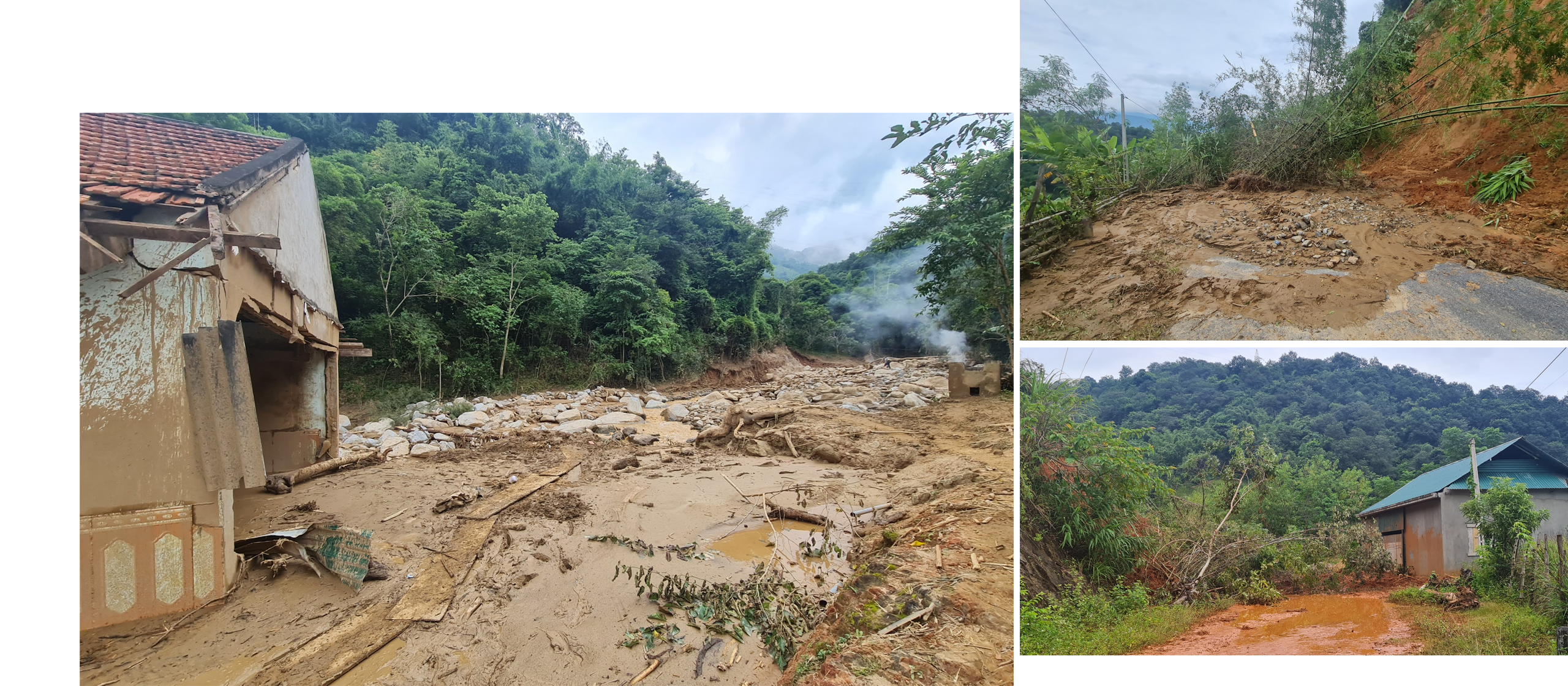
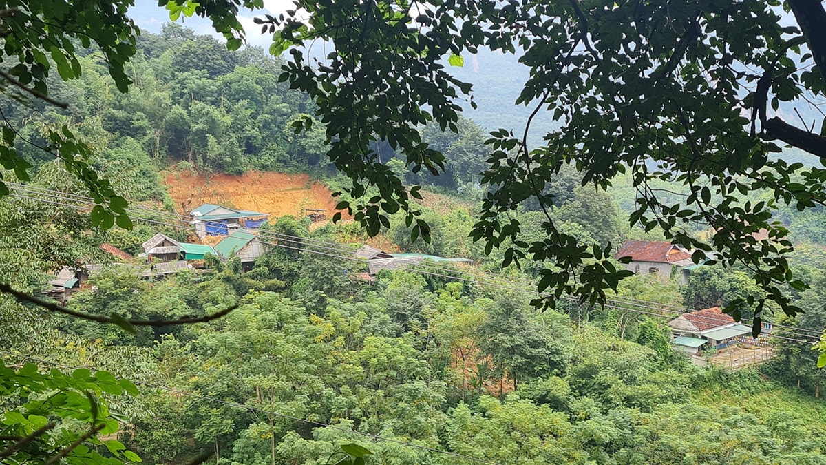
Hoa Son is the village that suffered the most damage from the flash flood that hit Ta Ca commune, Ky Son district on the night of October 1 and the morning of October 2. Hoa Son had 36 houses swept away, and more than 100 houses collapsed and were severely damaged.
Stopping by Mrs. Luong Thi Hong’s house (Hoa Son village), amidst the mess of rocks and soil, she was trying to grab a few handfuls of betel leaves covered in mud left after the flood. She said: “I am 72 years old, I have never experienced such a terrible flood. My son’s house completely collapsed. My stilt house in the back is higher and the first floor is submerged. When the flood came, if my son had not pulled me by the hand and run away, I would have been swept away by the rocks and soil…”.
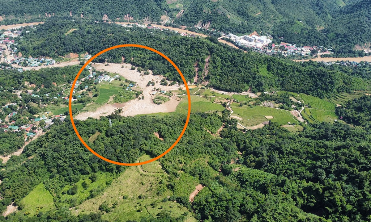

Coming to Son Ha village to visit the most famous and fertile terraced fields in the region, now there are scattered boulders weighing tens of tons along with mud, bushes, grass and rubbish... Mr. Vi Van Nhui's house was just built not long ago, now only a shaky wall remains between the intersection of the flowing water. Mr. Vi Van Xuan's house, then the area of the watchtower and fish pond of Mr. Vi Van Thoong, formerly the most beautiful place in the village with green terraced rice fields interspersed with a system of fish ponds, has now also been completely buried by giant boulders and sand. Ms. Mua Y Do's house is located in a position to "receive" the flash flood, so not only did she lose her house, but her 4-month-old daughter who could not yet say "mom" was also taken by the flood. The tears and sorrowful cries of the mother who lost her child, of those whose houses and doors were swept away, made the flood-hit area of Son Ha and Hoa Son covered in a scene of mourning.
Asking the people, where did the fierce flood originate? Mr. Mua Dua Tong (Son Ha village) said that the flood originated from the fields of Son Ha households, opposite the production area of Huoi Giang village, Tay Son commune. This area has many streams around the mountain area between Tay Son commune and Ta Ca commune running through to Son Ha, Hoa Son, Binh Son 1, Binh Son 2 villages with 2 streams Huoi Loong and Huoi Can. "This time the flood came along the small streams. The big stream Huoi Giang from Tay Son commune to Son Ha and Hoa Son is not as fierce as the floods in the other 2 small streams" - Mr. Tong said.


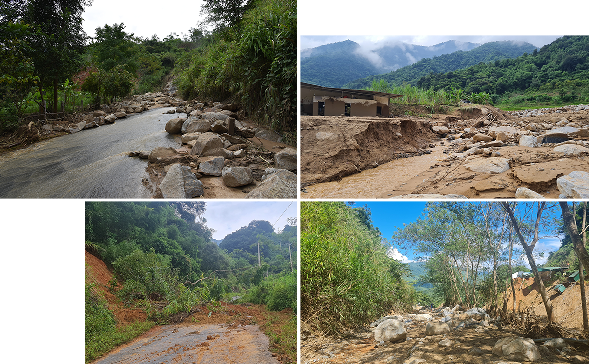
From the people's words, we reached the end of Son Ha village. Here, walking along the stream bed created after the flood swept up the mountain for about 500m, we met many groups of people from Tay Son commune. When we asked, they said that the flash flood in Ta Ca commune caused the Tay Son - Muong Xen road to collapse in many places, motorbikes could not go, and the villages in Tay Son were isolated for two days. Therefore, we had to cut the mountain, follow the stream to Muong Xen town to buy food. Also along this road, every few dozen meters there was a landslide. Rocks, bushes, vines... from above fell onto the road, blocking the path, leaving bare rocky slopes.
Also here, Ms. Lau Y Xo (Son Ha village) just returned from her family's farming area and said: "Our village has always had a difficult and scarce source of drinking water. We don't have enough water all year round, so we have to bring pipes down from the stream near Tay Son commune. I don't understand why there is so much water coming from the mountains this time...". Mr. Moong Van Hung - Secretary of the Binh Son 1 village Party Cell also affirmed: "The big stream from Huoi Giang village of Tay Son commune has no more water since March and April, so it is called Can stream. As for the small stream where the flood chose to make a path, water was even scarcer before, so we had to get water for daily use from a source high up near Tay Son. That is also the C5 production area of the people...".
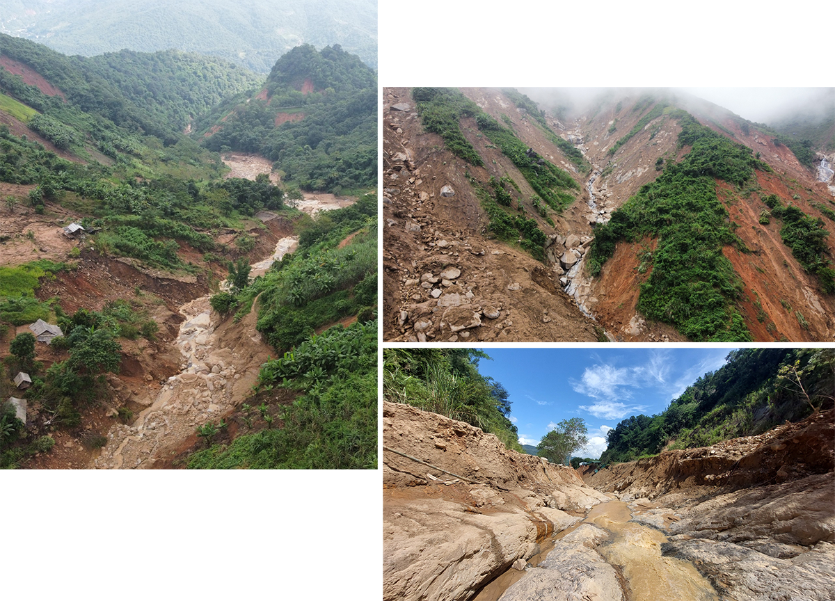
Continuing along the stream bed up the mountain to the location bordering Hoa Son village, we could not go further. Because this place formed a deep hole in the middle of the ravine. On one side of the hole, there were 2 houses on the Tay Son - Muong Xen road, half of which were lost. On the other side, a long stretch of asphalt road leading to the center of Son Ha village was also wiped out. The people's questions were answered. The formation of a deep lake in the middle of this ravine was due to long-term rain causing rocks and soil to slide down from the cliffs, collapsing and blocking, creating a dam to form a lake. And when it rained heavily, a "water bomb" was formed hanging over the heads of Son Ha and Hoa Son villages.
Finding a way to continue walking along the remaining asphalt road, cutting through a hill, we reached the point where the people of Hoa Son village said there was a spillway bridge that had been buried for many years. The scene was a large stream with a depth of tens of meters with large, round-shaped rocks scattered about, blocking the muddy water that continued to flow strongly. It was determined that this was the second "water bomb". Thus, the two streams on both sides of the hill above Son Ha and Hoa Son villages, due to prolonged rain, had formed two "water bombs". When the heavy rain poured down, the two "water bombs" were too much to bear, the natural "earthen dams" that had been soaked with water for many hours became soft, burst, creating a flash flood, pouring down to the rice fields south of Son Ha village, then together with water from Huoi Giang stream poured down to Hoa Son village, creating an unprecedentedly terrible devastation.
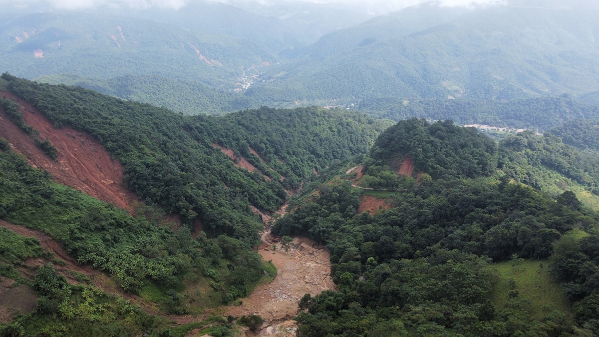
On the third day after the flood hit the villages in Ta Ca commune, Ky Son district also established a field survey team to identify the source of the flash flood. The team, led by Mr. Ly Ba Thai - Deputy Secretary of the District Party Committee, followed the streams to the upstream villages, including Canh, Binh Son 1, Binh Son 2. After the survey, Mr. Ly Ba Thai also commented: "The origin of the fierce flood originated from the people's farming areas, flowing down through small streams. This area is adjacent to the farming areas of Tay Son commune, which is also where people in Binh Son 1, Binh Son 2, Son Ha, Hoa Son villages produce and get water for daily use. The hills in this area, besides the people's farming areas, the remaining area mostly has a thin layer of trees, mainly small bushes, so they have almost no ability to retain water and prevent landslides."
“On the night of October 1, the authorities reported that Son Ha, Binh Son 1, Binh Son 2 and Canh villages were experiencing continuous heavy rain. This rain fell on the fields of Son Ha, Binh Son 1, Binh Son 2 and part of Tay Son commune’s fields. As a result, floodwaters formed and followed small red streams downstream. The rain caused landslides in the mountains, carrying away rocks, soil, and trees before being dumped into Son Ha and Hoa Son villages. On October 10, after more than a week of flooding, people in Son Ha and Hoa Son continued to have to evacuate because of the high threat of landslides,” said Mr. Ly Ba Thai.

From the current situation, one wonders why there is almost no natural protective forest left in the mountainous area here. According to Mr. Moong Van Thi (Binh Son 1 village), around 1990, the State mobilized households to move to lower streams for convenience, and people in Binh Son 1 and 2 villages moved to their current residence. His village in the past also lived on high mountains, and the Tay Son headwaters still have many forests...
Many households in Son Ha village said that they were formerly residents of Tay Son commune, then moved to Ta Ca commune to settle in a lower area, closer to the water source, more convenient for making a living. But even though they moved, they still kept their farming and farming locations in the mountains far upstream. For livelihood and many other reasons, the upstream forests that have the effect of retaining soil, retaining water, and preventing landslides and flash floods are gradually being cut down, to be replaced by production forests and slash-and-burn farms.
Ky Son is a locality with high mountainous terrain, large slopes, and limited land fund, so the arrangement of residents in areas along streams and roads is obvious. In other words, there is no other choice! But there is no protective forest, which means there is nothing to retain water, nothing to prevent flash floods and landslides. The inevitable consequence of the law of nature has occurred. Therefore, the urgent issue that needs to be done is to quickly re-evaluate the weak areas at the headwaters of Ky Son district, where there are residential clusters, to clear the flow; and consider regenerating protective forests.
Agreeing with this assessment, the representative of the Survey Team of Ky Son district affirmed that, in the immediate future, the district will conduct a survey to check the situation of landslides and threatened cracks on the mountain slopes, promptly warn and evacuate people to safe places. At the same time, it is also a step to prepare for the work of assessing, overcoming consequences and responding to natural disasters in the future. Accordingly, the sustainable and long-term solution is still to protect the upstream forests, creating a natural shield to protect people from unexpected natural disasters. At the same time, there must be a solution to not leave bare hills and mountains, while ensuring production and life for the people.
Along with the participation of the government and all levels of sectors, for the people, it is also necessary to equip them with knowledge and skills to cope with natural disasters such as storms and floods, and the significance of afforestation and forest protection in the upstream areas. Let them see that the skills to cope with natural disasters and the development and protection of forests are also to protect the lives of their families and the lives of the villagers.
Ky Son is not the only one with Tay Son and Ta Ca lacking upstream protection forests, while the storm and flood season continues to last. Therefore, along with overcoming natural disasters, it is necessary to implement preventive solutions to minimize damage!
