


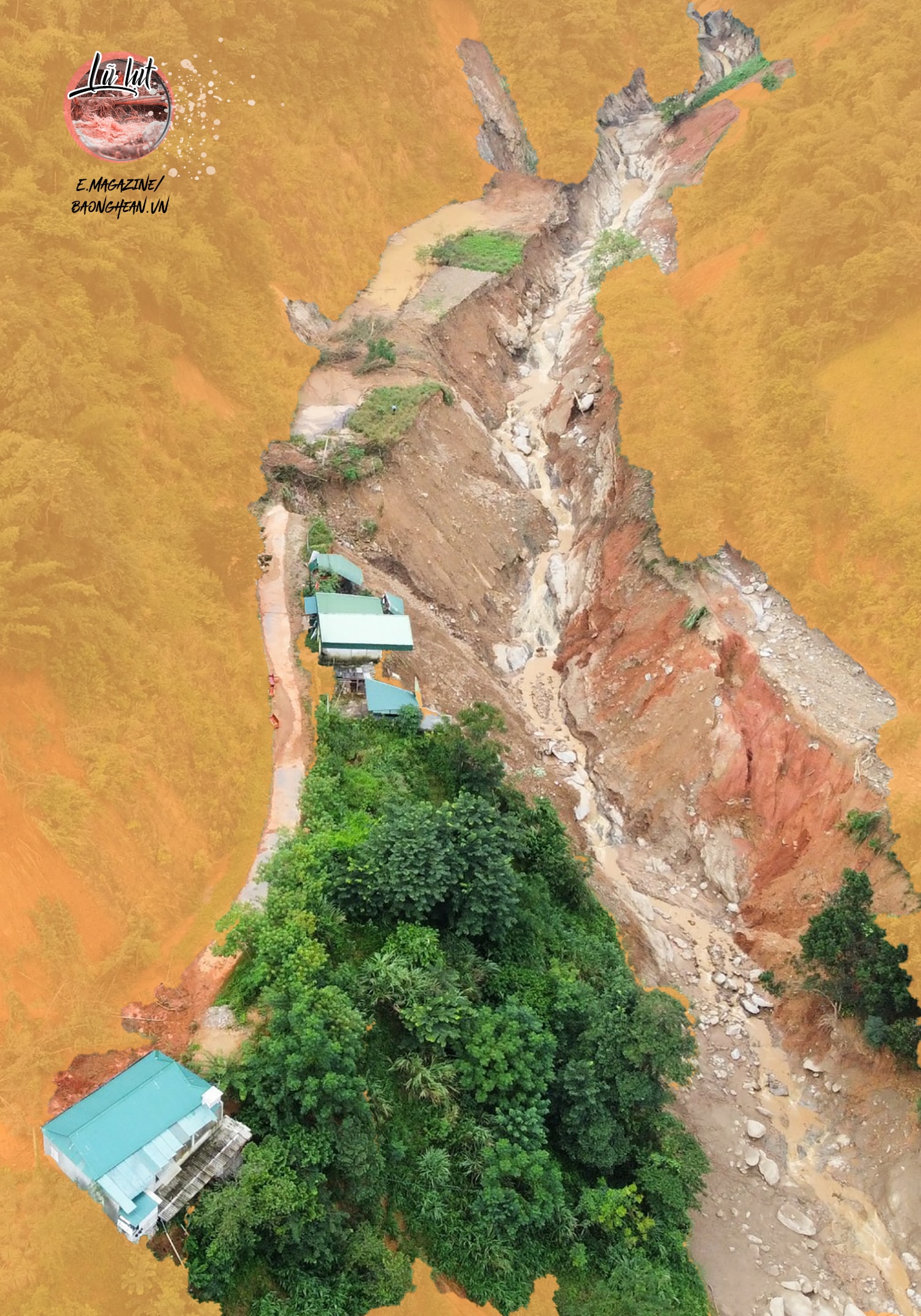
Ten days after the terrible flood occurred in the border district of Ky Son, sweeping away, collapsing, and burying hundreds of houses, offices, and schools, the mountain slopes and roads here continue to show signs of cracks and landslides. By the morning of October 12, 2022, in Hoa Son village, Ta Ca commune - the epicenter of the flash flood, 36 households had to be temporarily evacuated to other places because the mountainous terrain here had many large cracks. In addition, many other houses also began to show cracks across the foundations.
Meeting Mr. Dinh Nho Thanh, a resident of Hoa Son village, Mr. Thanh worriedly said: "Not only the house wall, but the road in front of the house is showing more and more cracks longer than 60m, threatening that the houses along the road can collapse at any time." According to Mr. Vi Van Truyen - Head of Hoa Son village, many households in the village are facing the fear of landslides because the mountain range behind the village has many large cracks running long, even many houses are "split in half" because of subsidence and fractures. To be safe, households are forced to relocate and temporarily take shelter elsewhere.

Statistics from the People's Committee of Ky Son district show that as of October 13, after the flash flood, the entire district had more than 200 houses at risk of collapsing due to landslides, of which 36 houses had to be urgently evacuated, with 20 houses in Hoa Son village alone in high-risk areas. In addition, landslides continued on the mountain slopes of Tay Son - Muong Xen and Ta Ca - Nam Can routes, with rocks and soil falling onto the road, causing traffic jams.
Many years ago, Muong Tip commune, Ky Son district was the "hottest" locality in terms of landslides. There were 138 households living in 3 villages: Xop Phe, Vang Phao, Na My and 20 households in Muong Ai commune living along Nam Mo river. The lives of these households are threatened every day, because of the very high risk of landslides. Although the State has arranged new resettlement areas for these households, it has not been implemented yet.
Every time there is heavy rain, the Nam Mo River flowing through Muong Tip commune becomes fierce, as if it wants to sweep away everything. Notably, the residential area where 158 households live on these mountain slopes has many cracks, at risk of landslides at any time. Many families in Xop Phe village, Muong Tip commune have both the elderly and children, so when it rains heavily for a long time, almost no one dares to sleep at night, for fear of landslides.
Mr. Nguyen Pho Tim - a resident of Xop Phe village, said: My family is among 25 households in the high-risk landslide area. If the State does not soon implement resettlement work for them, during the rainy season, their lives and property will be "hanging by a thread". Although the State has completed the emergency evacuation "field house" for households, the emergency evacuation area is far from the village and the road is difficult. In my opinion, during the rainy season, the authorities and local governments need to closely monitor the weather to proactively plan to evacuate people early, to prevent consequences...
Chairman of Muong Tip Commune People's Committee, Mr. Ha Ba Thai shared: According to the State's plan, these households will be relocated to other safe locations. However, after nearly 5 years of implementation, no households have been resettled yet. Every time the flood season comes, the commune government is always in a state of anxiety, although they assign people to monitor the situation and are ready to support people in case of an incident, they cannot rest assured.

According to Mr. Tho Ba Re - Vice Chairman of the People's Committee of Ky Son district, in addition to 158 households subject to emergency evacuation in the two communes of Muong Tip and Muong Ai, there are hundreds of households in the district located in areas at high risk of damage due to flash floods, landslides in the communes of My Ly, Keng Du, Muong Tip, Ta Ca, Muong Xen, Pha Danh, Nam Can, Chieu Luu, Huu Kiem, Na Ngoi and Huu Lap. However, among them, there are households that need to be relocated to safe resettlement areas, some households with low risk will be relocated on the spot. "This is really a big concern for the locality every time the rainy season comes, because flash floods, landslides happen very quickly, the level of destruction is great, and people have difficulty coping," Mr. Tho Ba Re added.
In Tuong Duong district, there are also some "hot" spots at risk of landslides. Mr. Lo Kham Kha - Head of the District's Department of Agriculture and Rural Development said: The "hottest" spot in Tuong Duong district at present is 53 households of Xop Nam village and the Kindergarten of Tam Hop commune, at the foot of the mountain with an altitude of 611m above sea level, the surface is mainly bushes, bamboo and many large rocks, with a very high risk of landslides. In 2021, due to the influence of storms and rains, landslides have fallen on some houses and the Kindergarten, and the locality is currently very worried about prolonged heavy rain. Tung Huong village of Tam Quang commune has 75 households living at the foot of the high mountain. After prolonged rains and storms, the people here had to evacuate to a safe place because landslides appeared at this location, many rocks with very large mass rolled from the top of the hill to people's houses, causing panic, anxiety, and making people's lives difficult. Through surveys and assessments of the level of danger and risk of landslides, the estimated landslide volume is 56,250 m² of rock and soil.
Que Phong district is also at high risk of flash floods, landslides. Decades ago, there was a serious flash flood in Nam Giai commune, causing heavy damage to people's property. Faced with the reality of unsafe lives and property of people, in 2012, the Provincial People's Committee approved the Emergency Evacuation Project out of the flash flood and landslide area of Quang Phong commune, with a total investment of nearly 45 billion VND. To date, after nearly 9 years of implementation, the district has relocated 23/50 households out of the high-risk area.
Also in Que Phong district, in 2019, the Provincial People's Committee approved the project to relocate 33 households out of areas at risk of flash floods and landslides in Thong Thu commune, with a total investment of nearly 15 billion VND. Up to now, the project has been implementing important items, expected to be completed by the end of 2022. After completion, Que Phong district will relocate all 33 households in Thong Thu commune living in areas at high risk of flash floods to safe places. Thus, at present, in Que Phong district, there are still dozens of households living in areas at high risk of flash floods.
Mr. Bui Van Hien - Vice Chairman of Que Phong District People's Committee is worried: In the district, there are currently hundreds of households living along the river banks, streams and near mountainous areas with high risk of landslides. Of which, the "hottest" are still 50 households in Quang Phong commune and 33 households in Thong Thu commune at risk of being swept away by flash floods. That is why every rainy season, the district warns and guides people to avoid. However, due to unusual natural disasters, each year there is a different type, so it is impossible to predict anything.

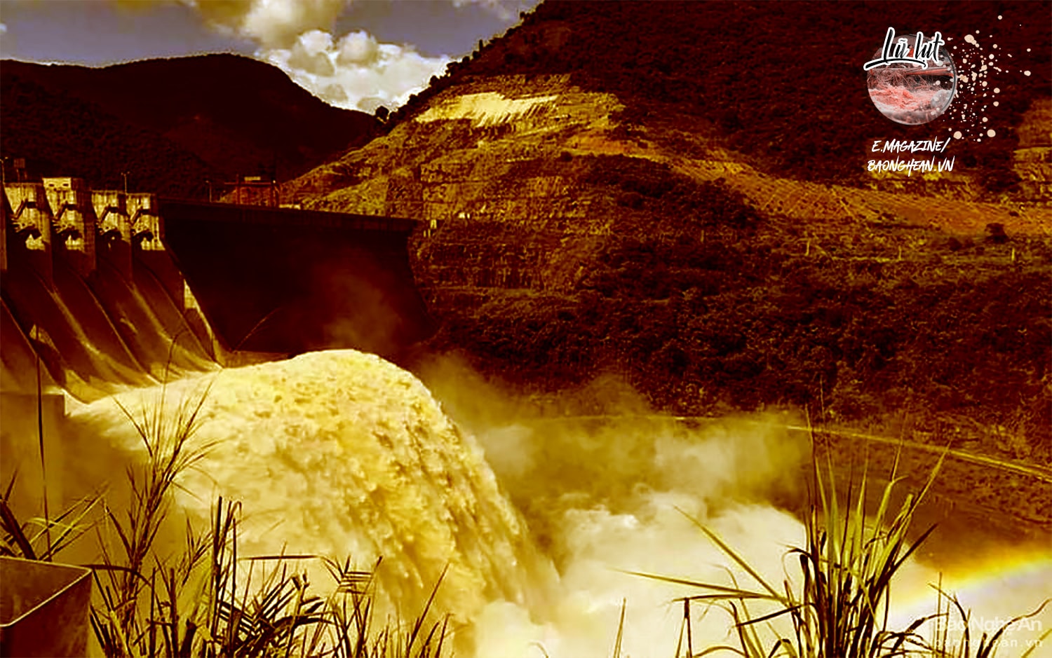
According to the forecast of the hydrometeorological agency, 2022 will be a year with many storms and heavier rainfall than the average year. Therefore, the fact that people live right under the hydroelectric dam area, irrigation with a capacity of tens of millions to billions of cubic meters of water is an issue that needs to be further assessed, seriously identified any possible incidents and soon have feasible prevention solutions.
In recent years, the State has allowed the construction of 13 hydroelectric projects on rivers in the mountainous areas of Nghe An. The appearance of large hydroelectric projects or irrigation dams contributes to regulating water and reducing floods, but also poses many potential risks. Thousands of households living downstream of hydroelectric dams, likened to "giant water bags", cannot help but worry every time the rainy season comes. Hydroelectric power plant releases floodwaters when floodwaters from upstream flow in too large a volume; which means that the lives and property of a segment of the population will be at risk without close coordination between hydroelectric units, local authorities and even the people themselves.
In Xa Luong commune (Tuong Duong), there are two hydroelectric plants built on the Nam Non river, namely Ban Ang Hydroelectric Plant and Nam Non Hydroelectric Plant. When these two hydroelectric projects accumulate water, the people of Xa Luong commune are always in fear, because they live under two "giant water bags". A leader of Xa Luong commune is worried, the commune has 6 villages located under the basin of 2 hydroelectric plants: Ban Ang, Khe Lo, Khe Ngau, Xieng Huong, Cua Rao 1 and Cua Rao 2 village. Although the State has invested in stone embankments in some sections of the Nam Non river, the risk of landslides and flooding is still high every time the hydroelectric plants discharge floodwaters.
Mr. Luong Dinh Viet - Vice Chairman of Con Cuong District People's Committee shared: Although the flood discharge of hydroelectric and irrigation dams follows the inter-reservoir operation process, to ensure the safety of people's lives and property, it is necessary to strengthen information coordination between hydropower management units and the local Flood and Storm Prevention and Control Committee, and seek consultation before flood discharge. In addition to the government's responsibility, hydropower units also strengthen inspections and remind people to avoid rain and floods when working in the fields, and not to fish on the water surface in the hydroelectric dam area when there is a flood discharge notice to limit unfortunate accidents...
Recalling the event of Ban Ve Hydropower Plant having to release a record amount of water at the same time as other hydropower plants, which also caused "floods on floods" in the rainy season of 2018, causing huge damage to the downstream, is the most specific example. Looking at the whole country, the consequences of some hydropower plant releases are that houses, properties, trees, crops, and welfare works in particular of the people are greatly damaged, and it takes a long time to restore.
As mentioned, a major issue is that, in order to minimize risks and damages to the State and people when floods occur, surveying, assessing the extent and determining the cause plays an important role in warning, and at the same time providing feasible plans and solutions. In particular, it is necessary to re-evaluate the capacity of flood drainage systems, dams, river dykes; afforestation, forest protection in the headwaters and of course, the drastic participation of all levels, sectors, and localities is needed...
