Lesson 7: Don't be greedy and throw away the tray
(Baonghean) - At this "final" time, Dien Chau district still has about 500 m/28.03 km of National Highway 1A passing through the area that has not been handed over. In addition to some small problems such as in Dien Yen, Dien Ky, Dien Ngoc, the main reason is that 16 households in Dien Truong commune have not yet handed over the land because they do not agree with the way of calculating the boundary applied to National Highway 1A passing through the commune...
“Street One Hamlet” Dien Truong currently has 80 households living there since 1997. The reason it is called “Street One Hamlet” is because the hamlet consists of households contributed from 20 hamlets in the commune and some households from other areas. Due to the sparse population (only 80 households/248 plots of land), after 20 years, this hamlet has not yet had its administrative boundaries established. Mr. Le Hong Nghia - Chairman of Dien Truong Commune People's Committee said: “To be able to establish an administrative boundary of a hamlet for districts in the delta region, there must be at least 200 households living there. In addition, many other conditions are needed that “Street One Hamlet” does not currently meet. In addition, some households, although living in “Street One Hamlet”, are still under the administrative management of the old hamlet, while households who are citizens from other areas, after registering their household registration in Dien Truong, are allowed to “live together” in adjacent hamlets”. Therefore, although these households are adjacent to each other on the same road, they belong to hamlet 3, hamlet 9, and hamlet 10. If you have to ask for the house of an acquaintance here, it is no different from falling into a "maze". The above complexity and temporary situation has caused difficulties in managing population records and propaganda and mobilization work to implement the State's policies and guidelines for households in "hamlet 1", including the handover of land to implement the project of Upgrading and expanding National Highway 1A.
Therefore, Dien Truong was identified by the local government as a “special” bottleneck in the land clearance work. Therefore, the removal of bottlenecks in Dien Truong area was “left for last”.
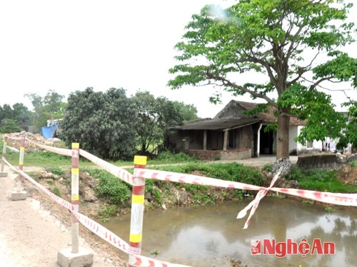
While construction is taking place in other localities, in Dien Truong, construction is temporarily suspended, although there are only about 200m left for this locality to "reach the finish line" in the work of handing over the site. Currently, the authorities and organizations at all levels are actively promoting and mobilizing, but some people still have questions and send complaints to authorities at all levels, even to the National Assembly, with the content: "The Compensation Council for Land Acquisition and Clearance at all levels has violated the procedures and regulations in Decision 04 of the People's Committee of Nghe An province, is not transparent in the compensation area; determining the compensation area does not have a starting point, from the center of the road or from the edge of the old road to the end point is how many meters. When people ask for documents to prove, the officials answer verbally, without basis...". They also said that the Compensation Council for Land Acquisition and Clearance of Dien Chau District determined the area of the PMU1 corridor boundary marker to be 8.5 m from the edge of the road while the general regulation is 13.5 m from the center of the road...
Mr. Chu Van The - a citizen of Hamlet 3, currently living in "Hamlet Road 1" said: "We find that the determination of the area of the PMU1 boundary corridor by the Compensation Council of Dien Chau district is still lacking in basis, because on the plots of land along the same route, some households have a boundary area of up to 11.04 m, some households only have 8.5 m, some households have 10.5 m, so there is a difference in the support level of tens of millions of VND between households". Explaining this issue, Mr. Le Van Thuan - Head of the Department of Natural Resources and Environment of Dien Chau district said: "Currently, we still keep the complete map of the PMU1 clearance period. Therefore, although the current situation has changed, the PMU1 boundary may be relocated, based on that diagram, we can still determine the area of the PMU1 boundary for each household accurately. And there is absolutely no priority for this house, or disadvantage for another house". Mr. Thuan also added that the reason why households think that there is a phenomenon of “sawtooth” shaped boundary markers is because they do not understand, they only observe the length of the route with the naked eye. In fact, for constructions and projects, especially traffic works, the determination of boundary markers must be done using the national “coordinate grid” method.
Accordingly, the "special" terrain location of "street hamlet one" has an embankment higher than the land level of the households, fluctuating from about 1.5m to 2.5m. Therefore, to ensure the safety and stability of the roadbed quality, the PMU 1 boundary marker of the road protection corridor at this route is larger than the section with an unembanked roadbed (the roadbed and the land of the households do not differ in level). The width of the road protection corridor at the routes with embankments where the roadbed is higher than the land level in the affected area is calculated based on the geometric dimensions of each cross-sectional position of the roadbed at the land plots. Specifically, the embankment from the top of the roadbed slope is 1.5 m higher than the land level, then the width of the roadbed must be 2.25 m (in a ratio of 1:1.5), which means that at the location where the land plot is 1.5 m higher than the roadbed, the width of the PMU 1 boundary marker will be 2.25 m + 7 m = 9.25 m; similarly, at locations where the height difference between the roadbed from the roadbed slope and the land is 2.5 m, the width of the roadbed must be 3.75 m, and the width of the PMU 1 boundary marker range is 3.75 m + 7 m = 10.75 m. Therefore, on the same route where the embankment is higher than the land level of the households, a difference of a few meters in the width of the road protection corridor between households is completely normal.
The people's opinion that the method of determining the area of the boundary marker from the centerline of 13.5m must be unified along the entire length of the route is just a subjective inference, without legal basis. According to Official Dispatch No. 1268 PMU1 - QLDA2 dated July 28, 2010 on the implementation of PMU1 QL1A land acquisition work in Nghe An province sent to the Steering Committee for Compensation, Support and Resettlement for the projects to upgrade and expand QL1A through Nghe An province: "The land area from the foot of the construction to the PMU1 land acquisition stake: The sections of the route passing through urban areas are calculated from the outer edge of the longitudinal ditch on each side is 3m, the sections of the route passing through rural areas are calculated from the foot of the embankment embankment and the top of the excavated road embankment embankment on each side is 7m". From the content of the document, it can be seen that the residents' insistence that "the method of determining the boundary area from the center line of 13.5m must be consistent across the entire route" is contrary to current regulations.
 |
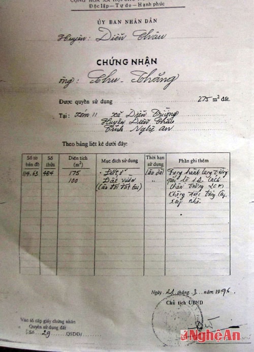
| Land use right certificate of people in "street hamlet 1". |
In addition, based on the data shown on the land use right certificates of the households here, the content in the "additional notes" clearly states: "In the National Highway 1A corridor, 20m from the foot of the road, trees cannot be planted or houses built", showing that the location of "street one hamlet" has been specifically identified as a road traffic safety corridor. However, according to Clause 2, Article 18, Decision 04/2010/QD-UBND dated January 19, 2010 of the People's Committee of Nghe An province: "Houses and other constructions that are not allowed to be built will be supported depending on the level of support", therefore, the Land Acquisition Council of Dien Chau district has provided support to the above households according to regulations. Mr. Le Hong Nghe - Chairman of the People's Committee of Dien Truong commune also said: The Council also flexibly applies support policies that are beneficial to the people, such as immediately paying for assets arising during the measurement and inventory process.
 |
| The handover of the site in Dien Truong (Dien Chau) was delayed. |
Also on the same road in the area, although not really satisfied with the level of support, for the common good, many households have agreed to hand over the land. Mr. Chu Duy Phung said: "Since it is the policy of the Party and the State, we must comply. Although the compensation level is not satisfactory, my family will not make things difficult for the government, because after all, opening the road is to serve the people's lives." In reality, not everyone thinks like that, currently there are still 16 households deliberately not handing over the land because they do not agree with the way the boundary is calculated.
| RELATED NEWS |
|---|
Currently, the deadline for handing over the site is approaching (April 15, 2014). The entire province has handed over 70.82/73.8km, reaching nearly 96%. Many localities in Dien Chau such as Dien An, Dien Phuc, Dien Hong in particular and the entire province such as Quynh Luu, Nghi Loc in general have almost reached the finish line in the work of handing over the site clearance. Local government officials and people of "street one hamlet" cannot, for any reason, cause difficulties or hinder the progress of completing the national key project.
- Yesterday (April 10), Nghi Loc District Land Acquisition Council deployed a plan to protect the construction of 780m of National Highway 1A in hamlets 2,3,6 of Nghi Long commune. In general, the construction protection went smoothly. Thus, with the synchronous and drastic participation of the political system and the consensus of the people, up to this point, Nghi Loc district only has about 30m of National Highway 1A passing through the area that has not yet been handed over. - Also yesterday, in Hoang Mai Town, an additional 1.6km/4km of the remaining land was handed over, and 5 small problems at 3.4km that had been handed over before but had not yet been constructed were resolved. Currently, there is still 1.4km/14.4km of National Highway 1A through Hoang Mai Town that has not yet been handed over. - In Quynh Luu district yesterday, the Compensation Council for Land Acquisition and Site Clearance at all levels handed over 0.7km/1.1km of National Highway 1A passing through Quynh Van commune. Up to this point, Quynh Luu still has 750m of undelivered land, reaching 98.87%. |
PV Group
