Lesson 7: Don't be greedy and lose everything.
(Baonghean) - As the deadline approaches, Dien Chau district still has approximately 500 meters out of 28.03 kilometers of National Highway 1A passing through its territory that have not yet had their land handed over. Besides some minor obstacles in areas like Dien Yen, Dien Ky, and Dien Ngoc, the main reason is that 16 households in Dien Truong commune have refused to hand over their land because they disagree with the method of calculating the boundary lines applied to the section of National Highway 1A passing through the commune…
The "Road One Hamlet" in Dien Truong currently has 80 households, who have been living there since 1997. It's called "Road One Hamlet" because it comprises households from 20 other hamlets in the commune and some households from other areas. Due to its sparse population (only 80 households/248 land plots), this hamlet has not had its administrative boundaries established for 20 years. Mr. Le Hong Nghia, Chairman of the Dien Truong Commune People's Committee, said: "To establish an administrative boundary for a hamlet in lowland districts, there needs to be at least 200 households living there. In addition, many other conditions are required, which the 'Road One Hamlet' currently does not meet. Furthermore, some households, even though they live in the 'Road One Hamlet,' are still under the administrative management of their old hamlet, while those who are citizens from other areas, after registering their household in Dien Truong, are 'joined' in adjacent hamlets." Therefore, even though these households are located next to each other on the same road, some belong to Hamlet 3, some to Hamlet 9, and some to Hamlet 10. If you happen to ask for directions to a friend's house there, it's like getting lost in a maze. This complexity and temporary arrangement has made it difficult to manage population records and to disseminate and promote the implementation of state policies and guidelines to the households in "Hamlet 1," including the handover of land for the National Highway 1A upgrade and expansion project.
Therefore, Dien Truong has been identified by the local authorities as a particularly unique and problematic area in land clearance work. Consequently, resolving the bottlenecks in the Dien Truong area has been "left for last."
While construction is proceeding vigorously in other localities, in Dien Truong, construction has temporarily halted, even though only about 200 meters remain before the land handover is complete. Currently, the government and relevant organizations at all levels are actively campaigning and persuading residents, but some people still have questions and have submitted complaints to various levels of government, even to the National Assembly, with the following content: “The land compensation councils at all levels have violated the procedures and regulations in Decision 04 of the Nghe An Provincial People's Committee, lacking transparency in the compensation area; the compensation area is not clearly defined, not specifying the starting point, whether from the center of the road or from the edge of the old road to the end point in meters. When residents ask for written proof, officials respond verbally, lacking evidence…” They also claimed that the Land Clearance Compensation Council of Dien Chau District had determined the area of the cleared corridor boundary markers for PMU1 to extend up to 8.5 meters from the edge of the road, while the general regulation stipulates 13.5 meters from the center of the road…
Mr. Chu Van The, a resident of Hamlet 3, currently living in "Hamlet 1," stated: "We believe that the determination of the PMU1 boundary corridor area by the Dien Chau District Compensation and Land Clearance Council lacks basis. On plots of land along the same route, some households have boundary markers as large as 11.04 m², some only 8.5 m², and some 10.5 m². This is why there is a difference of tens of millions of dong in compensation between households." Explaining this issue, Mr. Le Van Thuan, Head of the Dien Chau District Department of Natural Resources and Environment, said: "We still retain the complete survey maps from the PMU1 clearance period. Therefore, even though the situation has changed and the PMU1 markers may have been moved, based on those maps, we can still accurately determine the area of the PMU1 boundary markers for each household. There is absolutely no favoritism shown to one household or disadvantage another." Mr. Thuan further explained that the residents' perception of the "sawtooth" shape of the boundary markers stems from a misunderstanding; they only observed the length of the route with the naked eye. In reality, for construction projects, especially transportation projects, the determination of boundary markers must be carried out using the national "coordinate grid" method.
Accordingly, the "unique" topographical location of "Roadside Hamlet 1" has an embankment road that is unevenly higher than the ground level of the households' land plots, ranging from approximately 1.5m to 2.5m. Therefore, to ensure the safety and stability of the roadbed, the PMU 1 boundary marker of the road protection corridor on this section is larger than the section with an unembanked roadbed (where the roadbed and the households' land plots are not significantly different in level). The width of the road protection corridor on roads with embankments where the roadbed is higher than the ground level of the land plots in the affected area is calculated based on the geometric dimensions of each cross-section of the roadbed at each land plot. Specifically, if the embankment is 1.5m higher than the land plot level from the top of the embankment slope, the width of the embankment must be 2.25m (according to a ratio of 1:1.5). This means that at locations where the land plot is 1.5m higher than the embankment, the width of the PMU 1 boundary marker will be 2.25m + 7m = 9.25m. Similarly, at locations where the elevation difference between the embankment and the land plot is 2.5m, the width of the embankment must be 3.75m, and the width of the PMU 1 boundary marker will be 3.75m + 7m = 10.75m. Therefore, on the same route where the embankment is higher than the land plot level of the households, a difference of a few meters in the width of the road protection corridor between households is completely normal.
Furthermore, the public's assertion that the method of determining the boundary marker area from the centerline at 13.5m must be standardized along the entire length of the route is merely subjective speculation and lacks legal basis. According to Official Letter No. 1268 PMU1 – QLDA2 dated July 28, 2010, regarding the implementation of land clearance work for PMU1 on National Highway 1A in Nghe An province, sent to the Steering Committee for Compensation, Support and Resettlement for the National Highway 1A upgrading and expansion projects in Nghe An province: “The land area from the base of the structure to the PMU1 land clearance marker: For sections passing through urban areas, the area is calculated from the outer edge of the roadside ditch to each side as 3m; for sections passing through rural areas, the area is calculated from the base of the embankment slope to the top of the excavated road embankment slope to each side as 7m.” The content of the official document shows that the residents' insistence that "the method of determining the boundary marker area from the centerline, which is 13.5m, must be standardized along the entire line" is contrary to current regulations.
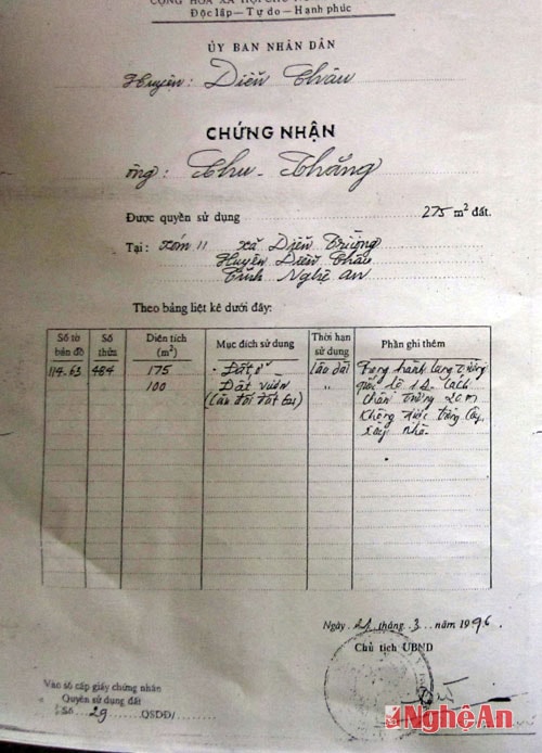 |
| Land use right certificates for residents of "Hamlet 1". |
Furthermore, based on the data shown on the land use right certificates of the households here, the "additional notes" clearly state: "No planting trees or building houses is allowed within 20 meters of the road's edge of National Highway 1A," indicating that the area belonging to "Road One Hamlet" has been specifically defined as a road safety protection corridor. However, according to Clause 2, Article 18 of Decision 04/2010/QD-UBND dated January 19, 2010, of the People's Committee of Nghe An province: "Houses and other structures not permitted to be built will be compensated depending on the extent," therefore, the Land Clearance Council of Dien Chau district has provided support to the aforementioned households in accordance with regulations. Mr. Le Hong Nghe - Chairman of the People's Committee of Dien Truong commune - also stated that the Council has flexibly applied support policies beneficial to the people, such as immediately paying for any assets arising during the surveying and inventory process.
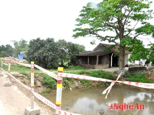 |
| The handover of the land in Dien Truong (Dien Chau) has been delayed. |
Along the same road in the area, although not entirely satisfied with the compensation, many households have agreed to hand over their land for the common good. Mr. Chu Duy Phung said: "Since it is a policy of the Party and the State, we must comply, even though the compensation is not satisfactory. My family will not cause any difficulties for the authorities, because ultimately, building roads is to serve the people." In reality, not everyone thinks this way. Currently, there are still 16 households deliberately refusing to hand over their land because they disagree with the way the boundary markers are calculated.
| RELATED NEWS |
|---|
Currently, the deadline for land handover is approaching (April 15, 2014). The entire province has handed over 70.82/73.8km, reaching nearly 96%. Many localities in Dien Chau district, such as Dien An, Dien Phuc, and Dien Hong, and throughout the province, such as Quynh Luu and Nghi Loc, are close to completing the land clearance process. Local government officials and residents of the "Road One Hamlet" cannot, for any reason, create difficulties or hinder the completion progress of this key national project.
- Yesterday (April 10th), the Nghi Loc District Land Clearance Council implemented a plan to protect the construction work along 780 meters of National Highway 1A in hamlets 2, 3, and 6 of Nghi Long commune. Overall, the protection of the construction proceeded smoothly. Thus, with the coordinated and decisive involvement of the political system and the consensus of the people, Nghi Loc district now only has about 30 meters of National Highway 1A remaining that has not yet been handed over. - Also yesterday, in Hoang Mai Town, an additional 1.6km out of the remaining 4km was handed over, and 5 minor obstacles were resolved along the previously handed-over 3.4km that had not yet been constructed. Currently, 1.4km out of 14.4km of National Highway 1A section through Hoang Mai Town still has not had its land handed over. - In Quynh Luu district yesterday, the land compensation and clearance councils at all levels handed over 0.7km out of 1.1km of the National Highway 1A route passing through Quynh Van commune. As of now, Quynh Luu still has 750m of land to be handed over, reaching 98.87%. |
Reporters' Team

