Exposing China's non-existent trip to Hoang Sa
The non-existent 1902 expedition has been written into the history books. This fact was exposed by the French geographer François-Xavier Bonnet.
It is hardly surprising that English-language articles on the dispute, written by Chinese authors and based on Chinese sources, tend to be pro-Chinese.
Cheng assessed that "it is safe to say that China's claim to sovereignty over the South China Sea archipelagos is stronger. Chiu and Park concluded, "China's claim to sovereignty over the Paracel and Spratly Islands is stronger than Vietnam's claim."
Author Shen's viewpoint is clearly expressed in the titles of the articles: "International legal principles and historical evidence supporting China's nominal sovereignty over the archipelagos in the East Sea" and "China's sovereignty over the archipelagos in the East Sea".
These observations remain influential today: for example, they are cited in the 2014 papers by Li and Tan. However, a closer examination of the evidence on which these papers are based reveals that they are not entirely reliable. Journal articles from 1933, 1956, and 1974 should not be taken as neutral evidence, but as a biased reading of a contested history.
The scope of this article is not sufficient to cover all the authors’ claims about events before the 19th century. In summary, the articles by Cheng, Chiu and Park, Samuels and Shen all share the common view that China has always been the dominant power in terms of shipping, trade and fisheries in the South China Sea.
For example, Cheng wrote that, "It [the South China Sea] has been an important part of the sea route from Europe to the East since the 16th century, a paradise for fishermen from Hainan Island and a gateway for Chinese traders from southern China to Southeast Asia since ancient times."
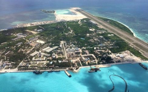 |
| China brazenly released photos of the newly built runway on Phu Lam Island in Vietnam's Hoang Sa archipelago (Internet source). |
But more empirical studies of the history of the South China Sea suggest that the situation was much more complex. Works by historians Leonard Blussé, Derek Heng, Pierre-Yves Manguin, Roderich Ptak, Angela Schottenhammer, Li Tana, Nicholas Tarling, and Geoff Wade have shown that multiple states were involved in the use of the sea in pre-modern times.
Chinese ships and merchants played virtually no role in maritime trade until the 10th century, and even then they never had any dominance over the sea, which was shared by Malays, Indians, Arabs and Europeans. Research by François-Xavier Bonnet, Ulises Granados and Stein Tonnesson has shown how similar conditions persisted in the region well into the 20th century.
According to records from the early 20th century, the Chinese state had great difficulty even controlling its own coastline and was completely unable to extend control to archipelagos hundreds of miles offshore.
For example, two articles in The Times of London from January 1908 described the inability of Chinese authorities to control piracy on the Xijiang River.
A 1909 article in the Australian newspaper The Examiner reported that foreigners ("two Germans, a Japanese and several Malays") had begun mining operations on Hainan Island without the knowledge of Chinese authorities until much later.
What these contemporary records show is that, until the mid-20th century, the South China Sea remained essentially ungoverned, except for occasional interventions by foreign powers to combat piracy.
It was not until 1909, following the scandal surrounding the occupation of the Dongsha Islands by Japanese fertilizer businessman Nishizawa Yoshiji, that Chinese authorities began to take an interest in the offshore islands.
On the 1887 Border Treaty
However, Samuels argues that a covert Chinese claim to the Spratly Islands may have been made as early as 1883, when, according to his account, the Ming government formally protested a German-sponsored expedition to the islands. The only basis for this assertion is an article in the May 1974 edition of the Hong Kong-based Ming Pao Monthly, without any other corroborating evidence.
Chiu and Park (in footnote 47) also rely on an article published in a 1933 issue of the Diplomatic Monthly, 50 years after the above-mentioned questionable events occurred. Heinzig and Samuels later also cited this issue of Ming Pao Monthly when stating that the 1883 German expedition actually had to withdraw following Chinese protests.
The above claim seems highly unlikely, as German explorers mapped the Paracel Islands (not the Spratly Islands) between 1881 and 1883, completed their work, and then published a chart. The French edition was published in 1885.
Samuels writes, The 1887 Sino-Tonkin Border Treaty negotiated by the French government, nominally representing northern Vietnam, has the value of an international agreement dividing the islands for China. Article 3 of the Treaty actually divided the islands east of the Paris meridian 105°43' for China.
However, Samuels and other authors failed to note that the Treaty only applied to Tonkin - present-day northern Vietnam - and thus could only relate to the islands in the Gulf of Tonkin.
The Paracel and Spratly Islands, located much further south, in what was then the domain of Annam (central Vietnam under the rule of the Hue court) and Cochinchina, were not mentioned in the Treaty.
The 1902 journey?
There also appears to be some confusion about the timing of the first visit by Chinese officials to the Paracel Islands.
Based on his 1974 Ming Pao Monthly article, Samuels dates the date to 1902, with a return voyage in 1908. Austin and Dzurek also follow Samuels on this point. Li and Tan (2014) also assert a 1902 claim, along with a separate expedition in 1907.
Cheng again dates the year to 1907, based on the 1933 references mentioned by Chiu and Park, namely a 1933 edition of the National Literature Weekly. However, in contrast to these accounts, which were written 26–72 years after the events they describe, a survey of contemporary newspapers clearly shows that the first expedition by Chinese officials to the Paracels was in 1909.
There is good reason for the confusion over the 1902 expedition. In June 1937, the head of China's 9th administrative region, Huang Qiang, was sent on a secret mission to the Paracels, in part to check whether there was Japanese activity on the islands.
However, Hoang had another role, made clear in a secret appendix to his report.
An excerpt of this appendix was published in Chinese by the Guangdong Provincial Place Names Committee in 1987. His boat carried 30 stone markers, some dated 1902, others 1912, and the rest 1921.
On North Island, he buried two milestones dated 1902 and four milestones dated 1912; on Linh Chau Island, Mr. Hoang's group buried one milestone dated 1902, one milestone dated 1912 and one milestone dated 1921. On Phu Lam Island, they buried two milestones dated 1921. Finally, on Da Island, they buried one milestone dated 1912.
The landmarks were forgotten until 1974, when, after the Paracel War, they were found and this "discovery" was announced in Hong Kong newspapers, such as Ming Pao Monthly.
This non-existent 1902 expedition was later consigned to the history books. It was only recently that the truth was revealed by French geographer François-Xavier Bonnet.
(According to VNN)
| RELATED NEWS |
|---|