Storm No. 4 - Bebinca level 11, 450km from Vinh city (Nghe An)
(Baonghean.vn) - According to the 5am news this morning (August 16) of the National Center for Hydro-Meteorological Forecasting, storm No. 4 has passed the Leizhou peninsula and entered the eastern part of the Gulf of Tonkin.
At 4 o'clock,The center of the storm is located at about 20.6 degrees North latitude; 109.4 degrees East longitude, 210km from Mong Cai, 320km from Thai Binh, 450km from Vinh. The strongest wind near the center of the storm is level 9 (75-90km/hour).level 11. The range of strong winds of level 6, gusting to level 8 is about 110km from the center of the storm.
Forecast for the next 24 hours,The storm is moving in a West-Southwest direction, traveling about 10km per hour. At 4:00 a.m. on August 17, the center of the storm was at about 20.1 degrees North latitude; 106.9 degrees East longitude, right on the sea of the provinces from Quang Ninh to Nghe An. The strongest wind near the center of the storm is level 8-9 (60-90km/hour).level 11. The range of strong winds of level 6, gusting to level 8 is about 100km from the center of the storm.
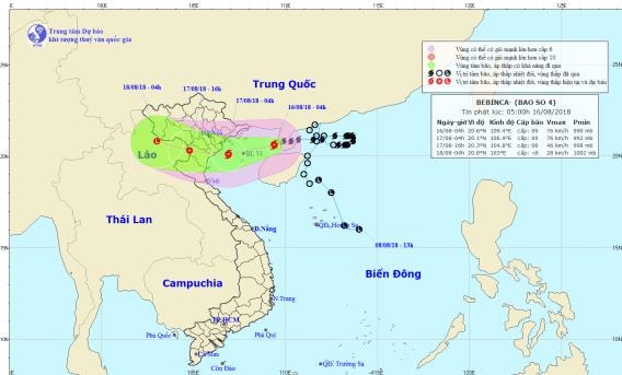 |
| Storm path and location. Photo: National Center for Hydro-Meteorological Forecasting |
Due to the influence of the storm, in the Gulf of Tonkin there will be stormy rain, strong winds of level 6-7, and areas near the storm's eye will have winds of level 8-9.level 11In Bach Long Vi and Co To island districts, from noon and afternoon, the wind gradually increases to level 6-7, then increases to level 8-9.level 11. Waves in the Gulf of Tonkin are 2-4m high, the sea is very rough.
Dangerous areas at sea in the next 24 hours (strong wind level 6 or higher): the entire sea area north of the Gulf of Tonkin (north of latitude 19.0 degrees North).
Over the next 24 to 36 hours,The storm is moving west at about 10km per hour;From midnight tonight to noon tomorrow (August 17), the storm center with strong winds of level 8, gusting to level 10 will directly affect the provinces from Quang Ninh to Nghe An, after which the storm will move deep inland and weaken into a tropical depression..
At 4:00 p.m. on August 17, the center of the tropical depression was at about 20.3 degrees North latitude; 104.8 degrees East longitude, on the mainland of Thanh Hoa area. The strongest wind near the center of the tropical depression was level 6 (40-50km/h).level 8 jerk. The range of strong winds of level 6, gusting to level 8 is about 60km from the center of the tropical depression.
Due to the influence of the storm, from tonight on the mainland coastal areas of Quang Ninh, Hai Phong, Thai Binh, Nam Dinh, Ninh Binh, Thanh Hoa, Nghe An provinces, the wind will gradually increase to level 6, from early tomorrow morning it will increase to level 7.level 9; Thai Binh, Nam Dinh, Ninh Binh, and North Thanh Hoa have strong storm winds of level 7-8,level 10.
Over the next 36 to 48 hours,The tropical depression moved in a West Northwest direction, about 10km per hour, went inland and weakened into a low pressure area.Storm disaster risk level: level 3.
Warning of heavy rain and rough seas:
From now until August 18, in the Northern and North Central provinces, there will be heavy to very heavy rain (rainfall 250-350mm/period), the focus of very heavy rain is concentrated in the Northeast region, the Northern Delta and midlands, the provinces of Son La, Hoa Binh, Thanh Hoa, Nghe An; in particularHoa Binh and Thanh Hoa are likely to have exceptionally heavy rain (400-500mm/period).Hanoi has very heavy rain (common rainfall 200-300mm/period).
From August 16-18, in the North and North Central regions, there will be a flood, with flood levels rising 2-4m on the Red River-Thai Binh and Hoang Long River systems, and 3-6m on rivers in Thanh Hoa and Nghe An.
During this flood, the flood peak on the Da River and the downstream of the Ma River will rise to level 1-2; the Thao River, Hoang Long River, Bui River, and the upstream of the Ma River are likely to rise to level 2-3, while the Buoi River will rise to level 3 and above 3; and the upstream of the Thai Binh River will be at level 1.
There is a high risk of landslides and flash floods in the mountainous areas of the North and North Central regions, especially in the provinces of Lai Chau, Son La, Hoa Binh, Yen Bai, Phu Tho, Quang Ninh, Lang Son, Cao Bang, Thanh Hoa, Nghe An. Flooding in low-lying areas and urban areas in the Northern Delta, Thanh Hoa, Nghe An.Disaster risk level due to heavy rain, flooding, flash floods, landslides: level 2.
In addition, due to the influence of the tropical convergence zone combined with the strong southwest monsoon, during today and tonight (August 16), in the Central and Southern East Sea (including the waters of Truong Sa archipelago), the waters from Binh Thuan to Ca Mau will continue to have strong southwest winds of level 6-7,jerky9, waves 2-4m high; rough sea.
The sea area from Ca Mau to Kien Giang and the Gulf of Thailand has heavy thunderstorms; during thunderstorms there is a possibility of tornadoes and strong gusts of wind.
Disaster risk level due to strong winds and big waves in the southern sea: level 1.