
Typhoon No. 4 - Bebinca, with gusts reaching level 11, is located 450km from Vinh City (Nghe An province).
(Baonghean.vn) - According to the 5:00 AM news bulletin this morning (August 16th) from the Central Meteorological and Hydrological Forecasting Center, Typhoon No. 4 has crossed the Leizhou Peninsula and entered the eastern part of the Gulf of Tonkin.
At 4 o'clock,The storm's center is located at approximately 20.6 degrees North latitude and 109.4 degrees East longitude, 210km from Mong Cai, 320km from Thai Binh, and 450km from Vinh. The strongest winds near the storm's center are at level 9 (75-90 km/h).level 11The area of strong winds (level 6, gusting to level 8) extends approximately 110km from the storm's center.
Forecast for the next 24 hours,The storm is moving in a west-southwest direction at approximately 10 km per hour. By 04:00 on August 17th, the storm's center was located at approximately 20.1 degrees North latitude and 106.9 degrees East longitude, directly over the sea off the coast of provinces from Quang Ninh to Nghe An. The strongest winds near the storm's center were at force 8-9 (60-90 km/hour).level 11The area of strong winds (level 6, gusting to level 8) extends approximately 100km from the storm's center.
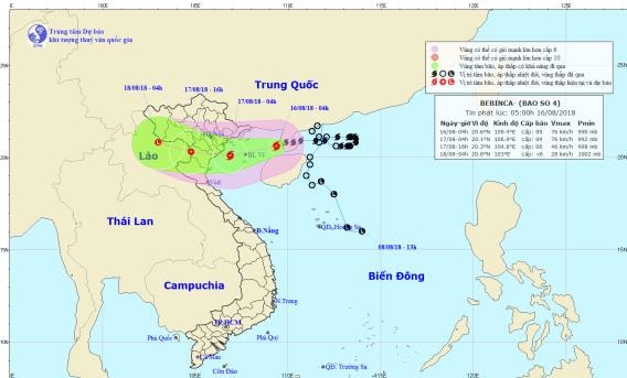 |
| The path and location of the storm. Photo: National Center for Hydro-Meteorological Forecasting. |
Due to the influence of the storm, there will be stormy weather in the Gulf of Tonkin, with strong winds of force 6-7, and winds of force 8-9 in areas near the storm's center.level 11In the island districts of Bach Long Vi and Co To, the wind will gradually strengthen to level 6-7 from noon and afternoon, then increase to level 8-9.level 11The waves in the Gulf of Tonkin are 2-4 meters high, and the sea is very rough.
Hazardous areas at sea over the next 24 hours (areas with winds of force 6 or higher): the entire northern part of the Gulf of Tonkin (north of 19.0 degrees North latitude).
Over the next 24 to 36 hours,The storm is moving westward at a speed of about 10 km per hour;From midnight tonight until noon tomorrow (August 17th), the storm's center, with wind speeds of level 8 and gusts of level 10, will directly affect the provinces from Quang Ninh to Nghe An. Afterwards, the storm will move further inland and weaken into a tropical depression..
As of 4 PM on August 17th, the center of the tropical depression was located at approximately 20.3 degrees North latitude and 104.8 degrees East longitude, over land in the Thanh Hoa area. The strongest winds near the center of the tropical depression were at level 6 (40-50 km/h).level 8 gustThe area of strong winds (level 6, gusting to level 8) extends approximately 60km from the center of the tropical depression.
Due to the influence of the storm, from tonight onwards, strong winds will gradually increase to level 6 in the coastal areas of Quang Ninh, Hai Phong, Thai Binh, Nam Dinh, Ninh Binh, Thanh Hoa, and Nghe An provinces, and increase to level 7 from early tomorrow morning.level 9 gustSpecifically, Thai Binh, Nam Dinh, Ninh Binh, and northern Thanh Hoa experienced strong winds and storms of level 7-8.level 10 surge.
Over the next 36 to 48 hours,The tropical depression moved in a west-northwest direction at a speed of about 10 km per hour, moving further inland and weakening into a low-pressure area.Level of natural disaster risk due to storms: level 3.
Warning of heavy rain and rough seas:
From now until August 18th, heavy to very heavy rain (250-350mm/period) is expected in the Northern and North Central provinces, with the heaviest rainfall concentrated in the Northeast region, the Northern delta and midland areas, and the provinces of Son La, Hoa Binh, Thanh Hoa, and Nghe An.Hoa Binh and Thanh Hoa provinces are likely to experience exceptionally heavy rainfall (400-500mm/event).Hanoi experienced very heavy rainfall (commonly 200-300mm per event).
From August 16-18, a flood will occur in Northern Vietnam and North Central Vietnam, with flood levels rising by 2-4m on the Red River-Thai Binh River system and the Hoang Long River, and by 3-6m on rivers in Thanh Hoa and Nghe An provinces.
During this flood event, the flood peaks on the Da River and the lower reaches of the Ma River reached levels BĐ1-BĐ2; the Thao River, Hoang Long River, Bui River, and the upper reaches of the Ma River are likely to reach levels BĐ2-BĐ3, while the Buoi River will reach level BĐ3 and above; the upper reaches of the Thai Binh River will be at level BĐ1.
There is a high risk of landslides and flash floods in the mountainous areas of Northern and North Central Vietnam, especially in provinces such as Lai Chau, Son La, Hoa Binh, Yen Bai, Phu Tho, Quang Ninh, Lang Son, Cao Bang, Thanh Hoa, and Nghe An. Flooding is also expected in low-lying areas and urban centers in the Northern Delta, Thanh Hoa, and Nghe An.Level of risk from natural disasters due to heavy rain, flooding, flash floods, and landslides: level 2.
Furthermore, due to the influence of the tropical convergence zone combined with strong southwest monsoon winds, during today and tonight (August 16th), the central and southern areas of the East Sea (including the waters around the Truong Sa archipelago), and the sea area from Binh Thuan to Ca Mau will continue to experience strong southwest winds of force 6-7.escalating9The waves are 2-4 meters high; the sea is very rough.
The sea area from Ca Mau to Kien Giang and the Gulf of Thailand will experience heavy thunderstorms; tornadoes and strong gusts of wind are possible during the thunderstorms.
Level of natural disaster risk due to strong winds and high waves in the southern sea area: level 1.


