(Baonghean.vn) - Before typhoon No. 10 made landfall, many areas of Nghe An experienced heavy to very heavy rain.
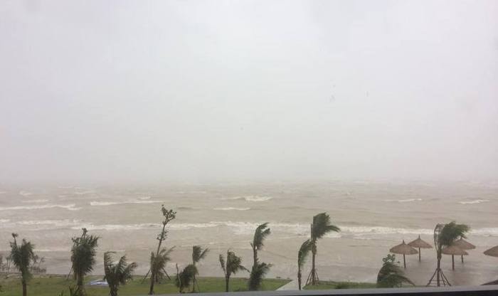 |
| The sea is very rough at Cua Hoi. Photo: Nguyen Dinh Chien. |
According to the Central Meteorological and Hydrological Forecasting Center, at 04:00 on September 15th, the typhoon's center was located at approximately 17.4 degrees North latitude and 108.2 degrees East longitude, about 190km east-southeast of the coast of provinces from Ha Tinh to Quang Binh. The strongest winds near the center of the typhoon were at level 12-13 (115-150 km/h), with gusts up to level 15.
Forecast for the next 12 hours,The storm is moving in a west-northwest direction at a speed of 20-25 km per hour.
From around noon to afternoon today (September 15th),The eye of typhoon number 10 will move inland into the provinces from Nghe An to Quang Tri, causing strong winds of level 11-12, gusting to level 15.
By 4 PM on September 15th,The storm's center is located at approximately 18.0 degrees North latitude and 105.9 degrees East longitude, over the land area of provinces from Nghe An to Quang Tri. The strongest winds near the storm's center are at level 11 (100 to 115 km/hour), with gusts up to level 14.
Forecasts indicate that over the next 12 to 24 hours, the storm will continue to move west-northwest at a speed of 20-25 km/h, moving further inland before weakening into a tropical depression over Upper Laos.
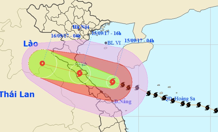 |
| The latest path of the storm. Photo: nchmf |
 |
| Deputy Prime Minister Trinh Dinh Dung requested Nghe An province to closely monitor the storm's developments in order to proactively respond. Photo: MH |
Warning at sea:Due to the influence of the storm, strong winds of level 8-9 are expected in the sea areas from Quang Tri to Quang Ngai (including Con Co Island, Cu Lao Cham, and Ly Son Island), increasing to level 10-11 this morning, and reaching level 12-13 in areas near the storm's center, with gusts up to level 15, causing extremely rough seas (Natural disaster risk level: level 4).
The sea area from Thanh Hoa to Quang Binh (including Hon Ngu Island), and the Gulf of Tonkin will experience strong winds of force 6-8, later increasing to force 10-11, with winds near the storm's center reaching force 12, gusting to force 15; the sea will be extremely rough (Natural disaster risk level: level 4).
Offshore waves in the storm's center are over 10m high, and 5-6m near the shore. Storm surge along the coast from Hai Phong to Quang Binh is likely to exceed 1.0m, and around 2.0m in the coastal area from Thanh Hoa to Ha Tinh.
Strong wind warning on land:From this morning (September 15th), strong winds of force 7-9 are expected along the coastal areas of Nghe An, Ha Tinh, Quang Binh, and Quang Tri provinces, increasing to force 10-11 near noon, reaching force 12 with gusts up to force 15 in areas near the storm's center (natural disaster risk level: level 4); further inland areas will experience strong winds of force 8-9 with gusts up to force 12. Coastal areas of Quang Ninh, Hai Phong, Thua Thien Hue, and Da Nang provinces will experience strong winds of force 6-7 with gusts up to force 9; coastal areas of Thai Binh, Ninh Binh, Nam Dinh, and Thanh Hoa provinces will experience strong winds of force 8 with gusts up to force 11 (natural disaster risk level: level 3).
Heavy rain warning:By the end of the night of September 15th, heavy to very heavy rain (100-300mm/period) continued in the provinces from Quang Ngai to Nghe An, with some areas in Ha Tinh, Quang Binh, and Quang Tri receiving over 400mm;
From this morning until the end of September 16th, Thanh Hoa, the southern provinces of the Northern Delta, Hoa Binh and Son La will experience moderate to heavy rainfall (50-150mm, with some areas exceeding 200mm).
Warning of floods, flash floods, landslides, and waterlogging:From now until September 17th, a flood event will occur on rivers from Thanh Hoa to Quang Ngai. There is a high risk of flash floods, landslides, and localized flooding in Hoa Binh, Son La, and the provinces from Thanh Hoa to Thua Thien Hue.
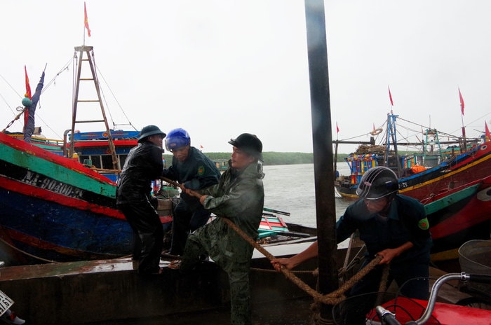 |
| Militia members of Dien Ngoc commune help residents moor their boats. Photo: Trong Kien. |
According to Nghe An Newspaper, before the storm made landfall, many areas in the province experienced heavy rain and strong winds. The sea in Cua Lo and Cua Hoi areas was very rough.
The Standing Office of the Steering Committee for Disaster Prevention and Search and Rescue of Nghe An province reported that by 6 PM yesterday (September 14), all ships and boats at sea off Nghe An had safely taken shelter from Typhoon No. 10; including: 3,912 vessels/17,848 workers anchored at ports; and 104 vessels/693 workers anchored outside the province.
In the coastal town of Cua Lo,Following the instructions of the Chairman of the People's Committee of the town, on the night of September 14th, all 350 kiosks along the beach transported their belongings back home, reinforced their corrugated iron roofs, and dismantled advertising signs to minimize damage should typhoon No. 10 make landfall.
In Quynh Luu district,Fifty officers and soldiers from the Quỳnh Lưu District Military Command were divided into 7 working groups to go to 7 clusters in the district to help people reinforce their houses, trim large trees, etc., to prepare for typhoon number 10.
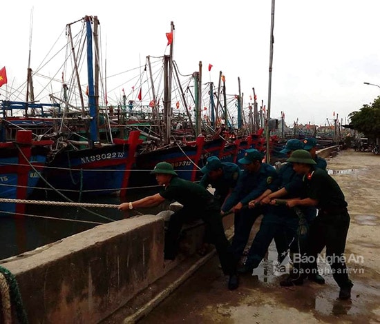 |
| Officers and soldiers of the Quỳnh Lưu District Military Command help the people of Sơn Hải secure their boats. Photo: Hồng Diện. |
 |
| Helping people in Quynh Hau clear out materials and cement into warehouses and houses before the storm arrives. Photo: Hong Dien. |
Currently, all boats and ships from Quynh Luu have returned to safe anchorage locations.
 |
| People in Quynh Luu protect their roofs with sandbags. Photo: Hong Dien. |
In Nghi Loc district,The Nghi Loc District Search and Rescue Command directed all officials to remain on-site. Many coastal communes have evacuated residents. Specifically, Phuc Tho commune evacuated 105 households/261 people from hamlets 17, Binh Minh, Ngu Phong, and 6; Nghi Thuan commune evacuated 70 households/123 people bordering the Cam River that were flooded; Nghi Thai commune evacuated households along the river; Nghi Tien commune had 90 households/302 people in hamlet 5 isolated; Nghi Quang commune evacuated 97 households/520 people from dangerous areas; Nghi Thiet commune evacuated 24 households in Rong, Bac Thinh, and Nam Thinh hamlets...
N.Khoa - H.Diện - N.Tuấn
| RELATED NEWS |
|---|






















Governing body: Nghe An Provincial Party Committee
Director: Tran Minh Ngoc
Electronic newspaper operating license number: 153/GP-BTTTT
Issued by the Ministry of Information and Communications on March 24, 2022