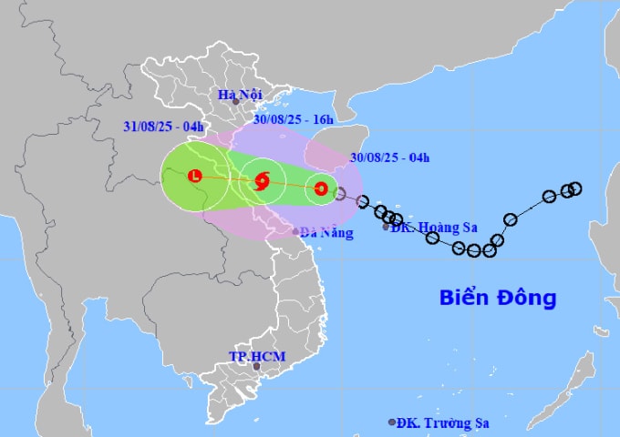
Tropical depression intensifies into a storm, causing heavy rain in Nghe An.
This morning, the tropical depression intensified into a storm, reaching level 8, causing heavy rain in Nghe An and Quang Tri provinces, with total rainfall over two days potentially reaching 500 mm.
According to the National Center for Meteorological and Hydrological Forecasting, at 7:00 AM, when it was about 240 km north of Quang Tri and about 190 km from Hue City, the tropical depression strengthened into a typhoon, the sixth typhoon in the East Sea.
Currently, the storm's strongest winds are 74 km/h, level 8, with gusts up to level 10, and it is moving west-northwest at a speed of 20 km/h. By tonight, the storm will make landfall in Quang Tri - Hue and weaken into a low-pressure area in central Laos.
In Ha Tinh, from 6 am today, there have been intermittent showers with light winds. Many vehicles are still moving normally on the streets that were formerly part of Ha Tinh City. Coastal communes are experiencing light rain. In Nghe An, heavy rain fell on the night of August 29th in the central wards that were formerly part of Vinh City; the rain has stopped this morning, but the sky remains overcast.
The meteorological agencies of Japan and Hong Kong both assess that the tropical depression, after strengthening into a storm, will not intensify further. The storm is expected to make landfall in Quang Tri and Hue provinces sometime tonight or early tomorrow morning.

The northwestern coastal area of the East Sea (including the Hoang Sa Special Economic Zone) will experience strong winds of force 6-7, with waves 2-4.5 meters high. The sea area from Thanh Hoa to Hue (including Hon Ngu Island and Con Co Special Economic Zone) will see winds gradually increasing to force 6-7, reaching force 8 with gusts up to force 10 near the storm's center; waves will be 2-4 meters high, and 3-5 meters near the storm's center. The coastal areas of Nghe An and Hue provinces will experience storm surge of 0.2-0.4 meters.
"The weather at sea and in coastal areas is very dangerous and unsafe for vessels and structures to operate," the meteorological agency warned.
On land, from this morning, winds along the coast of Nghe An - Quang Tri have gradually increased to level 6, gusting to level 8. Specifically, along the coast of Ha Tinh - northern Quang Tri, winds are at level 6-7, near the storm's center at level 8, gusting to level 10, and strong thunderstorms and tornadoes may occur before the tropical depression or storm directly impacts the area.
From now until the end of tomorrow, Thanh Hoa and Hue will receive 150-300 mm of rain, with some areas exceeding 500 mm; the midland and lowland areas of Northern Vietnam and Da Nang will receive 100-200 mm, with some places exceeding 400 mm.