
Typhoon Kai-tak is entering the South China Sea, and its development is becoming increasingly complex.
The center of Typhoon Kai-tak is located approximately 250km east of the central coast of the Philippines. The strongest winds near the center of the typhoon are at level 8, with gusts up to level 10.
According to the National Center for Hydrometeorology, at 13:00 (December 15th), the center of Typhoon Kai-tak was located at approximately 11.7 degrees North latitude and 127.6 degrees East longitude, about 250km east of the central coast of the Philippines. The strongest winds near the center of the typhoon were at level 8 (60-75km/hour), with gusts up to level 10.
Forecasts for the next 24 hours indicate that Typhoon Kai-tak will move slowly in a west-northwest direction at a speed of 5 km per hour. By 13:00 on December 16th, the typhoon's center will be located at approximately 12.4 degrees North latitude and 126.1 degrees East longitude, over the sea east of central the Philippines. The strongest winds near the center of the typhoon will be at force 8-9 (60-90 km/hour), with gusts up to force 11.
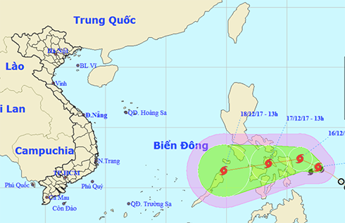 |
| The location and trajectory of Typhoon Kai-tak at 1 PM. |
Over the next 24 to 48 hours, Typhoon Kai-tak will move westward at a speed of 5-10 km/h. By 13:00 on December 17th, the typhoon's center will be located at approximately 12.0 degrees North latitude and 123.5 degrees East longitude, over the central Philippines. The strongest winds near the center of the typhoon will be at level 8 (60-75 km/h), with gusts up to level 11.
Over the next 48 to 72 hours, the storm will move mainly in a west-southwest direction, traveling at 10-15 km per hour.
The National Center for Hydrometeorology warns that Typhoon Kai-tak is developing in a complex manner, and people should pay close attention to subsequent weather reports.
According to VOV
| RELATED NEWS |
|---|


