
Typhoon Matmo is about to enter the South China Sea, potentially reaching Category 12 intensity when it is 330km from Mong Cai.
Typhoon Matmo will enter the South China Sea this evening (October 3rd), becoming the 11th typhoon of the season. Afterwards, the typhoon could reach its peak intensity at level 12, with gusts up to level 15, when it is 330km from Mong Cai (Quang Ninh). The forecast indicates the typhoon will move towards the northeastern part of Northern Vietnam.
According to the National Center for Hydro-Meteorological Forecasting, as of 1 PM today (October 3rd), the center of Typhoon Matmo is located over land north of Luzon Island (Philippines); with wind speeds of level 9-10 (75-102 km/h), gusting to level 13. The typhoon is moving in a west-northwest direction at a speed of approximately 25 km/h.
Meteorological experts predict that the storm will move into the East Sea around late this evening, becoming the 11th storm of the 2025 typhoon season. Around October 6th, the storm will directly affect Northern Vietnam.
The weather in Northern Vietnam will remain sunny until October 5th. Due to the influence of Typhoon Matmo (Typhoon No. 11), from around 7 PM on October 5th, rain and wind will gradually increase in Northern Vietnam and Thanh Hoa. Quang Ninh province may experience increased rain and wind from the afternoon of October 5th.
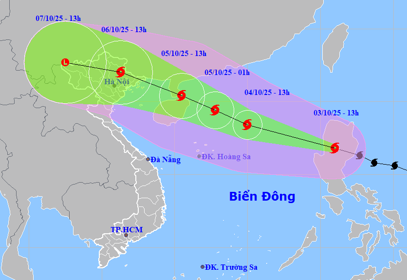
Specifically, over the next 24 hours, the storm will continue moving west-northwest at a speed of approximately 25 km/h, entering the South China Sea and potentially strengthening. By 13:00 on October 4th, the storm's center will be located in the northern South China Sea, about 480 km east-southeast of the Leizhou Peninsula (China). Wind speeds will reach levels 11-12, with gusts up to level 15. The level of natural disaster risk is level 3, applicable to the northern South China Sea area.
Over the next 24 hours, the storm maintained its direction of movement at a speed of 20-25 km/h and had the potential to intensify further. By 13:00 on October 5th, the storm's center was located off the southern coast of the Leizhou Peninsula (China), approximately 330 km east-southeast of Mong Cai (Quang Ninh); wind intensity at this time increased to level 12, with gusts up to level 15. The level of natural disaster risk was level 3, applicable to the northern South China Sea and the northern part of the Gulf of Tonkin.
The forecast for the following 24 hours indicates the storm will continue moving west-northwest at approximately 20 km/h, entering the northern part of the Gulf of Tonkin and gradually weakening. By 13:00 on October 6th, the storm's center will be located in the northeastern part of Northern Vietnam; wind speeds will reach level 8, with gusts up to level 10. The level of natural disaster risk is level 3, applicable to the northwestern sea area of the North East Sea, the northern part of the Gulf of Tonkin, and the coastal areas of provinces from Quang Ninh to Ninh Binh.
Over the next 72 to 96 hours, the storm moved west-northwest at approximately 15 km per hour, moving further inland and gradually weakening into a tropical depression, then a low-pressure area.
Forecasts indicate that in the eastern part of the North East Sea, winds will gradually strengthen to level 6-7, then increase to level 8-9; in the area near the storm's center, winds will reach level 10-11, with gusts up to level 14, and sea waves will be 4-6 meters high, resulting in extremely rough seas.
From October 4th, the northern South China Sea area will experience strong winds of force 8-10; in the area near the storm's center, winds will reach force 11-13, with gusts up to force 16, sea waves will be 4-6m high, and 6-8m near the storm's center, resulting in extremely rough seas.
Vessels operating in the aforementioned hazardous areas are susceptible to the effects of thunderstorms, tornadoes, strong winds, and high waves.


