
Typhoon No. 12 made landfall in Hue and Da Nang on the morning of October 23rd, bringing two periods of extremely heavy rain.
From the night of October 22nd to the morning of October 23rd, Typhoon No. 12 caused widespread heavy rain in Hue and Da Nang. Forecasts indicate two consecutive periods of rain could last until the end of October, with the risk of flooding and landslides.
On the afternoon of October 22nd, Typhoon No. 12 was located approximately 230 km east-northeast of Da Nang, moving slowly west-southwest at a speed of 10-15 km/h. It was forecast that by 10 PM that same day, when it was about 120 km from the mainland, Typhoon No. 12 would weaken to level 8, with gusts up to level 10.
Tonight and early tomorrow morning (October 23), Typhoon No. 12 will continue to weaken into a tropical depression, moving inland into the Thua Thien Hue - Da Nang area before gradually dissipating.
Despite its reduced intensity, Typhoon No. 12 still carried a massive amount of moisture from the East Sea, combined with strong northeasterly winds and easterly wind disturbances, creating a pattern of prolonged and widespread rainfall.
According to the National Center for Meteorological and Hydrological Forecasting, the circulation of typhoon No. 12, combined with cold air and easterly winds, will cause heavy rain in the central region for the next several days.
Phase 1 (from the night of October 22nd to 24th):Quang Tri and Da Nang will receive 400–600 mm of rain, with some areas exceeding 800 mm. Ha Tinh and Quang Ngai will receive 100–250 mm of rain, with some areas exceeding 400 mm.
Phase 2 (October 25-27):The heaviest rainfall is concentrated in Thua Thien Hue and Quang Tri provinces, with 200-300 mm of rain, and over 500 mm in some areas. Ha Tinh, Da Nang, and Quang Ngai provinces will receive 100-200 mm of rain, with localized areas exceeding 300 mm.
After October 27th, rain may continue due to the lingering effects of Typhoon No. 12 and the Northeast monsoon.
From the night of October 22nd to 28th, a major flood may occur on rivers from Quang Tri to Quang Ngai. Water levels in the Gianh and Thach Han rivers (Quang Tri) are expected to exceed alarm level 3; the Bo and Huong rivers (Hue) will rise above alarm level 3; and the Vu Gia, Thu Bon, and Tam Ky rivers (Da Nang) and the Tra Bong and Ve rivers (Quang Ngai) will also rise rapidly.
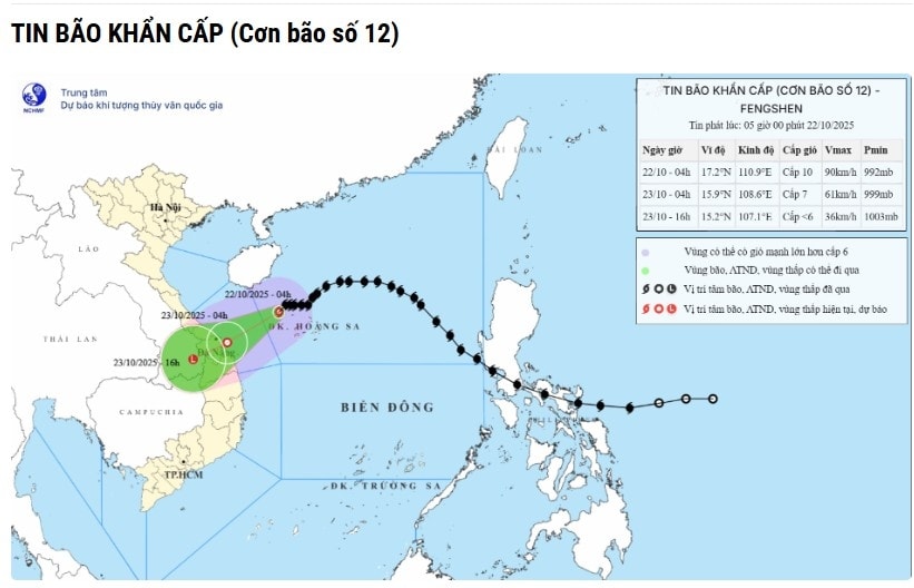
Typhoon No. 12 is likely to cause widespread and deep flooding from Quang Tri to Quang Ngai, accompanied by flash floods and landslides on mountain slopes. Local authorities need to proactively evacuate people from dangerous areas, especially those along rivers and at the foot of steep hills.
From the afternoon of October 22nd, due to the influence of the circulation of typhoon No. 12, winds on the coastal areas of Quang Tri - Da Nang gradually strengthened to level 6-7, gusting to level 8-9, strongest during the night of October 22nd and the morning of October 23rd. In inland areas, winds were level 5, gusting to level 6-7; in mountainous areas, winds were level 4-5, gusting to level 6-7.
In the Gulf of Tonkin, strong northeasterly winds of force 7, gusting to force 9. In the sea area from Quang Tri to Quang Ngai (including Con Co, Ly Son, and Cu Lao Cham), winds of force 6-7, near the storm's center force 8, gusting to force 10, waves 3-5 meters high, rough seas.
Additionally, coastal areas from Quang Tri to Da Nang may experience storm surge of 0.4–0.8 m due to Typhoon No. 12, combined with high tides causing flooding in low-lying areas and coastal erosion.
The meteorological agency warns that the circulation of Typhoon No. 12 may cause thunderstorms, tornadoes, and strong gusts of wind, both before and during landfall. People should limit going outdoors, reinforce their houses, check electrical systems, and secure boats safely.
The provinces in Central Vietnam have been instructed to implement emergency response plans to deal with heavy rain and flooding, ensuring the safety of residents, reservoirs, dams, and critical infrastructure during the severe impact of Typhoon No. 12.


