
Typhoon No. 15 changes direction and intensifies: 3 possible paths for the storm.
Typhoon No. 15 has changed direction to the West-Northwest, intensified, and is predicted to have three different scenarios as it approaches the East Sea, with one scenario having a probability of up to 70%.
Typhoon No. 15 changes direction and intensifies.
The National Center for Meteorological and Hydrological Forecasting provides the latest information on the development of Typhoon No. 15. This typhoon has adjusted its direction of movement to the West-Northwest, contrary to the initial forecast of Northwest, and is tending to intensify.
Specifically, at 10:00 AM on November 26th, the center of Typhoon No. 15 was located at approximately 12.5 degrees North latitude and 117.1 degrees East longitude, about 330 km east-northeast of Song Tu Tay Island. The strongest winds near the center of the typhoon reached levels 8-9 (62-88 km/h), with gusts up to level 11. The typhoon was moving west-northwest at a fairly rapid speed of about 20-25 km/h.
Mr. Mai Van Khiem, Director of the National Center for Meteorological and Hydrological Forecasting, stated that the subsequent development of Typhoon No. 15 shows significant differences between models and international meteorological agencies. Forecasts indicate that from now until November 28th, the typhoon will move in a west-northwest direction, then shift westward at a speed of approximately 20 km/h.
From November 28th, as the storm approaches the 113th meridian (in the northern, central, and southern parts of the South China Sea), the subtropical high-pressure system will weaken. The appearance of a low-pressure trough in the westerly wind zone at an altitude of 5,000m is likely to alter the storm's trajectory, leading to different possibilities regarding the path and impact of Typhoon No. 15 on Vietnam's sea and land areas.
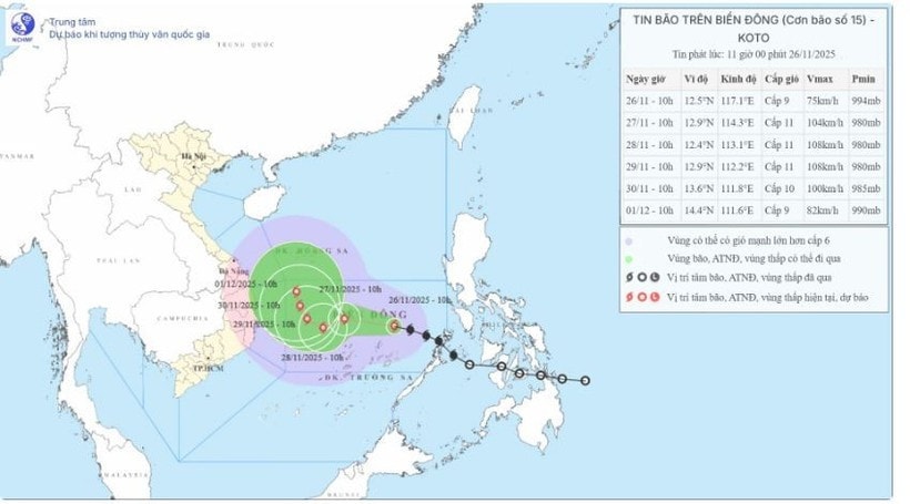
Currently, three scenarios regarding the storm's path and impact have been proposed.
Three scenarios have been presented for the path of Typhoon No. 15.
Scenario 1: The storm changes direction to the North (70% probability)
This is considered the most likely scenario. Upon reaching the northwestern sea area of the Truong Sa Special Administrative Region (approximately 500km east of the Gia Lai-Khanh Hoa coast), the storm will change direction and move northward. Afterward, it will weaken into a low-pressure area, which could then drift towards the mainland of the central provinces.
Impacts at sea:In the eastern part of the central South China Sea, winds will be strong, reaching levels 6-7. Near the storm's center, winds will be strong, reaching levels 8-9, with gusts up to level 11, and waves 4-6 meters high, resulting in very rough seas. From November 27th, the central South China Sea (including the northern part of the Truong Sa Special Administrative Region) may experience strong winds of levels 10-11, with gusts up to level 14, and waves 7-9 meters high, resulting in extremely rough seas.
Impacts on land:The likelihood of strong winds over land is low.
Heavy rain:The area from Da Nang to Lam Dong is likely to experience a period of widespread heavy rainfall in early December 2025, with the heaviest rainfall concentrated in the coastal areas. The predicted rainfall intensity is not expected to be as severe as the rainfall that occurred from November 16-21.
Scenario 2: The storm maintains a westward direction and moves towards Gia Lai - Khanh Hoa (20% probability)
In this scenario, Typhoon No. 15 maintains its direction, not changing northward but heading straight towards the Gia Lai-Khanh Hoa area. The typhoon's strongest intensity, when north of the Truong Sa Special Economic Zone, could reach level 11, with gusts up to level 13. Afterward, the typhoon will move westward towards the mainland of the central provinces, concentrating in the Gia Lai-Khanh Hoa area. Its intensity will weaken upon reaching land, to around level 8 or even down to a tropical depression.
Impacts on the sea and coastal areas:Coastal areas of provinces and cities from Da Nang to Lam Dong may experience strong winds of level 8, gusting to level 10, from November 29th, with waves 3-5m high and rough seas.
Heavy rain:Coastal areas from Da Nang to Lam Dong may experience heavy rainfall of 150-250mm between November 29th and December 1st. The likelihood is that the rain will not be as extreme as the rainfall from November 16th to 21st.
Scenario 3: The storm dissipates over the South China Sea (10% probability)
This is the least likely scenario. Typhoon No. 15 will gradually dissipate over the East Sea and will not cause any rain or wind damage to the mainland of Vietnam.


