
Typhoon No. 15 has weakened but is still approaching Gia Lai.
Typhoon No. 15 is moving slowly and gradually weakening, but it is still heading towards Gia Lai, causing strong winds and high waves in the East Sea. Local authorities are preparing for early response.
Typhoon No. 15 continues its complex trajectory, moving west-southwest this morning at a speed of only 3-5 km/h. At 4 AM, the typhoon's center was approximately 240 km northwest of Song Tu Tay Island. Maximum wind speeds remained at 117 km/h, equivalent to level 11, with gusts up to level 14. Compared to the previous day, the typhoon has weakened slightly and dropped one level.
The forecasting agency said that by tomorrow morning, the storm will still be located in the western part of the central South China Sea and will continue to weaken to level 10, with gusts up to level 14. At this time, its direction of movement will shift westward, but its speed will remain very slow.
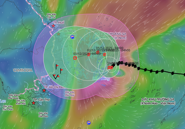
Forecasts indicate that by November 30th, the storm will be located approximately 300 km off the eastern coast of Gia Lai province. Wind speeds will decrease to level 9-10, with gusts up to level 13, and it will shift to a north-northwest direction. By December 1st, the distance will be reduced to 210 km, with an intensity of level 9 and gusts up to level 12.
International meteorological stations have different forecasts regarding the storm's intensity upon landfall. Japan reported that the storm weakened to around 65 km/h as it entered the Gia Lai area on December 2nd, while Hong Kong predicted that the most severely affected area would be the northern part of the province.
Despite the weakening of Typhoon No. 15, the central part of the East Sea, including the area north of the Truong Sa archipelago, still experiences strong winds of force 7-11, gusting to force 14. Wave heights in this area range from 4 to 9 meters, posing a danger to ships.
Offshore from Gia Lai to Khanh Hoa, winds will remain at force 6-8, gusting to force 9-10, creating waves 5-7 meters high. All vessels operating in the danger zone are at risk of being affected.
Meteorological experts say the trajectory of Typhoon No. 15 is influenced by the subtropical high-pressure system. As the high-pressure system weakens, its guiding ability decreases, causing the typhoon to gradually shift northward. At the same time, the closer it gets to the Vietnamese mainland, the further it moves away from the high-pressure area, causing its trajectory to continue to change.
The Prime Minister has instructed ministries, agencies, and provincial governments to prepare for the highest level of response, closely monitoring developments to ensure the safety of the people. Ministers and chairpersons of local People's Committees are responsible for the effectiveness of prevention and control measures.
The Border Guard reported that provinces from Da Nang to Ca Mau have informed more than 50,732 vessels with 281,689 people about the developments of Typhoon No. 15 so that they can proactively take shelter. No vessels remain in the danger zone. Many localities from Da Nang to Dak Lak have also lowered reservoir water levels to reduce the risk of flooding downstream.
Typhoon No. 15 formed from a tropical depression that intensified after passing through the eastern part of central Philippines and entering the South China Sea on the evening of November 25th. This is the 15th typhoon to appear in the region this year.
2025 was one of the years with the most storms and tropical depressions in the past 30 years. Natural disasters, mainly from storms and floods, caused 409 deaths, 727 injuries, and over 85 trillion VND in economic losses.


