Typhoon No. 3 weakened into a tropical depression.
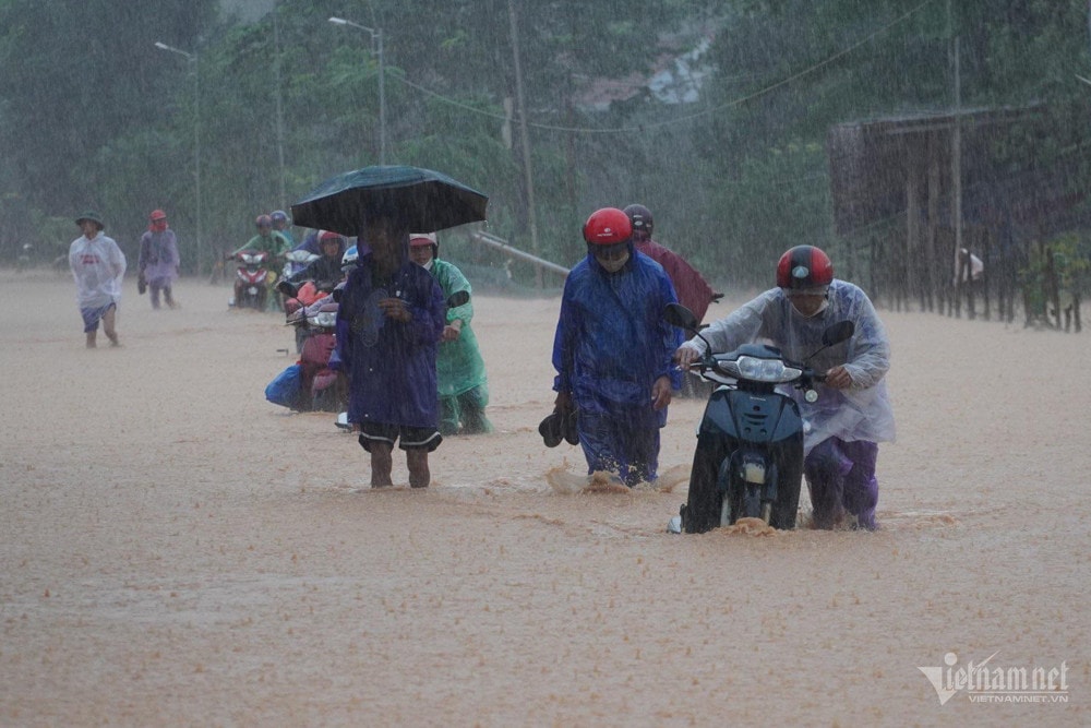
Due to the influence of the tropical depression (weakened from typhoon No. 3), on September 8th, the Northern region and Thanh Hoa experienced heavy rain, with some areas in the Northwest receiving up to 350mm of rainfall.
According to the National Center for Meteorological and Hydrological Forecasting, Typhoon No. 3 weakened into a tropical depression after making landfall.
At 4:00 AM on September 8th, the center of the tropical depression was located at approximately 21.2 degrees North latitude and 104.8 degrees East longitude, over land in the Northwest region of Vietnam. The strongest winds near the center of the tropical depression were at level 6 (39-49 km/h), gusting to level 7, moving westward at a speed of 10-15 km/h.
The Gulf of Tonkin (including Bach Long Vy and Co To islands) will experience strong winds today, reaching level 6, sometimes level 7, with gusts up to level 8; the sea will be rough. Further inland in Northern Vietnam, winds will reach level 6, with gusts up to level 7.
Weather forecast for today until tomorrow morning (September 9th): Due to the influence of a tropical depression, the Northeast region and Thanh Hoa will experience moderate rain, with some areas experiencing heavy to very heavy rain and thunderstorms. Rainfall amounts will generally range from 20-50mm, with some areas exceeding 100mm; mountainous areas will experience heavy rain, with some areas experiencing very heavy rain, with rainfall amounts generally ranging from 50-100mm, and some areas exceeding 200mm.
The northwestern region of Vietnam is experiencing heavy to very heavy rainfall, with common rainfall amounts of 100-200mm, and some areas receiving over 350mm.
Heavy rains are likely to cause flooding in low-lying areas; flash floods on small rivers and streams, and landslides on slopes.
Detailed weather forecast for September 8th across the country:
Hanoi
Cloudy, with rain, moderate rain, and thunderstorms. East to southeast winds at force 2-3. During thunderstorms, there is a possibility of tornadoes, lightning, and strong gusts of wind.
Lowest temperature: 24-26 degrees. Highest temperature: 27-29 degrees.
Northwestern region
Cloudy, with heavy to very heavy rain. Light wind.
Lowest temperature: 21-24 degrees Celsius, some places below 21 degrees Celsius. Highest temperature: 24-27 degrees Celsius, some places above 27 degrees Celsius.
Northeastern Vietnam
Cloudy, with rain, moderate rain and thunderstorms, locally heavy rain; particularly in mountainous areas, there will be heavy rain, locally very heavy rain and thunderstorms. East to southeast winds at level 3. During thunderstorms, there is a possibility of tornadoes, lightning, and strong gusts of wind.
Lowest temperature: 24-27 degrees. Highest temperature: 27-30 degrees.
Thanh Hoa - Thua Thien Hue
Cloudy with sunny periods, hot in some areas in the South; scattered showers and thunderstorms in the evening and at night. Southwesterly winds at 2-3 Beaufort. There is a possibility of tornadoes, lightning, and strong gusts of wind during thunderstorms.
Lowest temperature: 25-28 degrees. Highest temperature: 32-35 degrees.
Da Nang - Binh Thuan
Cloudy with sunny periods, hot in the North; scattered showers and thunderstorms in the evening and at night. Southwesterly winds at 2-3 Beaufort. There is a possibility of tornadoes, lightning, and strong gusts of wind during thunderstorms.
Lowest temperature: 27-30 degrees. Highest temperature: 33-36 degrees, with some areas exceeding 36 degrees.
Central Highlands
Cloudy, with scattered showers and thunderstorms in some areas; particularly in the afternoon and evening, there will be scattered showers and thunderstorms, with locally heavy rain in some places. Southwesterly winds of force 2-3. There is a possibility of tornadoes, lightning, and strong gusts of wind during thunderstorms.
Lowest temperature: 21-24 degrees. Highest temperature: 27-30 degrees.
Southern Vietnam
Cloudy, with scattered showers and thunderstorms in some areas; particularly in the afternoon and evening, there will be scattered showers and thunderstorms, with locally heavy rain in some places. Southwesterly winds of force 2-3. There is a possibility of tornadoes, lightning, and strong gusts of wind during thunderstorms.
Lowest temperature: 24-27 degrees. Highest temperature: 31-34 degrees.

