
Earthquake in Myanmar triggers warning of fault lines in Vietnam.
The 7.7 magnitude earthquake in Myanmar has served as a warning to Vietnam about the risk of seismic activity. Which fault zones are at high risk?
Earthquakes are natural phenomena caused by the movement of tectonic plates in the Earth's crust, or they may be related to volcanic activity. When they occur, the accumulated energy is released as seismic waves, which propagate to the surface and cause tremors. The severity of an earthquake depends on its intensity (measured in Richter scale - M) and depth, ranging from mild tremors to causing ground deformation, destroying houses and structures, and resulting in serious damage to infrastructure and loss of life.
Earthquake disaster in Myanmar
Due to the continuous activity of the Earth's tectonic plates, hundreds of thousands of earthquakes of varying magnitudes occur annually around the world, recorded by seismographs, most frequently along volcanic belts or along the boundaries between tectonic plates.
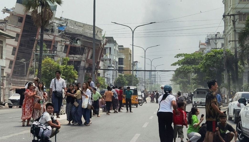
The earthquake on the afternoon of March 28th in Myanmar was also due to the country being situated between two large, continental-scale tectonic plates: the Indian plate and the Eurasian plate.
Associate Professor Dr. Nguyen Hong Phuong - Chairman of the Scientific Council of the Institute of Geophysics, Vietnam Academy of Science and Technology, stated: "The earthquake occurred along the large Sagaing fault, running north-south, with a length of approximately 1,200 km, which is part of the complex tectonic plate structure of the Tibetan Plateau."
According to Mr. Phuong: “This earthquake was very strong, arguably destructive, and one of the strongest earthquakes to occur in this country in the last 100 years. Since 1900, this area has recorded six earthquakes above 7 on the Richter scale, and this one is the largest earthquake in Myanmar since 1946 and possibly the strongest earthquake in modern times. The 1946 earthquake was estimated to have a magnitude of 7.6 and also occurred along the Sagaing fault.”
American geologist Jess Phoenix said, "The energy released by an earthquake like this is equivalent to about 334 atomic bombs." She also warned that aftershocks could last for months as the Indian tectonic plate continues to collide with the Eurasian plate beneath Myanmar.
According to Dr. Nguyen Xuan Anh, Director of the Institute of Geophysics, the earthquake in Myanmar was very strong (7.7 on the Richter scale), so even in locations far from the epicenter (more than 1,000 km) like Hanoi and Ho Chi Minh City, people could still feel the tremors. However, he emphasized that the current level of natural disaster risk for Vietnam is still level 0, meaning it is negligible. But neighboring countries like Thailand and China were significantly affected.
The strongest earthquakes in history have ever been recorded in Vietnam.
Although Vietnam is not located in a seismically active region like Japan or Indonesia, nor on tectonic plates like Myanmar, history has shown that many earthquakes of moderate to very strong intensity have occurred in various areas across the S-shaped strip of land.
Throughout history, from 114 to 2003, Vietnam recorded 1,645 earthquakes with magnitudes of 3 or higher on the Richter scale. Notably, earthquakes reaching magnitudes 7 and 8 occurred in many areas such as North Dong Hoi, Hanoi, Yen Dinh - Vinh Loc - Nho Quan, and Nghe An. Some events even date back hundreds of years, such as the magnitude 8 earthquakes in Hanoi in 1277, 1278, and 1285, followed by strong earthquakes in other areas such as Phan Thiet at the end of the 19th century. These events not only demonstrate the power of nature but also serve as a warning about the potential recurrence of seismic phenomena in the future.
According to the Vietnam and East Sea Earthquake Hazard Probability Atlas published by authors Nguyen Hong Phuong and Pham The Truyen (VVLĐC), there are 37 areas with the highest risk of earthquakes in Vietnam, mainly concentrated in the Northwest region, but with activity periods of hundreds or thousands of years.
Although Hanoi and Ho Chi Minh City are currently experiencing a relatively quiet period seismically, experts warn that Hanoi, situated on the Red River-Chay River fault line, is at risk of future earthquakes. Studies estimate the recurrence interval of earthquakes of approximately 5.4 magnitude on the Richter scale to be around 1,100 years, while the last major earthquake in Hanoi was recorded over 700 years ago, in 1285. Furthermore, the capital is also at risk of strong earthquakes occurring in neighboring fault zones such as the Lo River, Dong Trieu, and Son La.
Other areas of Vietnam, such as the Northwest, North Central, and the central coastal region, are also frequently affected by earthquakes. According to historical data, the 1935 Dien Bien Phu earthquake – recorded on the Ma River fault zone – with a magnitude of approximately 6.9 on the Richter scale, generated intense tremors that spread to many neighboring areas.
In 1983, the Tuan Giao area of Dien Bien province was hit by another strong earthquake with a magnitude of 6.7 on the Richter scale. This is considered one of the strongest earthquakes of the 20th century in Vietnam, causing significant damage to houses and infrastructure in the Northwest region, and creating tremors felt in more distant areas, raising concerns about geological instability.
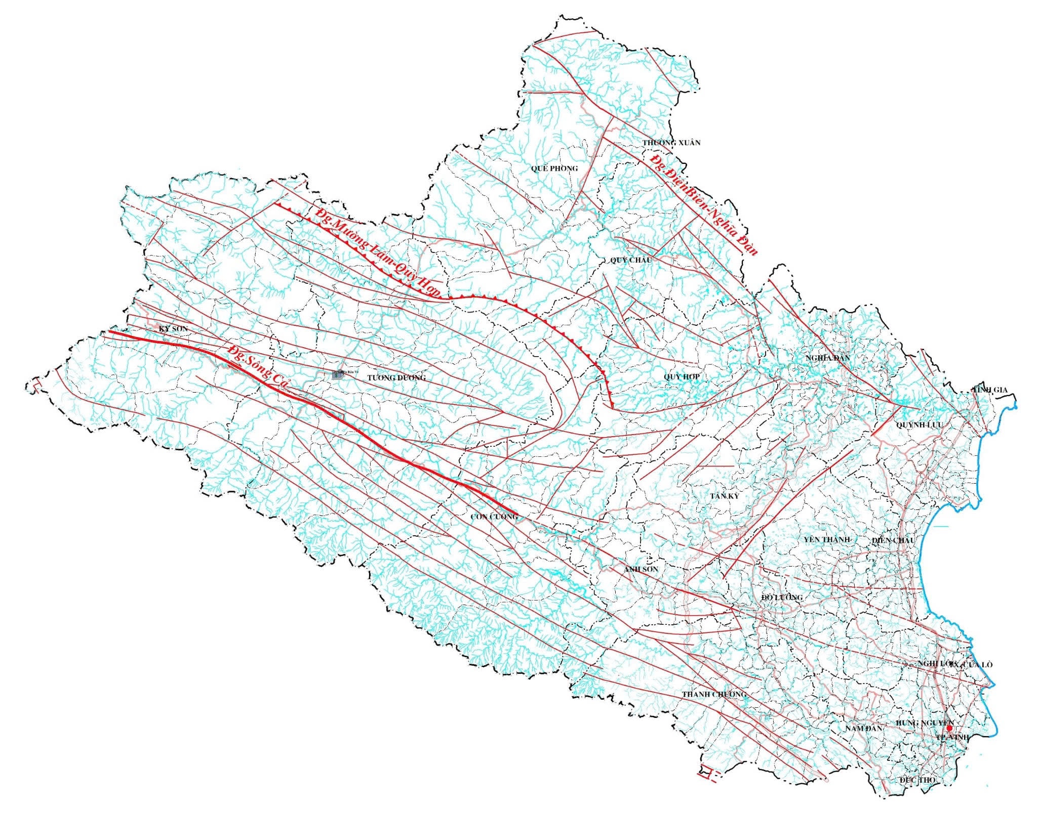
History of earthquakes in Nghe An
As mentioned, seismic activity is accompanied by geological fault activity. In the Nghe An area, there is the main Ca River fault along with a system of branch faults. The Ca River fault is linear, extending from Ban Ban in Laotian territory through Muong Xen town, running along the Nam Mo River, through Cua Rao, almost parallel to the Ca River to Khe Bo to Cay Chanh (Anh Son district), then along the Con River valley through Tan Ky town and straight to the sea at Cua Lo, then submerged under the sediments of the Thanh-Nghe continental shelf. The total length within Vietnam is 200 km.
The Ca River Fault is oriented NW-SE and dips southwest. The fault's depth of influence is approximately 60 km. The Ca River Fault has a long history of formation and development, undergoing many periods of dynamic changes from the mid-Paleozoic (approximately 500 million years ago) to the present. During the Cenozoic (approximately 66 million years ago), the activity of this fault zone was clearly evident with the formation of coal basins distributed along the main fault system and its branches (Than Khe Bo).
According to observational data from the Vietnam Institute of Geophysics, no earthquakes with a magnitude greater than or equal to 5.0 occurred in the Ca River basin during the 20th century and the early 21st century (most had magnitudes between 3.0 and 5.0 on the Richter scale). However, historical records mention five earthquakes with magnitudes greater than 5 in the years 1136 (1137?), 1767, 1777 (two earthquakes), and 1821. Most notably, the earthquake in 1136 (1137?) caused the river water to turn blood red; the 1767 earthquake caused landslides; and the 1821 earthquake caused significant damage to houses. According to Dr. Nguyen Dinh Xuyen (Vietnam Institute of Geophysics, 2004), the 1821 earthquake had a seismic intensity of l0 = 8 and a magnitude of M = 6.0.
- An earthquake in 1136 (1137?) was recorded in the Dien Chau district. Seismologists from the Institute of Geophysics believe that this earthquake had a destructive intensity of level VII on the surface, but to make the river water turn red, the earthquake must have been very strong. It could have been stronger than the Tuan Giao earthquake in 1983, meaning it could have been above magnitude 6.7.
- The 1767 earthquake is recorded in the Dien Chau - Quynh Luu area with surface tremors reaching magnitude VII, but it is also recorded that it caused landslides in Thanh Hoa, so it may have been a strong earthquake.
Earthquakes are classified according to the Richter scale (M). They are categorized as follows: Micro-earthquakes, M=2.0; Weak earthquakes, M=2.0-3.9; Mild earthquakes, M=4.0-4.9; Moderate earthquakes, M=5.0-5.9; Strong earthquakes, M=6.0-6.9; Very strong earthquakes, M=7.0-7.9; and Destructive earthquakes, M=8-9.
Warnings
According to Associate Professor Dr. Nguyen Hong Phuong, Vietnam is not located on the Ring of Fire, so we are safe and will not experience devastating earthquakes like the one in Sumatra - Andaman in 2024 (9.3 magnitude) that claimed the lives of 300,000 people, or the strong earthquake in Myanmar recently. However, Vietnam still has the potential for strong earthquakes because the country has many fault systems tens to hundreds of kilometers long and deep faults, so earthquakes can still occur.
Given such risks, appropriate solutions must be implemented to ensure the safety of structures, houses, etc. Earthquakes are unavoidable, but damage can be mitigated when major earthquakes occur.
According to Associate Professor Cao Dinh Trieu, Director of the Institute of Applied Geophysics (Vice President of the Vietnam Association of Geophysical Sciences and Technology), Vietnam does not yet have a law on earthquakes, so regulations regarding seismic resistance in construction in general and high-rise buildings in particular are still very fragmented and lack specificity.
Countries like Japan, China, and the Philippines, which frequently experience earthquakes due to their location on the Western Pacific Rim, have very strict regulations regarding the construction of residential buildings and high-rises. These structures must meet seismic resistance requirements to withstand earthquakes.
Based on the above facts, Mr. Trieu believes that in the future, Vietnam needs to pay more attention to earthquake resistance in construction projects, especially residential buildings (such as high-rise apartment buildings, etc.), to ensure safety and minimize potential risks that could affect the people.
References:
1. Dr. Cao Dinh Trieu, Dr. Le Van Dung, Dr. Bui Van Nam, Dr. Cao Dinh Trong, Dr. Mai Thi Hong Tham (2023): “Some features of seismic tectonic characteristics of the Song Ca - Rao Nay area”. Journal of Marine Science and Technology, No. 3A, Vol. 13, Hanoi, pp. 183-191
2. Dr. Thai Anh Tuan, Dr. Nguyen Duc Vinh (2023): “Earthquake hazard forecasting in the Ca River - Rao Nay basin based on a new deterministic approach”, Journal of Marine Science and Technology, No. 3A, Vol. 13, Hanoi, pp. 9-16.


