
August 19th: Nghe An experiences very heavy rain due to Typhoon No. 3.
(Baonghean.vn) -Due to the influence of the storm, Nghe An will experience heavy to very heavy rain. From this morning (August 19th), the wind in the sea area of North Central Vietnam will gradually strengthen to level 8-10.Level 12-14 gusts.
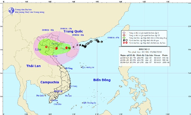 |
| The path of Typhoon No. 3. |
According to the forecast of the North Central Vietnam Meteorological and Hydrological Station,Due to the influence of the western circulation of typhoon No. 3, the North Central region experienced moderate to heavy rain. The total rainfall in the past 12 hours was generally 30-80mm, with some areas receiving more, such as Cam Thuy with 101mm.
At 4:00 AM on August 19thThe center of Typhoon No. 3 is located at approximately 20.4 degrees North latitude and 108.1 degrees East longitude, over the northern part of the Gulf of Tonkin, about 180km east of the Hai Phong-Ninh Binh coastline. The strongest winds near the center of the typhoon are at level 9 (75-90 km/h).Shockwaves of level 10-12.
Forecast for the next 6 hoursThe storm is moving westward at a speed of 15-20 km/h and is expected to intensify further, directly affecting the northeastern and north-central provinces. By 10:00 AM on August 19th, the storm's center was located at approximately 20.4 degrees North latitude and 106.8 degrees East longitude, right over the coastal areas of Hai Phong and Ninh Binh provinces. The strongest winds near the storm's center reached levels 9-10 (75-100 km/h).gusts of wind at level 11-13.
Forecast for the next 6 to 12 hoursThe storm is moving westward at a speed of 15-20 km/h, making landfall in the provinces of Hai Phong and Ninh Binh, and continuing to directly affect the northeastern and north-central provinces. By 4 PM on August 19th, the storm's center was located at approximately 20.4 degrees North latitude and 105.6 degrees East longitude, over the northern delta provinces and northern Thanh Hoa. The strongest winds near the storm's center reached level 8 (60-75 km/h).Level 10-12 gusts.
AssessmentWeather in the North Central regionDay and night of August 19, 2016:
Over the sea area of North Central Vietnam, winds are gradually strengthening to level 8-10.Level 12-14 gustsSea waves are 2-3 meters high. The sea is very rough. On land, coastal districts in the North Central region are experiencing increasingly strong winds, reaching levels 6-7, with gusts up to levels 8-11. Disaster risk level: level 3.
Due to the direct influence of the circulation of typhoon No. 3, the North Central region will continue to experience rain, scattered moderate to heavy rain and thunderstorms. Rainfall in northern Nghe An and Thanh Hoa is likely to reach 100-150 mm, with some areas exceeding 150 mm; in southern Nghe An and Ha Tinh: 50-100 mm, with some areas exceeding 100 mm. The level of natural disaster risk is level 1-2.
Note: The storm's development remains complex; please closely monitor subsequent weather forecasts.
Ha Chi
| RELATED NEWS |
|---|


