
Weather forecast for June 5th: Warning of thunderstorms and tornadoes.
(Baonghean.vn) - Due to the influence of the western circulation of the tropical depression, provinces from Thanh Hoa to Thua Thien Hue will experience rain, moderate rain, with some areas experiencing heavy to very heavy rain and thunderstorms. During thunderstorms, there is a possibility of tornadoes, waterspouts, and strong gusts of wind.
At 4:00 AM on June 5thThe center of the tropical depression is located at approximately 16.5 degrees North latitude and 110.9 degrees East longitude, just west of the Hoang Sa archipelago. The strongest winds near the center of the tropical depression are at level 7 (50-60 km/h).level 9 gust.
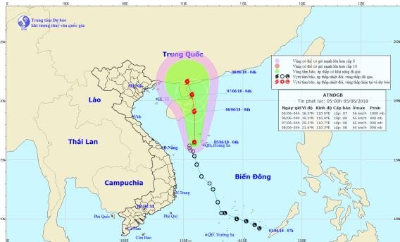 |
| The path and location of the tropical depression. Photo: National Center for Hydro-Meteorological Forecasting. |
Forecast for the next 24 hoursThe tropical depression is moving mainly northward at a speed of about 10km per hour and has the potential to strengthen into a typhoon. By 4:00 AM on June 6th, the typhoon's center was located at approximately 19.1 degrees North latitude; 110.9 degrees East longitude, just over the sea east of Hainan Island.
The strongest winds near the center of the storm are at level 8 (60-75 km/h).level 10 surgeThe area of strong winds (level 6, gusting to level 8 or higher) extends approximately 80km from the storm's center.
The sea areas off the coast of provinces/cities from Da Nang to Quang Ngai (including Ly Son island district) experienced strong gusts of wind up to level 6 this early morning; the sea was rough.
Due to the influence of a tropical depression that is likely to strengthen into a storm, the western part of the North East Sea (including the waters around the Hoang Sa archipelago) will experience heavy thunderstorms; winds will be strong, reaching levels 6-7, later increasing to level 8.level 10 surgeThe sea is very rough. Off the coast of Central Vietnam and in the Gulf of Tonkin, there will be showers and thunderstorms accompanied by tornadoes and strong gusts of wind.
Dangerous areas in the South China Sea over the next 24 hours.: (strong winds of level 6 or higher) from latitude 15.0 to 21.0 degrees North; from longitude 108.0 to 113.0 degrees East.Level of natural disaster risk: level 3.
Over the next 24 to 48 hoursThe storm continued to move northward at a speed of 5-10 km/h. By 04:00 on June 7th, the storm's center was located at approximately 20.5 degrees North latitude and 110.7 degrees East longitude, over the eastern part of the Leizhou Peninsula (China). The strongest winds near the storm's center reached level 8 (60-75 km/h).level 10 surgeThe area of strong winds (level 6, gusting to level 8 or higher) extends approximately 80km from the storm's center.Level of natural disaster risk: level 3.
Over the next 48 to 72 hoursThe storm is moving mainly in a north-northwest direction, at a speed of about 5 km per hour.
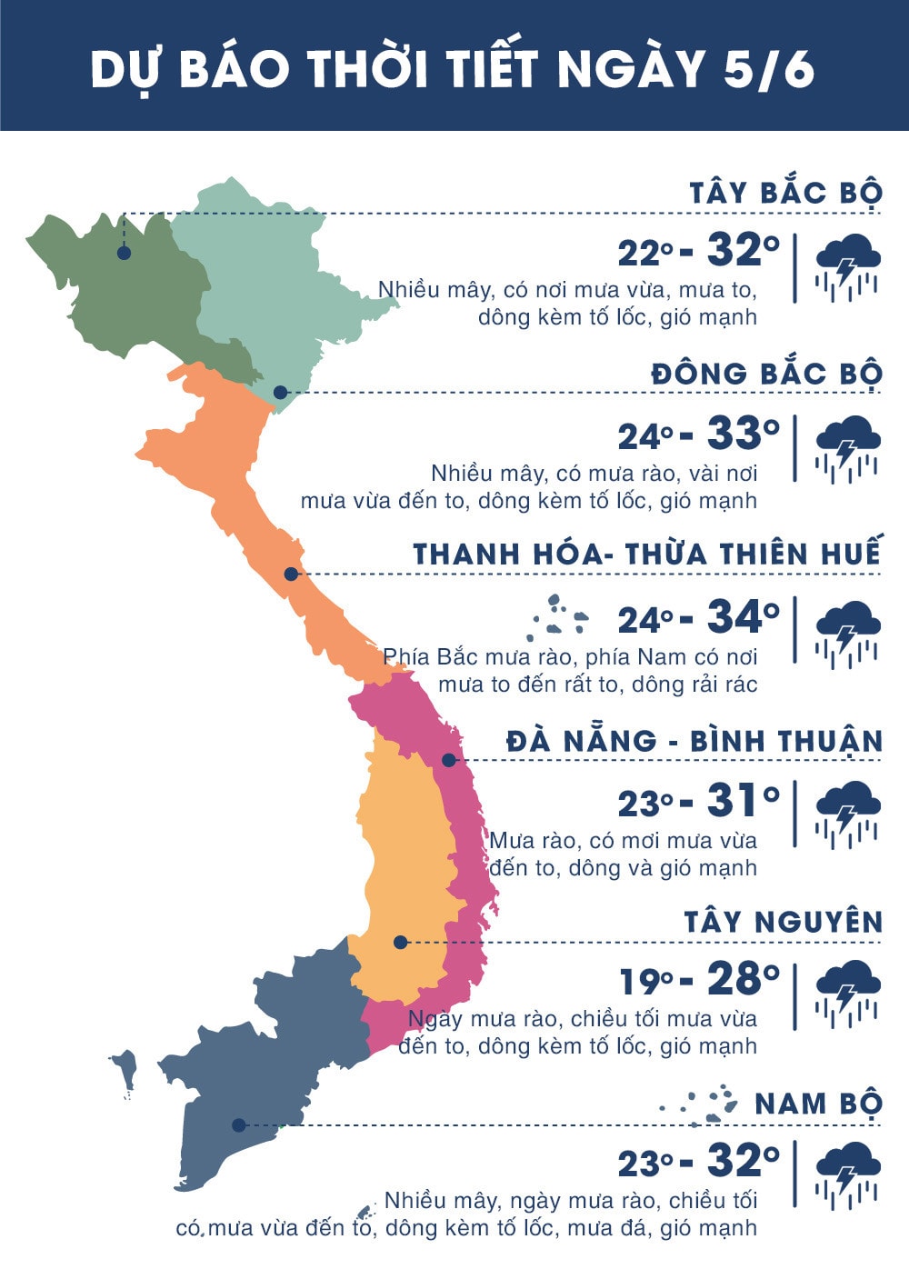 |
| Today's (June 5th) temperatures across the country. Source: Zing.vn |


