
Emergency storm warning (Storm No. 4): Nghe An province is experiencing increasingly strong winds, reaching levels 5-6, with gusts up to level 7.
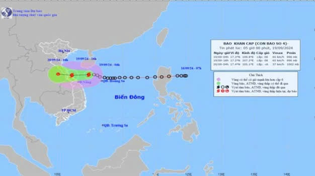
Early this morning (September 19th), the tropical depression in the northeastern area of the Hoang Sa archipelago strengthened into a typhoon, the 4th typhoon of 2024. At Con Co Island (Quang Tri), strong winds of level 6, gusting to level 7, were recorded.
Retreat04 hour,The storm's center is located at approximately 17.3 degrees North latitude and 109.8 degrees East longitude, 210km northeast of Da Nang and about 260km east of Quang Tri. The strongest winds near the storm's center are at level 8 (62-74km/h), with gusts up to level 10; it is moving mainly westward at a speed of about 20km/h.
2. Forecast of storm developments (over the next 24 to 48 hours):
| Expected timenewspaper | Direction, speed | Location | Intensity | Hazardous areadanger | Level of natural disaster risk (Affected area) |
| 4 PM/September 19 | West, approximately 20-25 km/h | 17.2 N-107.2 E; in the coastal waters from Quang Tri to Quang Nam | Level 8, then level 10 | 15.0N-19.5N; west of longitude 113.0E | Grant3: The western sea area of the North East Sea region (including the Paracel Islands); the sea area from Nghe An to Quang Ngai (including Ly Son Island, Cu Lao Cham, Con Co, Hon Ngu); the mainland area from Ha Tinh to Quang Ngai. Male |
| 04:00/20/9 | West-northwest, approximately 15-20 km/h, deceleration It gradually weakened into a low-pressure area. | 17.4 N-105.1 E; over central Laos | Level 6 | 15.0N-19.5N; west of meridian 110.0E | Grant3: The sea area from Nghe An to Quang Nam (including Cu Lao Cham, Con Co, and Hon Ngu islands); the mainland area from Ha Tinh to Quang Nam |
3.Warning about the development of thea Storm (in 48)arrive72 now):
4. Forecast of the impact of tropical depressions/storms:
*Rice seedlingsnh,wateroffering,numbernglargen
At sea:
The sea area of Nghe An (including Mat Island and Hon Ngu Island) will experience strong winds of force 6-7, with waves 2.0-4.0m high. In the area near the storm's center, winds will reach force 8 (62-74km/h), gusting to force 10 (89-102km/h), with waves 3.0-5.0m high, and rough seas.
Eviluboatnpaintingtdegreeinsidefishcdanger zonei abovetopicuIt is possible that sheudozencdegreengtubera dong,tornado,rice paddy windnh,big waves.
Abovestonetimmediatelyn:
From the morning of September 19th, the mainland and coastal areas of Nghe An province (including Hon Ngu island) experienced increasingly strong winds, reaching levels 5-6, with gusts up to level 7.
*Rising water,big waves:
On September 19th, both day and night, the waves in the offshore area of Nghe An - Ha Tinh were 2.0-4.0m high.
Storm surges pose a risk of flooding in coastal areas:
Coastal areas of Nghe An province need to be wary of storm surges of 0.3-0.5m.
Boat mooring areas,aquaculture area,dikes,Seawall in the skyngThe aforementioned hazards are all susceptible to the effects of strong winds.,numbernglargen andwaterc surge caused by the storm.
*heavy rainn
From September 19th to September 20th, Nghe An province will experience moderate to heavy rain, with some areas receiving very heavy rain and scattered thunderstorms. The predicted rainfall amounts are: 50-100 mm in mountainous areas, with some places exceeding 150 mm; and 70-150 mm in the midland and coastal plains, with some places exceeding 250 mm.
Heavy rains have led to flooding in urban areas.,densely populated areas where water cannot drain quickly enough..Be prepared for the appearance of strong thunderstorm clouds ahead of the storm's circulation..In the event of heavy thunderstorms.,The consequence of this is that trees are broken and fallen., corrugated iron roofs,signnThe advertising sign could be blown away in the air..


